Sulaymaniyah Governorate
| |
|---|---|
  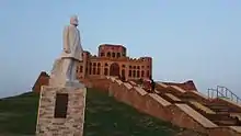 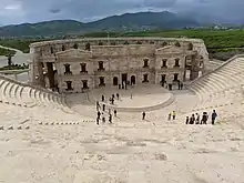 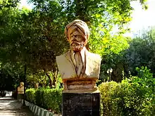 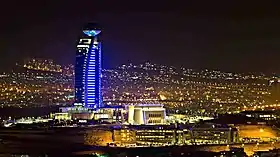 Top-bottom, R-L: View over Suleymaniyah Sulaymaniyah Museum • Sherwana Castle Roman amphitheater • Sharafkhan Bidlisi statue Suleymaniyah at night Clockwise, from left: Sulaymaniyah with Dukan Lake, Halabja and Ranya | |
|
Seal | |
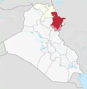 Location of the Sulaymaniyah Governorate (red) – in Iraq (red, beige & light grey) | |
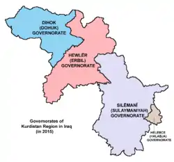 Sulaymaniyah Governorate within the Kurdistan Region[2] | |
| Coordinates: 35°31′N 45°19′E / 35.517°N 45.317°E | |
| Country | |
| Autonomous region | |
| Capital | Sulaymaniyah |
| Area | |
| • Total | 20,143.91 km2 (7,777.61 sq mi) |
| Population (2020) | |
| • Total | 2,250,000 |
| HDI (2018) | 0.706[3] high · 2nd of 17 |
| Website | www |
Sulaymaniyah Governorate (Sorani Kurdish: پارێزگای سلێمانی; Kurmanji Kurdish: Parêzgeha Silêmaniyê;[4][5] Arabic: محافظة السليمانية) or Sulaymaniyah Province is a mountainous governorate in the Kurdistan Region of Iraq. Its largest city is Sulaymaniyah. Halabja Governorate was formerly the Halabja District of Sulaymaniyah, until it became a separate governorate in 2014.
Provincial Government
- Governor: Haval Abubakir
- Deputy Governor: Ahmed Ali Ahmed
- Provincial Council Chairman (PCC): Azad Mohammad Amin
Districts
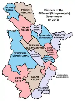
Districts of the Sulaymaniyah Governorate[6]
| District | Sub-districts | Capital |
|---|---|---|
| Çemçemal | Shwan | Çemçemal |
| Aghjalar | ||
| Takiya | ||
| Sangaw | ||
| Qadirkaram | ||
| Derbendîxan | not determined | Derbendîxan |
| Dokan | Surdaş | Dokan |
| Chinaran | ||
| Bingrd | ||
| Khidran | ||
| Piramagrun | ||
| Kalar | Kalar | Kalar |
| Pebaz | ||
| Shekh Tawil | ||
| Rizgari | ||
| Xaneqîn (northern part only; mostly disputed) | Qoratu and Maidan | Meydan |
| Kifrî (mostly disputed) | not determined | Kifrî |
| Mawet | Mawet | |
| Pêncwên | Garmik | Pêncwên |
| Nalparez | ||
| Pişder | Hero | Qeladizê |
| Nawdeşt | ||
| Halşo | ||
| Zharawa | ||
| Esewa | ||
| Qeredax | Qeredax | |
| Ranya | Çwarqurne | Ranya |
| Betwata | ||
| Hajiyawa | ||
| Sarkapkan | ||
| Seyid Sadiq | Siruchik | Seyid Sadiq |
| Barzinja | ||
| Şarezûr | Zarayan | |
| Şarbajêrr | Zalan | Şarbajêrr |
| Zhazhla | ||
| Siwayil | ||
| Sitak | ||
| Gapilon | ||
| Silêmanî | Bazyan | Silêmanî |
| Tanjaro | ||
| Bakrajo | ||
See also
References
- "Map of area of Kurdistan Region & its Governorates". www.krso.net.
- ↑ "Map of area of Kurdistan Region & its Governorates". www.krso.net.
- ↑ "Sub-national HDI - Area Database - Global Data Lab". hdi.globaldatalab.org. Retrieved 2018-09-13.
- ↑ "Li sînorê parêzgeha Silêmaniyê gule li du binkeyên hikûmetê hatin berdan" (in Kurdish). Retrieved 21 December 2019.
- ↑ "پارێزگای سلێمانی". slemani.gov.krd (in Kurdish). Retrieved 21 December 2019.
- ↑ "The Map Of districts Of Iraqi Kurdistan Region". www.krso.net.
External links
Wikivoyage has a travel guide for Sulemania Governorate.
Wikimedia Commons has media related to Sulaymaniyah Governorate.
- Official website
 (in Sorani Kurdish)
 - Iraq Inter-Agency Information & Analysis Unit Reports, Maps and Assessments of Iraq's Governorates from the UN Inter-Agency Information & Analysis Unit
This article is issued from Wikipedia. The text is licensed under Creative Commons - Attribution - Sharealike. Additional terms may apply for the media files.