| Ben Cruachan | |
|---|---|
| Cruachan Beann | |
 Ben Cruachan | |
| Highest point | |
| Elevation | 1,126 m (3,694 ft)[1] |
| Prominence | c. 881 m Ranked 14th in British Isles |
| Parent peak | Ben Lawers |
| Listing | Munro, Marilyn, Council top (Argyll and Bute) |
| Naming | |
| English translation | mountain of peaks[2] |
| Language of name | Gaelic |
| Pronunciation | Scottish Gaelic: [ˈkʰɾuəx nə ˈpeɲə] |
| Geography | |
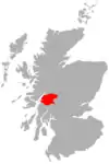
| Location | Loch Etive/Loch Awe, Scotland |
| Parent range | Grampian Mountains |
| OS grid | NN069304 |
| Topo map | OS Landranger 36 |
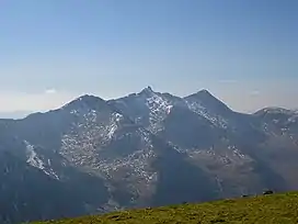
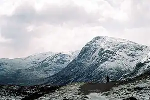
Ben Cruachan (Scottish Gaelic: Cruachan Beann)[3] is a mountain that rises to 1,126 metres (3,694 ft), the highest in Argyll and Bute, Scotland. It gives its name to the Cruachan Dam, a pumped-storage hydroelectric power station located in a cavern inside the mountain. It is the high point of a ring of mountains, known as the Cruachan Horseshoe, that surrounds the power station reservoir. The horseshoe includes a further Munro (Stob Diamh), a Corbett (Beinn a' Bhuiridh), and several subsidiary summits. "Cruachan!" is the battle cry of Highland clans Campbell and MacIntyre.
See also
References
- ↑ "Ben Cruachan". walkhighlands.co.uk. 2013. Retrieved 2 November 2013.
- ↑ Butterfield, Irvine (1986). The High Mountains of Britain and Ireland. London: Diadem Books. ISBN 978-0-906371-71-8.
- ↑ "Ben Cruachan". Ainmean-Àite na h-Alba: Gaelic Place-Names of Scotland.
External links
Wikimedia Commons has media related to Ben Cruachan.
- Computer generated Summit Panorama Ben Cruachan index
- Visit Cruachan - Ben Cruachan, the Hollow Mountain - visitors' information
| Northern Highlands (20) |    | |
|---|---|---|
| Western Highlands (20) | ||
| Central and Eastern Highlands (13) | ||
| Southern Highlands (15) | ||
| Islands (13) | ||
| Scottish Lowlands, England and Wales (13) | ||
| Republic of Ireland, Northern Ireland (25) | ||
 |
|  | |
This article is issued from Wikipedia. The text is licensed under Creative Commons - Attribution - Sharealike. Additional terms may apply for the media files.