| Bolshoy Cheremshan River | |
|---|---|
 | |
| Location | |
| Country | Tatarstan and Ulyanovsk Oblast, Russia |
| Physical characteristics | |
| Source | |
| • location | Bugulma-Belebey Hills |
| Mouth | Kuybyshev Reservoir, Volga |
• coordinates | 54°10′10″N 49°32′44″E / 54.16944°N 49.54556°E |
• elevation | 53 m (174 ft) |
| Length | 336 km (209 mi) |
| Basin size | 11,500 km2 (4,400 sq mi) |
| Discharge | |
| • average | 1,660 m3/s (59,000 cu ft/s) (maximal) |
| Basin features | |
| Progression | Volga→ Caspian Sea |
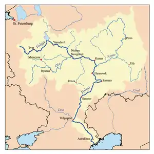
Bolshoy Cheremshan (Russian: Большой Черемшан, literally Greater Cheremshan, Tatar: Олы Чирмешән) is a river in Russia, a left tributary of the Volga between the Kama and Samara. It is 336 kilometres (209 mi) long, and has a drainage basin of 11,500 square kilometres (4,400 sq mi).[1] It flows southwest to the Volga near Dimitrovgrad. The main inflows are the Bolshaya Sulcha and Maly Cheremshan. The maximal discharge is 1,660 cubic metres per second (59,000 cu ft/s) (1979), and the minimal mineralization is 600-800 mg/l. The riverbed is meandering and the meadows are wide. From around 1650 the Trans-Kama Line of forts ran along or near the Cheremshan.
References
- ↑ «Река Б.ЧЕРЕМШАН», Russian State Water Registry
- "Олы Чирмешән". Tatar Encyclopaedia (in Tatar). Kazan: The Republic of Tatarstan Academy of Sciences. Institution of the Tatar Encyclopaedia. 2002.
| Tributaries |
|  |
|---|---|---|
| Reservoirs | ||
| Hydroelectric stations | ||
| Canals | ||
| Cities | ||
This article is issued from Wikipedia. The text is licensed under Creative Commons - Attribution - Sharealike. Additional terms may apply for the media files.