| Gave d'Aspe | |
|---|---|
 | |
 | |
| Location | |
| Country | France |
| Physical characteristics | |
| Source | |
| • location | Pyrenees, Aspe Circus |
| Mouth | |
• location | Gave d'Oloron |
• coordinates | 43°11′39″N 0°36′29″W / 43.19417°N 0.60806°W |
| Length | 58 km (36 mi) |
| Basin features | |
| Progression | Gave d'Oloron→ Gaves réunis→ Adour→ Atlantic Ocean |
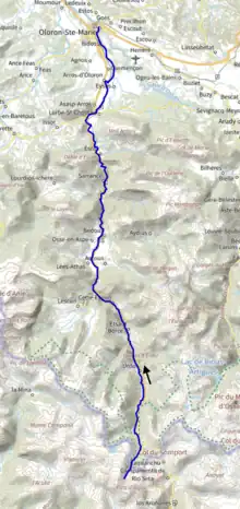
The Gave d'Aspe (French pronunciation: [ɡav dasp]) is a torrential river flowing through the Aspe Valley, one of the three main valleys of the High-Béarn (Pyrénées-Atlantiques), in the southwest of France. It is 58.1 km (36.1 mi) long.[1]
It is formed in the Aspe Cirque, below the Aspe peak, elevation 2,643 metres (8,671 ft), in Spain.
After joining the Gave d'Ossau, in Oloron-Sainte-Marie, it forms the Gave d'Oloron.
Main tributaries
- (R) Arnousse
- (L) Gave de Baralet
- (R) Sescouet
- (L) Gave de Bélonce
- (R) Escuarpe, in Cette-Eygun
- (L) Gave de Lescun
- (R) Berthe, from Accous
- (L) Malugar, from Athas
- (L) Arricq d'Osse
- (R) Gabarret, aka Gave d'Aydius
- (R) Barrescou, from the Marie-Blanque Pass
- (L) Lourdios
- (R) Ourtau
Départements and towns
References
This article is issued from Wikipedia. The text is licensed under Creative Commons - Attribution - Sharealike. Additional terms may apply for the media files.