Native name: Maore, Mahori | |
|---|---|
 Grande-Terre administrative | |
 | |
| Geography | |
| Location | Indian Ocean and Mozambique Channel |
| Coordinates | 12°49′55″S 45°08′58″E / 12.831887°S 45.149474°E |
| Area | 368 km2 (142 sq mi) |
| Area rank | ~11th |
| Highest elevation | 660 m (2170 ft) |
| Highest point | Mount Benara |
| Administration | |
| Largest settlement | Mamoudzou (pop. 53,022 (2009) 186,452[1]) |
| Demographics | |
| Population | (2010) |
| Pop. density | 499/km2 (1292/sq mi) |
| Ethnic groups | Shimaore, Bushi, Arabs, Swahilis, French |
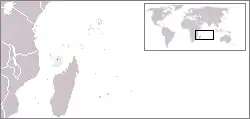
Grande-Terre (French pronunciation: [ɡʁɑ̃d tɛʁ]; Maore or Nyambo Bole in Shimaore) is the main island of the French overseas region of Mayotte.[2] The island is located in the northern Mozambique Channel in the Indian Ocean, namely between northwestern Madagascar and northeastern Mozambique.
.jpg.webp) Mayotte, Grande Terre
Mayotte, Grande Terre.jpg.webp) The outskirts of Mayotte
The outskirts of Mayotte
History
References
- ↑ "INSEE Infos No 32" (PDF). INSEE (in French). Government of France. Retrieved 2007-12-02.
- ↑ "Mayotte devient le 101e département français", Portail du Gouvernement, 4 April 2011, archived from the original on 25 July 2011,
C'est pourquoi Mayotte devient le 101e département français et le 5e département d'Outre-Mer et région d'Outre-Mer.
This article is issued from Wikipedia. The text is licensed under Creative Commons - Attribution - Sharealike. Additional terms may apply for the media files.