Hòa Vang district
Huyện Hòa Vang | |
|---|---|
 Hòa Vang District People's Committee | |
 Seal | |
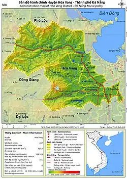 Administration map of the district in Da Nang | |
| Country | |
| Region | South Central Coast |
| Municipality | Da Nang |
| Area | |
| • Total | 273 sq mi (708 km2) |
| Population (2018) | |
| • Total | 201,070 |
| Time zone | UTC+7 (Indochina Time) |
Hòa Vang is a rural district (huyện) of Da Nang in the South Central Coast region of Vietnam. It is bordered by Liên Chiểu and Cẩm Lệ districts to the east, Thừa Thiên-Huế province to the north and northwest, and Quảng Nam province to the west and south.

Da Nang Martyrs Cemetery, Hòa Khương
Administration
As of 2003 the district had a population of 106,746.[1] The district covers an area of 708 km².[1]
Hòa Vang district is subdivided into 11 rural communes (xã):
- Hòa Bắc
- Hòa Liên
- Hòa Ninh
- Hòa Sơn
- Hòa Nhơn
- Hòa Phong
- Hòa Phú
- Hòa Khương
- Hòa Châu
- Hòa Phước
- Hòa Tiến
The district capital lies at Hòa Phong commune.
References
- 1 2 "Districts of Vietnam". Statoids. Retrieved March 20, 2009.
16°04′59″N 108°00′00″E / 16.083°N 108.000°E
| Da Nang city |  | |
|---|---|---|
| Bình Định province | ||
| Bình Thuận province | ||
| Khánh Hòa province |
| |
| Ninh Thuận province | ||
| Phú Yên province | ||
| Quảng Nam province | ||
| Quảng Ngãi province | ||
※ denotes provincial seat. / § Sovereignty over the Hoàng Sa and Trường Sa archipelagoes is disputed as of 1 January 2024. | ||
This article is issued from Wikipedia. The text is licensed under Creative Commons - Attribution - Sharealike. Additional terms may apply for the media files.