Heiligenkreuz im Lafnitztal | |
|---|---|
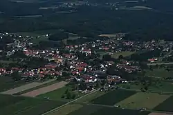 Aerial view | |
|
Flag  Coat of arms | |
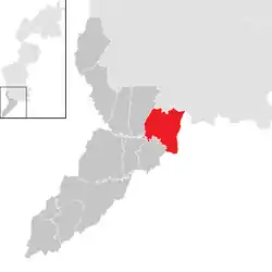 Location within Jennersdorf district | |
 Heiligenkreuz im Lafnitztal Location within Austria | |
| Coordinates: 46°59′N 16°16′E / 46.983°N 16.267°E | |
| Country | Austria |
| State | Burgenland |
| District | Jennersdorf |
| Government | |
| • Mayor | Eduard Zach (SPÖ) |
| Area | |
| • Total | 23.78 km2 (9.18 sq mi) |
| Elevation | 243 m (797 ft) |
| Population (2018-01-01)[2] | |
| • Total | 1,231 |
| • Density | 52/km2 (130/sq mi) |
| Time zone | UTC+1 (CET) |
| • Summer (DST) | UTC+2 (CEST) |
| Postal code | 7561 |
| Website | http://www.heiligenkreuz-lafnitztal.at/ |
Heiligenkreuz im Lafnitztal (Hungarian: Rábakeresztúr, Rába-Keresztúr, Slovene: Sveti Križ) is a town in the district of Jennersdorf in the Austrian state of Burgenland close to the Austria/Hungary border.
Geography
Cadastral communities are Heiligenkreuz im Lafnitztal and Poppendorf im Burgenland.[3]
Population
| Year | Pop. | ±% |
|---|---|---|
| 1869 | 1,878 | — |
| 1880 | 1,935 | +3.0% |
| 1900 | 2,079 | +7.4% |
| 1910 | 2,173 | +4.5% |
| 1923 | 2,010 | −7.5% |
| 1934 | 1,942 | −3.4% |
| 1939 | 2,001 | +3.0% |
| 1951 | 1,890 | −5.5% |
| 1961 | 1,721 | −8.9% |
| 1971 | 1,574 | −8.5% |
| 1981 | 1,512 | −3.9% |
| 1991 | 1,420 | −6.1% |
| 2001 | 1,242 | −12.5% |
| 2011 | 1,268 | +2.1% |
References
- ↑ "Dauersiedlungsraum der Gemeinden Politischen Bezirke und Bundesländer - Gebietsstand 1.1.2018". Statistics Austria. Retrieved 10 March 2019.
- ↑ "Einwohnerzahl 1.1.2018 nach Gemeinden mit Status, Gebietsstand 1.1.2018". Statistics Austria. Retrieved 9 March 2019.
- ↑ Katastralgemeindenverzeichnis, www.bev.gv.at
External links
Wikimedia Commons has media related to Heiligenkreuz im Lafnitztal.
This article is issued from Wikipedia. The text is licensed under Creative Commons - Attribution - Sharealike. Additional terms may apply for the media files.