Johnsonville, Alabama | |
|---|---|
 Johnsonville, Alabama  Johnsonville, Alabama | |
| Coordinates: 31°17′41″N 86°52′20″W / 31.29472°N 86.87222°W | |
| Country | United States |
| State | Alabama |
| County | Conecuh |
| Elevation | 289 ft (88 m) |
| Time zone | UTC-6 (Central (CST)) |
| • Summer (DST) | UTC-5 (CDT) |
| Area code | 251 |
| GNIS feature ID | 155325[1] |
Johnsonville, also known as Johnstonville, Franklintown, or Zeru, is an unincorporated community in Conecuh County, Alabama, United States.
History
A post office operated under the name Zeru from 1893 to 1908.[2]
The Asa Johnston Farmhouse, which is listed on the Alabama Register of Landmarks and Heritage and the National Register of Historic Places, is located in Johnsonville.[3]
References
- ↑ "Johnsonville". Geographic Names Information System. United States Geological Survey, United States Department of the Interior.
- ↑ "Conecuh County". Jim Forte Postal History. Retrieved March 6, 2020.
- ↑ "National Register of Historic Places Registration: Asa Johnston Farmhouse". National Park Service. Retrieved April 22, 2013.
Municipalities and communities of Conecuh County, Alabama, United States | ||
|---|---|---|
| City | 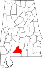 Map of Alabama highlighting Conecuh County | |
| Towns | ||
| Unincorporated communities | ||
| Footnotes | ‡This populated place also has portions in an adjacent county or counties | |
This article is issued from Wikipedia. The text is licensed under Creative Commons - Attribution - Sharealike. Additional terms may apply for the media files.