Kretinga District Municipality
Kretingos rajono savivaldybė | |
|---|---|
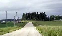 Landscape near Rūdaičiai | |
 Coat of arms | |
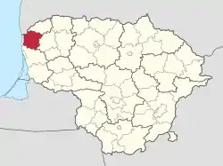 Location of Kretinga district municipality within Lithuania | |
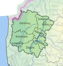 Map of Kretinga district municipality | |
| Country | |
| Ethnographic region | Samogitia |
| County | |
| Established | 1950 |
| Capital | Kretinga |
| Elderships | 8 |
| Government | |
| • Mayor | Antanas Kalnius (2019–) |
| Area | |
| • Total | 989 km2 (382 sq mi) |
| • Rank | 39th |
| Population (2021)[1] | |
| • Total | 37,639 |
| • Rank | 22nd |
| • Density | 38/km2 (99/sq mi) |
| • Rank | 15th |
| Time zone | UTC+2 (EET) |
| • Summer (DST) | UTC+3 (EEST) |
| Telephone code | 445 |
| Major settlements | |
| Website | www |
Kretinga District Municipality is one of 60 municipalities in Lithuania.
Locations in Kretinga District Municipality
Elderships
Kretinga District Municipality is divided into 9 elderships:
| Eldership (Administrative Center) | Area | Population (2021) |
|---|---|---|
| 327 km2 (80,803.46 acres; 126.26 sq mi) | 3,863 | |
| 149.2 km2 (36,868.12 acres; 57.61 sq mi) | 1,689 | |
| 85.4 km2 (21,102.80 acres; 32.97 sq mi) | 1,433 | |
| 15.6 km2 (3,854.84 acres; 6.02 sq mi) | 17,249 | |
| 144.7 km2 (35,756.15 acres; 55.87 sq mi) | 4,849 | |
| Kulupėnai (Kulupėnai) | 69 km2 (17,050.27 acres; 26.64 sq mi) | 1,407 |
| 3.2 km2 (790.74 acres; 1.24 sq mi) | 1,272 | |
| Vydmantai (Vydmantai) | 30.4 km2 (7,512.00 acres; 11.74 sq mi) | 2,239 |
| Žalgiris (Raguviškiai) | 164.6 km2 (40,673.55 acres; 63.55 sq mi) | 3,638 |
References
| Municipalities |  | |
|---|---|---|
| Cities | ||
| Towns | ||
| Villages | ||
This article is issued from Wikipedia. The text is licensed under Creative Commons - Attribution - Sharealike. Additional terms may apply for the media files.