Karnali Province is one of the seven federal provinces of Nepal.[1] Karnali is the largest province of Nepal with an area of 30,313 km2 (11,704 sq mi). The province occupies 15% of the Nepal landmass in the size and also holds one of the richest genetic biodiversity in the country. National Park and Protected Areas covered the largest part of Karnali Province. It has climatic diversity ranging from the tropical to permanent snow.
This is a district wise list of natural monuments in Karnali Province, Nepal as officially recognized by and available through the website of the Ministry of Culture, Tourism and Civil Aviation, Ministry of Forests and Environment and District coordination committee, Nepal.[2]
Dailekh District
| ID | Name | Type | Location | District | Coordinates | Image |
|---|---|---|---|---|---|---|
| NP-DAI-01 | Bhairab Kunda[3] | Dailekh |  Upload Photo | |||
| NP-DAI-02 | Dhaukhani Cave | Dailekh | Upload Photo | |||
| NP-DAI-03 | Dhaulapada Cave | Dailekh | Upload Photo | |||
| NP-DAI-04 | Dwari Waterfall | Dailekh | Upload Photo | |||
| NP-DAI-05 | Ghoda Lake | Dailekh | Upload Photo | |||
| NP-DAI-06 | Khadigaira Waterfall | Dailekh | Upload Photo | |||
| NP-DAI-07 | Kushapani Waterfall | Dailekh | Upload Photo | |||
| NP-DAI-08 | Lalikada Cave | Dailekh | Upload Photo | |||
| NP-DAI-09 | Lankuri Waterfall | Dailekh | Upload Photo | |||
| NP-DAI-10 | Madan Lake | Dailekh | Upload Photo | |||
| NP-DAI-11 | Nake Cave | Dailekh | Upload Photo |

Dolpa District
| ID | Name | Type | Location | District | Coordinates | Image |
|---|---|---|---|---|---|---|
| NP-DLP-01 | Mount Kanjiroba | Dolpa | 29°13′N 82°23′E / 29.22°N 82.38°E | |||
| NP-DLP-02 | Phoksundo Lake | Dolpa | 29°12′30″N 82°57′30″E / 29.208333°N 82.958333°E | |||
| NP-DLP-03 | Shey Phoksundo National Park | Dolpa | 29°21′N 82°50′E / 29.35°N 82.84°E | Upload Photo | ||
| NP-DLP-04 | Upper Dolpa | Dolpa | Upload Photo |

East Rukum District
Humla District[4]
| ID | Name | Type | Location | District | Coordinates | Image |
|---|---|---|---|---|---|---|
| NP-HUM-01 | Tshom Tsho Lake[5] | Humla | 30°09′N 81°25′E / 30.15°N 81.41°E |  Tshom Tsho Lake[5] | ||
| NP-HUM-02 | Nyalu La Pass[5][6] | Humla | 30°09′N 81°25′E / 30.15°N 81.41°E | Upload Photo | ||
| NP-HUM-03 | Chankheli Mountain[7][8] | Humla | 29°38′N 82°06′E / 29.64°N 82.10°E | Upload Photo | ||
| NP-HUM-04 | Nara La Pass[9] | Humla | 30°05′N 81°12′E / 30.09°N 81.20°E | 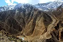 Nara La Pass[10] | ||
| NP-HUM-05 | Seliwaan Dah | Humla | Upload Photo | |||
| NP-HUM-06 | Daaju Lake | Humla | Upload Photo | |||
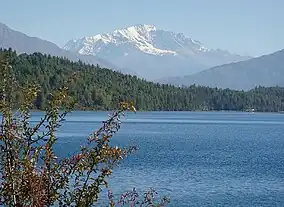
| NP-HUM-07 | Panchamukhi Mountain | Humla | 30°17′N 81°28′E / 30.29°N 81.47°E |  Panchamukhi Mountain | ||
| NP-HUM-08 | Namka La Pass[11] | Humla | Upload Photo | |||
| NP-HUM-09 | Selima Tso Lake | Humla | 30°16′N 81°41′E / 30.26°N 81.68°E | Upload Photo | ||
| NP-HUM-10 | Nauchare Falls | Humla |  Nauchare Falls |
Jajarkot District
Nadai Daab, Chalna Daab, Sai Kuwari lek are the natural monuments in Jajarkot.
Jumla District[12]
| ID | Name | Type | Location | District | Coordinates | Image |
|---|---|---|---|---|---|---|
| NP-JUM-01 | Dansaghu Dobhan | Jumla | 29°19′N 81°59′E / 29.32°N 81.98°E |  Dansaghu Dobhan | ||
| NP-JUM-02 | Pandava Cave | Jumla | Upload Photo | |||
| NP-JUM-03 | Sinja Valley[13] | Jumla | 29°11′N 81°35′E / 29.19°N 81.58°E | |||
| NP-JUM-04 | Tatopani | Jumla | 29°14′N 82°03′E / 29.24°N 82.05°E | |||
| NP-JUM-05 | Tila Valley | Jumla |  Tila Valley |


Kalikot District[15]
| ID | Name | Type | Location | District | Coordinates | Image |
|---|---|---|---|---|---|---|
| NP-KAL-01 | Dhunge Bagaicha | Kalikot | Upload Photo | |||
| NP-KAL-02 | Lake Daha | Kalikot | Upload Photo | |||
| NP-KAL-03 | Pachachhahari Waterfall | Kalikot | Upload Photo | |||
| NP-KAL-04 | Pachal Waterfall[16] | Kalikot | Upload Photo | |||
| NP-KAL-05 | Pan Daha | Kalikot | Upload Photo | |||
| NP-KAL-06 | Phugadh Waterfall | Kalikot | Upload Photo | |||
| NP-KAL-07 | Rakherwada Daha | Kalikot | Upload Photo | |||
| NP-KAL-08 | Tila Cave[17] | Kalikot | Upload Photo | |||
| NP-KAL-09 | Tridevi Lake | Kalikot | Upload Photo |
Mugu District[18]
| ID | Name | Type | Location | District | Coordinates | Image |
|---|---|---|---|---|---|---|
| NP-MUG-01 | Rara Lake | Mugu | 29°19′N 82°03′E / 29.31°N 82.05°E | |||
| NP-MUG-02 | Rara National Park[19] | Mugu | 29°18′N 82°02′E / 29.30°N 82.03°E | |||
| NP-MUG-03 | Saipal | Mugu | 29°32′N 81°17′E / 29.53°N 81.29°E |


| ID | Name | Location | Coordinate | Image | Features |
|---|---|---|---|---|---|
| NP-SAL-01 | Kupinde Daha (lake) | Bangadh Kupinde Na.Pa. | Example | Example | |
| NP-SAL-02 | Khairabang Bhagawati Mandir | Example | Example | Example | Example |
| NP-SAL-03 | Kachhuwa Daha | Kalimati Ga.Pa. | Example | Example | Example |
| NP-SAL-04 | Kumakh Lek and Kumakhi Mai | Kumakh Ga.Pa. | Example | Example | Example |
| NP-SAL-05 | Chhatreshwari Temple | Chhatreshwari Ga.Pa. | Example | Example | Example |
| NP-SAL-06 | Example | Example | Example | Example | Example |
| NP-SAL-07 | Example | Example | Example | Example | Example |
| NP-SAL-08 | Example | Example | Example | Example | Example |
| NP-SAL-09 | Example | Example | Example | Example | Example |
| NP-SAL-10 | Example | Example | Example | Example | Example |
Salyan District
Surkhet District[21]
| ID | Name | Type | Location | District | Coordinates | Image |
|---|---|---|---|---|---|---|
| NP-SUR-01 | Baraha Lake[22] | Baraha Rural Municipality | Surkhet | 28°12′N 82°17′E / 28.20°N 82.29°E | Upload Photo | |
| NP-SUR-02 | Bulbule Lake[23] | Birendranagar | Surkhet | 28°35′N 81°37′E / 28.58°N 81.61°E | ||
| NP-SUR-03 | Jajura Lake | Bidyapur | Surkhet | 28°49′N 81°22′E / 28.82°N 81.37°E | Upload Photo |

Western Rukum District
| ID | Name | Type | Location | District | Coordinates | Image |
|---|---|---|---|---|---|---|
| NP-WRUK-01 | Dajire Lake | Banfikot | Rukum | Upload Photo | ||
| NP-WRUK-02 | Khara Lake | Tribeni | Rukum | Upload Photo | ||
| NP-WRUK-03 | Sital Pokhari | Khalanga | Rukum | Upload Photo | ||
| NP-WRUK-04 | Sankha Lake | Tribeni | Rukum | Upload Photo | ||
| NP-WRUK-05 | Syarpu lake[25] | Banfikot | Rukum | 28°41′N 82°28′E / 28.69°N 82.47°E |

See also
References
- ↑ "Nepal Provinces". statoids.com. Retrieved 2016-03-21.
- ↑ Ministry of Environment and Forests: "Report of Protected forests"
- ↑ केसी, गोविन्द. "पञ्चकोशी क्षेत्र" (in Nepali).
- ↑ "हुम्ला जि.स.स". www.ddchumla.gov.np (in Nepali). Retrieved 2018-05-19.
- 1 2 3 "About Humla". www.namkhyung.org. Retrieved 2018-05-19.
- ↑ "भञ्ज्याङको उकालो" (in Nepali). Retrieved 2018-05-19.
- ↑ "रारा जाँदा भुल्नै नहुने चंखेली हिमाल !". ujyaaloonline.com. Retrieved 2018-05-19.
- ↑ "Bliss of Karnali: Myths and realities". The Himalayan Times. 2017-06-30. Retrieved 2018-05-19.
- ↑ "Nara La". www.dangerousroads.org. Retrieved 2018-05-19.
- ↑ "Nara La". www.dangerousroads.org. Retrieved 2018-05-19.
- ↑ "8 things to do in Simikot. (Humla)". ghumgham.com. Retrieved 2018-05-19.
- ↑ "जुम्ला जि.स.स". www.ddcjumla.gov.np (in Nepali). Retrieved 2018-05-19.
- ↑ Centre, UNESCO World Heritage. "Sinja valley - UNESCO World Heritage Centre". whc.unesco.org. Retrieved 2018-05-19.
- ↑ Centre, UNESCO World Heritage. "Sinja valley - UNESCO World Heritage Centre". whc.unesco.org. Retrieved 2018-05-19.
- ↑ "कालिकोट जि.स.स". www.ddckalikot.gov.np (in Nepali). Retrieved 2018-05-19.
- ↑ "Province 6 adopts 21-point declaration". The Himalayan Times. 2017-06-24. Retrieved 2018-05-19.
- ↑ "पर्यटन वर्ष सफल पार्न स्थानीय सरकार सक्रिय". Retrieved 2018-05-19.
- ↑ "मुगु जि.स.स". www.ddcmugu.gov.np (in Nepali). Retrieved 2018-05-19.
- ↑ "Rara National Park: Potential touristic hub - The Himalayan Times". The Himalayan Times. 2016-05-26. Retrieved 2018-05-19.
- ↑ "Rara National Park: Potential touristic hub - The Himalayan Times". The Himalayan Times. 2016-05-26. Retrieved 2018-05-19.
- ↑ "सुर्खेत जि.स.स". www.ddcsurkhet.gov.np (in Nepali). Retrieved 2018-05-19.
- ↑ "सुर्खेतको ठूलो ताल सुक्न थाल्यो". देशसञ्चार (in Nepali). 2018-03-26. Retrieved 2018-05-19.
- ↑ "Bulbule Lake". birendranagarmun.gov.np. Retrieved 2018-05-19.
- ↑ "Bulbule Lake". birendranagarmun.gov.np. Retrieved 2018-05-19.
- ↑ "Observation tower set up at Syarpu lake". therisingnepal.org.np. Retrieved 2018-05-19.
- ↑ "Observation tower set up at Syarpu lake". therisingnepal.org.np. Retrieved 2018-05-19.