Le Rocher-Percé | |
|---|---|
 | |
| Coordinates: 48°22′N 64°37′W / 48.367°N 64.617°W[1] | |
| Country | |
| Province | |
| Region | Gaspésie–Îles-de-la-Madeleine |
| Effective | April 1, 1981 |
| County seat | Chandler |
| Government | |
| • Type | Prefecture |
| • Prefect | Samuel Parisé |
| Area | |
| • Total | 3,249.20 km2 (1,254.52 sq mi) |
| • Land | 3,076.80 km2 (1,187.96 sq mi) |
| Population (2016)[3] | |
| • Total | 17,282 |
| • Density | 5.6/km2 (15/sq mi) |
| • Change 2011-2016 | |
| • Dwellings | 8,969 |
| Time zone | UTC−5 (EST) |
| • Summer (DST) | UTC−4 (EDT) |
| Area code(s) | 418 and 581 |
| Website | www |
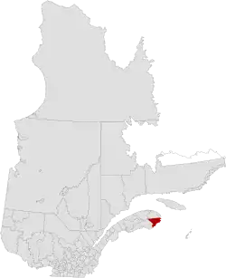
Rocher-Percé is a regional county municipality in the Gaspésie–Îles-de-la-Madeleine region of Quebec, Canada. Its seat is Chandler. Prior to July 17, 1999 it was known as Pabok Regional County Municipality.[4]
It is named after Percé Rock (the pierced rock), a massive arched sandstone rock rising from the Atlantic just off the tip of the Gaspé peninsula. The region includes the towns of Percé, Grande-Rivière, Port-Daniel–Gascons and Chandler. Major tourist attractions include the Percé Rock and Bonaventure Island.
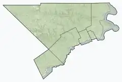
Subdivisions
There are 6 subdivisions within the RCM:[2]
|
|
|
Demographics
Population
Canada census – Le Rocher-Percé community profile
| 2021 | 2016 | 2011 | |
|---|---|---|---|
| Population | 17,219 (-0.4% from 2016) | 17,282 (-3.9% from 2011) | 17,979 (-2.5% from 2006) |
| Land area | 3,074.80 km2 (1,187.19 sq mi) | 3,076.80 km2 (1,187.96 sq mi) | 3,077.81 km2 (1,188.35 sq mi) |
| Population density | 5.6/km2 (15/sq mi) | 5.6/km2 (15/sq mi) | 5.8/km2 (15/sq mi) |
| Median age | 56.0 (M: 55.2, F: 57.2) | 53.9 (M: 53.2, F: 54.7) | 50.6 (M: 50.0, F: 51.3) |
| Private dwellings | 9,110 (total) 8,319 (occupied) | 8,969 (total) | 8,622 (total) |
| Median household income | $59,600 | $47,957 | $38,549 |
|
| ||||||||||||||||||||||||
| [10][11][3] | |||||||||||||||||||||||||
Language
| Canada Census Mother Tongue - Le Rocher-Percé Regional County Municipality, Quebec[10] | ||||||||||||||||||
|---|---|---|---|---|---|---|---|---|---|---|---|---|---|---|---|---|---|---|
| Census | Total | French |
English |
French & English |
Other | |||||||||||||
| Year | Responses | Count | Trend | Pop % | Count | Trend | Pop % | Count | Trend | Pop % | Count | Trend | Pop % | |||||
2016 |
17,100 |
15,680 | 91.7% | 1,235 | 7.2% | 110 | 0.6% | 75 | 0.4% | |||||||||
2011 |
17,870 |
16,325 | 91.35% | 1,385 | 7.75% | 115 | 0.64% | 45 | 0.25% | |||||||||
2006 |
18,265 |
16,675 | 91.29% | 1,315 | 7.20% | 30 | 0.16% | 245 | 1.34% | |||||||||
2001 |
19,170 |
17,620 | 91.91% | 1,430 | 7.46% | 90 | 0.47% | 30 | 0.16% | |||||||||
1996 |
21,230 |
19,315 | n/a | 90.98% | 1,655 | n/a | 7.80% | 225 | n/a | 1.06% | 35 | n/a | 0.16% | |||||
Transportation
Access Routes
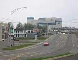
.jpg.webp)
Quebec Route 132 near Percé
Highways and numbered routes that run through the municipality, including external routes that start or finish at the county border:[12]
|
|
|
|
See also
References
- ↑ "Banque de noms de lieux du Québec: Reference number 351206". toponymie.gouv.qc.ca (in French). Commission de toponymie du Québec.
- 1 2 3 "Répertoire des municipalités: Geographic code 020". www.mamh.gouv.qc.ca (in French). Ministère des Affaires municipales et de l'Habitation.
- 1 2 3 "Census Profile, 2016 Census: Le Rocher-Percé, Municipalité régionale de comté [Census division], Quebec". Statistics Canada. Retrieved November 29, 2019.
- ↑ "Archived copy" (PDF). stat.gouv.qc.ca. Archived from the original (PDF) on 30 December 2006. Retrieved 22 May 2022.
{{cite web}}: CS1 maint: archived copy as title (link) - ↑ "2021 Community Profiles". 2021 Canadian Census. Statistics Canada. February 4, 2022. Retrieved 2023-10-19.
- ↑ "2016 Community Profiles". 2016 Canadian Census. Statistics Canada. August 12, 2021. Retrieved 2019-11-29.
- ↑ "2011 Community Profiles". 2011 Canadian Census. Statistics Canada. March 21, 2019. Retrieved 2014-04-20.
- ↑ "2006 Community Profiles". 2006 Canadian Census. Statistics Canada. August 20, 2019.
- ↑ "2001 Community Profiles". 2001 Canadian Census. Statistics Canada. July 18, 2021.
- 1 2 Statistics Canada: 1996, 2001, 2006, 2011 census
- ↑ "Le Rocher-Percé Regional County Municipality (Code 2402) Census Profile". 2011 census. Government of Canada - Statistics Canada.
- ↑ Official Transport Quebec Road Map
Adjacent Counties & Equivalent Territories | |
|---|---|
| Regional county municipalities and equivalent territories | |
|---|---|
| Municipalities | |
This article is issued from Wikipedia. The text is licensed under Creative Commons - Attribution - Sharealike. Additional terms may apply for the media files.