Prienai District Municipality
Prienų rajono savivaldybė | |
|---|---|
 Landscape example | |
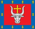
 Coat of arms | |
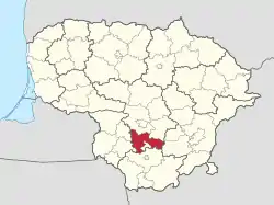 Location of Prienai district municipality within Lithuania | |
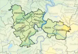 Map of Prienai district municipality | |
| Country | |
| Ethnographic region | Dzūkija / Suvalkija |
| County | |
| Capital | Prienai |
| Elderships | 10 |
| Area | |
| • Total | 1,031 km2 (398 sq mi) |
| • Rank | 38th |
| Population | |
| • Total | 25,286 |
| • Rank | 33rd |
| • Density | 25/km2 (64/sq mi) |
| • Rank | 27th |
| Time zone | UTC+2 (EET) |
| • Summer (DST) | UTC+3 (EEST) |
| Telephone code | 319 |
| Major settlements |
|
| Website | www |
Prienai District Municipality is one of 60 municipalities in Lithuania. It was a member of the European Union-wide town twinning association Douzelage from 2008 to 2018.
References
54°40′19″N 23°57′40″E / 54.67194°N 23.96111°E
This article is issued from Wikipedia. The text is licensed under Creative Commons - Attribution - Sharealike. Additional terms may apply for the media files.