| Schwarza | |
|---|---|
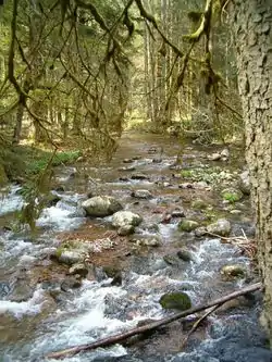 The Schwarza between the Witznau reservoir and "Leinegg" (latter at the confluence with Fohrenbach creek) | |
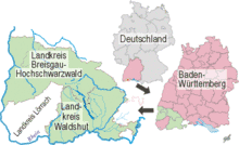 Map of the location of the Schwarza in Germany, Baden-Württemberg, and in and near the Districts (Singular in German: Landkreis) of Bresigau-Hochschwarzwald, Waldshut und Lörrach | |
| Location | |
| Country | Germany |
| State | Baden-Württemberg |
| Districts | |
| Physical characteristics | |
| Source | Schluchsee |
| • location | Schluchsee Municipality, Breisgau-Hochschwarzwald District |
| • coordinates | 47°48′01″N 8°11′00″E / 47.80028°N 8.18333°E |
| • elevation | 890 m (2,920 ft) |
| Mouth | Schlücht |
• location | Witznau, Ühlingen-Birkendorf, Waldshut District |
• coordinates | 47°40′44″N 8°15′20″E / 47.67889°N 8.25556°E |
• elevation | 427 m (1,401 ft) |
| Length | 18.4 km (11.4 mi) |
| Basin size | 112 km2 (43 sq mi) |
| Basin features | |
| River system | Rhine drainage basin |
| Progression | Schlücht→ Wutach→ Rhine→ North Sea |
The Schwarza is a river in the districts of Waldshut and Breisgau-Hochschwarzwald in Baden-Württemberg, Germany. It is in the Rhine drainage basin and is a right tributary of the Schlücht.
See also
This article is issued from Wikipedia. The text is licensed under Creative Commons - Attribution - Sharealike. Additional terms may apply for the media files.