Walldorf | |
|---|---|
 | |
.png.webp) Coat of arms | |
Location of Walldorf | |
 Walldorf 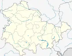 Walldorf | |
| Coordinates: 50°37′N 10°23′E / 50.617°N 10.383°E | |
| Country | Germany |
| State | Thuringia |
| District | Schmalkalden-Meiningen |
| Town | Meiningen |
| Area | |
| • Total | 12.16 km2 (4.70 sq mi) |
| Elevation | 290 m (950 ft) |
| Population (2017-12-31) | |
| • Total | 2,164 |
| • Density | 180/km2 (460/sq mi) |
| Time zone | UTC+01:00 (CET) |
| • Summer (DST) | UTC+02:00 (CEST) |
| Postal codes | 98639 |
| Dialling codes | 03693 |
| Website | www.walldorf-werra.de |
Walldorf is a village and a former municipality the district of Schmalkalden-Meiningen in Thuringia, Germany. Since 1 January 2019, it is part of the town Meiningen.
Its most notable sight is a fortress church, Kirchenburg Walldorf, in the middle of town on a hill. In April 2012 it was heavily damaged in a fire.
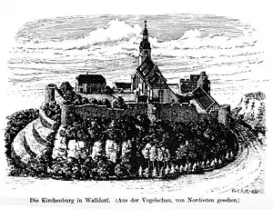
Kirchenburg (fortified church) Walldorf, idealized, by G. Lilie 1904

The burning of Kirchenburg Walldorf, April 2012
References
This article is issued from Wikipedia. The text is licensed under Creative Commons - Attribution - Sharealike. Additional terms may apply for the media files.