Albemarle and Chesapeake Canal Historic District | |
.jpg.webp) The Great Bridge over the Canal | |
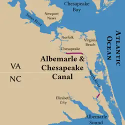
 Path of the canal | |
| Location | Albemarle and Chesapeake Canal, Chesapeake (Independent city), Virginia |
|---|---|
| Coordinates | 36°43′34″N 76°6′33″W / 36.72611°N 76.10917°W |
| Area | 1,704 acres (690 ha) |
| Built | 1775 |
| NRHP reference No. | 04000035[1] |
| VLR No. | 131-5333 |
| Significant dates | |
| Added to NRHP | February 11, 2004 |
| Designated VLR | December 3, 2002[2] |
The Albemarle and Chesapeake Canal was built by a corporation in 1856-1860 to afford inland navigation between the Chesapeake Bay and the Albemarle Sound. It is really two canals, thirty miles (50 km) apart, one eight and one-half miles (13.7 km) long, connecting the Elizabeth River with the North Landing River in Virginia, and the other five and one-half miles (8.9 km) long, connecting the Currituck Sound with the North River in North Carolina.[3]
It was listed on the National Register of Historic Places in 2003.[1]
Sources
- Dictionary of American History, by James Truslow Adams, New York: Charles Scribner's Sons, 1940
References
- 1 2 "National Register Information System". National Register of Historic Places. National Park Service. March 13, 2009.
- ↑ "Virginia Landmarks Register". Virginia Department of Historic Resources. Archived from the original on September 21, 2013. Retrieved June 5, 2013.
- ↑ Geoffrey Henry (July 2003). "National Register of Historic Places Inventory/Nomination: Albemarle and Chesapeake Canal" (PDF). Virginia Department of Historic Resources. Archived from the original (PDF) on February 10, 2017. Retrieved May 11, 2019. and Accompanying four photos Archived 2017-08-18 at the Wayback Machine and Accompanying maps Archived 2013-08-13 at the Wayback Machine
This article is issued from Wikipedia. The text is licensed under Creative Commons - Attribution - Sharealike. Additional terms may apply for the media files.

