Albia, Iowa | |
|---|---|
 | |
 Location within Monroe County and Iowa | |
| Coordinates: 41°01′35″N 92°48′14″W / 41.02639°N 92.80389°W | |
| Country | United States |
| State | Iowa |
| County | Monroe |
| Area | |
| • Total | 3.23 sq mi (8.37 km2) |
| • Land | 3.23 sq mi (8.37 km2) |
| • Water | 0.00 sq mi (0.00 km2) |
| Elevation | 961 ft (293 m) |
| Population (2020) | |
| • Total | 3,721 |
| • Density | 1,151.30/sq mi (444.50/km2) |
| Time zone | UTC-6 (Central (CST)) |
| • Summer (DST) | UTC-5 (CDT) |
| ZIP code | 52531 |
| Area code | 641 |
| FIPS code | 19-00910 |
| GNIS feature ID | 2393905[2] |
| Website | www |
Albia is a city in and the county seat of Monroe County, in southern Iowa, United States.[3] The population was 3,721 at the 2020 census.[4]
The city of Albia is known for its historic square and city-wide Victorian Architecture. Albia is also known for the annual "Restoration" days celebration which commemorates the refurbishment of the square and the town which began in the mid-1960s.[5]
History


Albia was incorporated as a town in 1856.[6] The town was named after Albia, New York, the former home of an early settler.[7]
On Feb. 14, 1893, there was a coal mine explosion in the Chicago and Iowa mine, about 2.5 miles west of Albia. This room and pillar mine had opened around 1877. By the time of the explosion, mining extended more than 1,000 yards from the hoisting shaft, and the mine employed 60 miners and 20 other men. One miner was killed outright and seven died later of their injuries, after a "shot" (gunpowder charge used to bring down the coal) ignited a dust explosion in the mine. This was one of only two major mine disasters in Iowa between 1888 and 1913.[8][9]
In the early 20th century, the region around Albia was dotted with coal mining camps and company towns. Of these, Buxton, 9 miles north of Albia, is the most widely studied. It had a large Black population.[10] Other former coal camps in the area include Hiteman, Bluff Creek, Lockman, Coalfield, Hocking, and Hynes.
The growth in membership in the United Mine Workers union, as shown by the following data, is a useful measure of the importance of mining in the region. In 1902, UMW Locals 692 and 793 in Albia had an aggregate membership of 216. By 1912, UMW Locals 407, 782 and 793 in Albia had an aggregate membership of 338 (about 7.2% of the 1910 population). Miners in Hiteman, 5 miles northwest of town, joined the UMWA in 1898; between 1902 and 1912, membership grew from 450 to 688. Miners in Hynes, 7 miles east, joined the UMWA in 1896; between 1902 and 1912, membership grew from 330 to 543.[11][12]
Geography
According to the United States Census Bureau, the city has a total area of 3.19 square miles (8.26 km2), all land.[13]
Climate
According to the Köppen Climate Classification system, Albia has a hot-summer humid continental climate, abbreviated "Dfa" on climate maps.
| Climate data for Albia, Iowa (elev. 880 feet), 1991–2020 normals, extremes 1894–present | |||||||||||||
|---|---|---|---|---|---|---|---|---|---|---|---|---|---|
| Month | Jan | Feb | Mar | Apr | May | Jun | Jul | Aug | Sep | Oct | Nov | Dec | Year |
| Record high °F (°C) | 71 (22) |
79 (26) |
90 (32) |
93 (34) |
104 (40) |
105 (41) |
110 (43) |
113 (45) |
104 (40) |
96 (36) |
82 (28) |
71 (22) |
113 (45) |
| Mean maximum °F (°C) | 55.1 (12.8) |
59.4 (15.2) |
73.2 (22.9) |
81.2 (27.3) |
86.0 (30.0) |
90.3 (32.4) |
94.2 (34.6) |
93.8 (34.3) |
89.6 (32.0) |
82.6 (28.1) |
70.2 (21.2) |
58.9 (14.9) |
96.0 (35.6) |
| Mean daily maximum °F (°C) | 31.3 (−0.4) |
35.9 (2.2) |
48.7 (9.3) |
61.4 (16.3) |
70.9 (21.6) |
80.2 (26.8) |
84.4 (29.1) |
82.8 (28.2) |
76.0 (24.4) |
63.4 (17.4) |
49.0 (9.4) |
36.5 (2.5) |
60.0 (15.6) |
| Daily mean °F (°C) | 22.2 (−5.4) |
26.3 (−3.2) |
38.3 (3.5) |
50.1 (10.1) |
60.7 (15.9) |
70.4 (21.3) |
74.5 (23.6) |
72.6 (22.6) |
64.8 (18.2) |
52.6 (11.4) |
39.2 (4.0) |
27.9 (−2.3) |
50.0 (10.0) |
| Mean daily minimum °F (°C) | 13.2 (−10.4) |
16.8 (−8.4) |
28.0 (−2.2) |
38.8 (3.8) |
50.5 (10.3) |
60.6 (15.9) |
64.6 (18.1) |
62.4 (16.9) |
53.5 (11.9) |
41.8 (5.4) |
29.5 (−1.4) |
19.3 (−7.1) |
39.9 (4.4) |
| Mean minimum °F (°C) | −9.0 (−22.8) |
−4.1 (−20.1) |
7.1 (−13.8) |
24.1 (−4.4) |
35.1 (1.7) |
47.1 (8.4) |
53.3 (11.8) |
51.2 (10.7) |
37.7 (3.2) |
25.8 (−3.4) |
12.2 (−11.0) |
−1.6 (−18.7) |
−12.8 (−24.9) |
| Record low °F (°C) | −29 (−34) |
−31 (−35) |
−15 (−26) |
8 (−13) |
21 (−6) |
37 (3) |
41 (5) |
36 (2) |
22 (−6) |
5 (−15) |
−8 (−22) |
−26 (−32) |
−31 (−35) |
| Average precipitation inches (mm) | 1.13 (29) |
1.49 (38) |
2.02 (51) |
3.77 (96) |
4.86 (123) |
5.18 (132) |
4.02 (102) |
4.04 (103) |
3.57 (91) |
2.80 (71) |
2.14 (54) |
1.47 (37) |
36.49 (927) |
| Average snowfall inches (cm) | 7.4 (19) |
8.4 (21) |
3.9 (9.9) |
1.1 (2.8) |
0.0 (0.0) |
0.0 (0.0) |
0.0 (0.0) |
0.0 (0.0) |
0.0 (0.0) |
0.4 (1.0) |
1.9 (4.8) |
6.9 (18) |
30 (76.5) |
| Average precipitation days (≥ 0.01 in) | 6.6 | 7.3 | 8.3 | 10.8 | 12.4 | 11.7 | 8.9 | 9.1 | 7.8 | 8.4 | 6.8 | 7.0 | 105.1 |
| Average snowy days (≥ 0.1 in) | 4.3 | 4.4 | 2.1 | 0.4 | 0.0 | 0.0 | 0.0 | 0.0 | 0.0 | 0.2 | 1.1 | 3.7 | 16.2 |
| Source 1: NOAA[14] | |||||||||||||
| Source 2: National Weather Service[15] | |||||||||||||
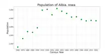
Demographics
| Year | Pop. | ±% |
|---|---|---|
| 1860 | 620 | — |
| 1870 | 1,621 | +161.5% |
| 1880 | 2,435 | +50.2% |
| 1890 | 2,359 | −3.1% |
| 1900 | 2,889 | +22.5% |
| 1910 | 4,969 | +72.0% |
| 1920 | 5,067 | +2.0% |
| 1930 | 4,425 | −12.7% |
| 1940 | 5,157 | +16.5% |
| 1950 | 4,838 | −6.2% |
| 1960 | 4,582 | −5.3% |
| 1970 | 4,151 | −9.4% |
| 1980 | 4,184 | +0.8% |
| 1990 | 3,870 | −7.5% |
| 2000 | 3,706 | −4.2% |
| 2010 | 3,766 | +1.6% |
| 2020 | 3,721 | −1.2% |
| Iowa Data Center Source: | ||

.jpg.webp)
2010 census
As of the census[17] of 2010, there were 3,766 people, 1,540 households, and 960 families living in the city. The population density was 1,180.6 inhabitants per square mile (455.8/km2). There were 1,763 housing units at an average density of 552.7 per square mile (213.4/km2). The racial makeup of the city was 97.5% White, 0.3% African American, 0.2% Native American, 0.3% Asian, 0.4% from other races, and 1.3% from two or more races. Hispanic or Latino of any race were 1.9% of the population.
There were 1,540 households, of which 30.6% had children under the age of 18 living with them, 45.3% were married couples living together, 11.4% had a female householder with no husband present, 5.7% had a male householder with no wife present, and 37.7% were non-families. 32.5% of all households were made up of individuals, and 15.6% had someone living alone who was 65 years of age or older. The average household size was 2.37 and the average family size was 2.98.
The median age in the city was 40 years. 25.1% of residents were under the age of 18; 8.1% were between the ages of 18 and 24; 22.5% were from 25 to 44; 24.5% were from 45 to 64; and 19.8% were 65 years of age or older. The gender makeup of the city was 48.5% male and 51.5% female.
2000 census
As of the census[18] of 2000, there were 3,706 people, 1,531 households, and 943 families living in the city. The population density was 1,184.8 inhabitants per square mile (457.5/km2). There were 1,708 housing units at an average density of 546.0 per square mile (210.8/km2). The racial makeup of the city was 97.92% White, 0.32% African American, 0.32% Native American, 0.62% Asian, 0.24% from other races, and 0.57% from two or more races. Hispanic or Latino of any race were 0.84% of the population.
There were 1,531 households, out of which 29.8% had children under the age of 18 living with them, 46.8% were married couples living together, 11.5% had a female householder with no husband present, and 38.4% were non-families. 33.9% of all households were made up of individuals, and 19.2% had someone living alone who was 65 years of age or older. The average household size was 2.31 and the average family size was 2.97.
Age spread: 25.1% under the age of 18, 7.9% from 18 to 24, 24.2% from 25 to 44, 19.8% from 45 to 64, and 22.9% who were 65 years of age or older. The median age was 39 years. For every 100 females, there were 85.5 males. For every 100 females age 18 and over, there were 80.5 males.
The median income for a household in the city was $31,728, and the median income for a family was $41,607. Males had a median income of $33,025 versus $20,933 for females. The per capita income for the city was $16,843. About 4.3% of families and 9.2% of the population were below the poverty line, including 10.1% of those under age 18 and 4.7% of those age 65 or over.
Education
Albia Community School District operates public schools serving the community.[19]
Activities
In Albia, there's the "Monroe Aquatic Center", "Washington Park", and the "City Park". The aquatic center has two water slides, low dive, high dive, children's area, basketball hoops above the water, and lockers. The city park includes a basketball court, a baseball field, a tennis court, and a playground with swings.
Notable people
- George Bennard (1873–1958), composer of "The Old Rugged Cross"[20]
- Nathan E. Kendall (1868–1936), politician and U.S. Representative from Iowa's 6th congressional district and the 23rd Governor of Iowa[21]
- John Judge (born 1944), politician, served in the Iowa State Senate[22]
- Patty Judge (born 1943), politician, served Iowa as State Senator, Iowa Secretary of Agriculture, and Lieutenant Governor of Iowa[23]
- Johnny Miler, né Miletich (1910–1976) Boxer, 1932 Summer Olympics. Defeated Joe Louis in amateur bout[24]
- Wendell Nedderman (1921-2019), college administrator, president of The University of Texas at Arlington from 1972 to 1992
- Theodore Bolivar Perry, politician
- James Stevens (1892–1971), musician and writer, most notably Paul Bunyan[25]
- Fred Townsend (1862–1918), politician and Iowa legislator, football player[26]
- Josiah T. Young (1831-1907), politician - Iowa Secretary of State, legislator and newspaper editor; mayor of Albia[27]
References
- ↑ "2020 U.S. Gazetteer Files". United States Census Bureau. Retrieved March 16, 2022.
- 1 2 U.S. Geological Survey Geographic Names Information System: Albia, Iowa
- ↑ "Find a County". National Association of Counties. Archived from the original on May 31, 2011. Retrieved 2011-06-07.
- 1 2 "2020 Census State Redistricting Data". census.gov. United states Census Bureau. Retrieved August 12, 2021.
- ↑ "Albia's 'Restoration Days' gets expanded and re-imagined". Ottumwa Courier. Retrieved August 3, 2022.
- ↑ Hickenlooper, Frank (1896). An Illustrated History of Monroe County, Iowa. F. Hickenlopper. pp. 296.
- ↑ Savage, Tom (August 2007). A Dictionary of Iowa Place-Names. University of Iowa Press. p. 21. ISBN 978-1-58729-759-5.
...in honor of his prior home in New York.
- ↑ Albert H. Fay, Coal-Mine Fatalities in the United States 1870–1914, Department of the Interior, Bureau of Mines, Washington DC, 1916, page 190.
- ↑ Sixth Biennial Report of the State Mine Inspectors to the Governor of the State of Iowa for the Two Years Ending June 30, 1893, Ragsdale, Des Moines, 1893, pages 29–35.
- ↑ David M. Gradwohl and Nancy M. Osborn, Exploring Buried Buxton – Archaeology of an Abandoned Iowa Coal Mining Town with a Large Black Population, University of Iowa Press, 1990.
- ↑ Trade Unions in Iowa – Table No. 1, Mine Workers of America, United, Tenth Biennial Report of the Bureau of Labor Statistics for the State of Iowa, 1901–1902, Murphy, Des Moines, 1903; page 232.
- ↑ Tally Sheet, Proceedings of the 23rd Annual Convention of the United Mine Workers of America Jan. 16 – Feb. 2, 1912, Indianapolis; Volume 2, pages 180A-185A.
- ↑ "US Gazetteer files 2010". United States Census Bureau. Archived from the original on January 12, 2012. Retrieved 2012-05-11.
- ↑ "U.S. Climate Normals Quick Access". National Oceanic and Atmospheric Administration. Retrieved July 23, 2022.
- ↑ "NOAA Online Weather Data". National Weather Service. Retrieved July 23, 2022.
- ↑ "Census of Population and Housing". Census.gov. Retrieved June 4, 2015.
- ↑ "U.S. Census website". United States Census Bureau. Retrieved May 11, 2012.
- ↑ "U.S. Census website". United States Census Bureau. Retrieved 2008-01-31.
- ↑ "Albia." Iowa Department of Education. Retrieved on June 18, 2018.
- ↑ "The Cyber Hymnal". People – Bennard. Archived from the original on March 4, 2012. Retrieved December 8, 2010.
- ↑ Michael Kramme, "Governors of Iowa," 63–64 (The Iowan Books: 2006)
- ↑ Iowa General Assembly-John Judge
- ↑ "The Iowa Legislature". Legislators All Years – Patty Judge. Archived from the original on April 2, 2012. Retrieved December 8, 2010.
- ↑ "Johnny Miler". SPORTS-REFERENCE/Olympic sports. Archived from the original on April 18, 2020. Retrieved March 12, 2011.
- ↑ "James Stevens papers". University of Washington Libraries. February 2, 2010. Archived from the original on June 11, 2011. Retrieved May 31, 2011.
- ↑ "Frederick Townsend". The Iowa Legislature. Archived from the original on April 19, 2012. Retrieved June 28, 2011.
- ↑ 'A Noble Life Ended,' The Albia Union (Iowa), November 15, 1907, pg. 3
External links
- Albia Chamber of Commerce
- Albia school district website Archived December 3, 2021, at the Wayback Machine