Aleosan | |
|---|---|
| Municipality of Aleosan | |
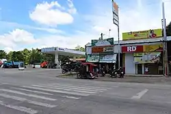 Portion of Barangay Dualing | |
 Flag  Seal | |
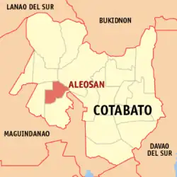 Map of Cotabato with Aleosan highlighted | |
OpenStreetMap | |
.svg.png.webp) Aleosan Location within the Philippines | |
| Coordinates: 7°09′31″N 124°34′32″E / 7.15855°N 124.575436°E | |
| Country | Philippines |
| Region | Soccsksargen |
| Province | Cotabato |
| District | 1st district |
| Founded | April 6, 1982 |
| Barangays | 19 (see Barangays) |
| Government | |
| • Type | Sangguniang Bayan |
| • Mayor | Eduardo C. Cabaya |
| • Vice Mayor | Felimon C. Cayang, Jr. |
| • Representative | Joselito S. Sacdalan |
| • Electorate | 22,457 voters (2022) |
| Area | |
| • Total | 199.409 km2 (76.992 sq mi) |
| Elevation | 47 m (154 ft) |
| Highest elevation | 208 m (682 ft) |
| Lowest elevation | 3 m (10 ft) |
| Population (2020 census)[3] | |
| • Total | 36,892 |
| • Density | 190/km2 (480/sq mi) |
| • Households | 8,646 |
| Economy | |
| • Income class | 3rd municipal income class |
| • Poverty incidence | 47.10 |
| • Revenue | ₱ 161 million (2020) |
| • Assets | ₱ 419.5 million (2020) |
| • Expenditure | ₱ 139.2 million (2020) |
| • Liabilities | ₱ 211 million (2020) |
| Service provider | |
| • Electricity | Cotabato Electric Cooperative (COTELCO) |
| Time zone | UTC+8 (PST) |
| ZIP code | 9415 |
| PSGC | |
| IDD : area code | +63 (0)64 |
| Native languages | Hiligaynon Cebuano Maguindanao Ilianen Tagalog |
| Website | www |
Aleosan, officially the Municipality of Aleosan (Maguindanaon: Inged nu Aleosan, Jawi: ايڠد نو الاوسن; Iranun: Inged a Aleosan, ايڠد ا الاوسن; Hiligaynon: Banwa sang Aleosan; Cebuano: Lungsod sa Aleosan; Tagalog: Bayan ng Aleosan), is a 3rd class municipality in the province of Cotabato, Philippines. According to the 2020 census, it has a population of 36,892 people.[3]
History
The name Aleosan is an acronym derived from the three (3) towns of Iloilo where majority of the early Christian settlers came from; A is for Alimodian, LEO is for Leon, and SAN for San Miguel.[5]
Parliamentary bill no. 670 authored by Assemblyman Jesus P. Amparo and co-authored by assemblymen Blah T. Sinsuat, Ernesto F. Roldan and Tomas B. Baga Jr. sought to establish and create the Municipality of Aleosan in the Province of Cotabato, which was ultimately approved and signed into law Batas Pambansa bilang 206 on April 6, 1982. For purposes of ratification, Proclamation No. 2188 was signed by President Ferdinand E. Marcos on April 29, 1982. A plebiscite was conducted on May 7, 1982, which was unanimously confirmed the desire and aspiration of the people in the nineteen (19) barangays to become a distinct and regular municipality from Pikit its mother municipality.
Geography
Aleosan is within the political boundary of Cotabato Province. It is approximately 65 kilometres (40 mi) from the capital town of Amas which is barely two (2) hours ride from the seat of its municipal government. It is bounded on the west by Midsayap; on the north by Libungan and on the east and south by Pikit. It is accessible to land transportation from Cotabato City traversing the municipalities of Maguindanao to Kidapawan up to Davao City, as it is located along the major transport route linking the provinces of Maguindanao, Cotabato and Davao del Sur.
Barangays
Aleosan is politically subdivided into 19 barangays. [6] Each barangay consists of puroks while some have sitios.
The seat of the municipal government is in barangay San Mateo.
- Bagolibas
- Cawilihan
- Dualing
- Dunguan[lower-roman 1]
- Katalicanan
- Lawili
- Lower Mingading
- Luanan
- Malapang
- New Leon
- New Panay
- Pagangan
- Palacat
- Pentil
- San Mateo (Poblacion)
- Santa Cruz
- Tapodoc[lower-roman 1]
- Tomado
- Upper Mingading
- Note
- 1 2 - 2 barangays in Aleosan forms part of the Special Geographic Area of Bangsamoro region despite Cotabato and Aleosan not being under the administrative jurisdiction of the autonomous region. It was partitioned from Soccsksargen following the two-part plebiscite held in January and February 2019. The Bangsamoro's Development Coordinating Office (DCO) oversees the barangays' affairs.[lower-roman 2]
- "BARMM creates office to administer 63 barangays in North Cotabato". bangsamoro.gov.ph. June 30, 2020. Retrieved June 30, 2020.
Climate
| Climate data for Aleosan, Cotabato | |||||||||||||
|---|---|---|---|---|---|---|---|---|---|---|---|---|---|
| Month | Jan | Feb | Mar | Apr | May | Jun | Jul | Aug | Sep | Oct | Nov | Dec | Year |
| Mean daily maximum °C (°F) | 31 (88) |
32 (90) |
33 (91) |
33 (91) |
32 (90) |
31 (88) |
30 (86) |
31 (88) |
31 (88) |
31 (88) |
31 (88) |
31 (88) |
31 (89) |
| Mean daily minimum °C (°F) | 21 (70) |
21 (70) |
21 (70) |
22 (72) |
23 (73) |
23 (73) |
23 (73) |
23 (73) |
23 (73) |
23 (73) |
22 (72) |
22 (72) |
22 (72) |
| Average precipitation mm (inches) | 19 (0.7) |
14 (0.6) |
15 (0.6) |
18 (0.7) |
33 (1.3) |
42 (1.7) |
44 (1.7) |
42 (1.7) |
30 (1.2) |
31 (1.2) |
28 (1.1) |
17 (0.7) |
333 (13.2) |
| Average rainy days | 6.9 | 5.6 | 6.9 | 8.1 | 15.1 | 17.5 | 17.8 | 18.5 | 14.9 | 14.9 | 12.4 | 8.0 | 146.6 |
| Source: Meteoblue[7] | |||||||||||||
Aleosan area belongs to the fourth type of climate or the intermediate "E" with no distinct dry season. Rainfall is evenly distributed throughout the year with heavier rains from May to September. This type of climate conditions is suitable for the production of crops like rice, corn, mangoes, jackfruit, vegetables and root crops, which are considered seasonal crops and permanent crops like coconut, rubber, coffee, cacao and orchard crops.
Demographics
| Year | Pop. | ±% p.a. |
|---|---|---|
| 1990 | 22,574 | — |
| 1995 | 25,408 | +2.24% |
| 2000 | 26,164 | +0.63% |
| 2007 | 32,874 | +3.20% |
| 2010 | 35,746 | +3.09% |
| 2015 | 39,405 | +1.87% |
| 2020 | 36,892 | −1.29% |
| Source: Philippine Statistics Authority[8][9][10][11] 2020 Census count was revised as per PSA Board Resolution No. 13 Series of 2021 adopted on November 9, 2021.[12][13] | ||
In the 2020 census, the population of Aleosan, Cotabato, was 36,892 people,[3] with a density of 160 inhabitants per square kilometre or 410 inhabitants per square mile.
Economy
The municipality is endowed with abundant agricultural raw materials suitable for processing. These include coconut, banana, rubber, mango and coffee. There are small-scale enterprises but these are not sustainable due to inadequate capital. A cassava processing plant was shut down due to insufficient supply of raw materials and low quality of starch produced. The area however, is best suited for mango production and there is a need to develop the industry to cater the growing needs of the locality. The municipality's livestock industry has great potentials being one of the top producers and supplier of livestock in the province.
The Gross Domestic Product of the Municipality (2022) is 7,143,068,857(PHP).
Tourism
- Brgy Malapang – Mountain climbing
- Brgy Pentil – Eco tourism
- Brgy Katalicanan – UK Peak
References
- ↑ Municipality of Aleosan | (DILG)
- ↑ "2015 Census of Population, Report No. 3 – Population, Land Area, and Population Density" (PDF). Philippine Statistics Authority. Quezon City, Philippines. August 2016. ISSN 0117-1453. Archived (PDF) from the original on May 25, 2021. Retrieved July 16, 2021.
- 1 2 3 Census of Population (2020). "Region XII (Soccsksargen)". Total Population by Province, City, Municipality and Barangay. Philippine Statistics Authority. Retrieved July 8, 2021.
- ↑ "PSA Releases the 2018 Municipal and City Level Poverty Estimates". Philippine Statistics Authority. December 15, 2021. Retrieved January 22, 2022.
- ↑ "Aleosan". Archived from the original on May 7, 2011. Retrieved April 21, 2011.
- ↑ "Province: North Cotabato". PSGC Interactive. Quezon City, Philippines: Philippine Statistics Authority. Retrieved November 12, 2016.
- ↑ "Aleosan, Cotabato: Average Temperatures and Rainfall". Meteoblue. Retrieved March 16, 2019.
- ↑ Census of Population (2015). "Region XII (Soccsksargen)". Total Population by Province, City, Municipality and Barangay. Philippine Statistics Authority. Retrieved June 20, 2016.
- ↑ Census of Population and Housing (2010). "Region XII (Soccsksargen)" (PDF). Total Population by Province, City, Municipality and Barangay. National Statistics Office. Retrieved June 29, 2016.
- ↑ Censuses of Population (1903–2007). "Region XII (Soccsksargen)". Table 1. Population Enumerated in Various Censuses by Province/Highly Urbanized City: 1903 to 2007. National Statistics Office.
{{cite encyclopedia}}: CS1 maint: numeric names: authors list (link) - ↑ "Province of North Cotabato". Municipality Population Data. Local Water Utilities Administration Research Division. Retrieved December 17, 2016.
- ↑ Total Population, Household Population, Number of Households, and Average Household Size by Region, Province, and City/Municipality: Philippines, 2020. PSA. March 23, 2022.
- ↑ "PSA Board Resolution No. 13, Series of 2021: Approving and Adopting the Third Quarter 2021 Philippine Standard Geographic Code Updates to Include the Bangsamoro Autonomous Region in Muslim Mindanao (Barmm) and Correct the Names of 37 Barangays" (PDF). Philippine Statistics Authority. 2021. Retrieved April 1, 2022.
- ↑ "Poverty incidence (PI):". Philippine Statistics Authority. Retrieved December 28, 2020.
- ↑ "Estimation of Local Poverty in the Philippines" (PDF). Philippine Statistics Authority. November 29, 2005.
- ↑ "2003 City and Municipal Level Poverty Estimates" (PDF). Philippine Statistics Authority. March 23, 2009.
- ↑ "City and Municipal Level Poverty Estimates; 2006 and 2009" (PDF). Philippine Statistics Authority. August 3, 2012.
- ↑ "2012 Municipal and City Level Poverty Estimates" (PDF). Philippine Statistics Authority. May 31, 2016.
- ↑ "Municipal and City Level Small Area Poverty Estimates; 2009, 2012 and 2015". Philippine Statistics Authority. July 10, 2019.
- ↑ "PSA Releases the 2018 Municipal and City Level Poverty Estimates". Philippine Statistics Authority. December 15, 2021. Retrieved January 22, 2022.
External links
- Aleosan Profile at the DTI Cities and Municipalities Competitive Index
- Philippine Standard Geographic Code
Kidapawan (capital) | |
| Municipalities | |
| Component city | |
| Related |
|