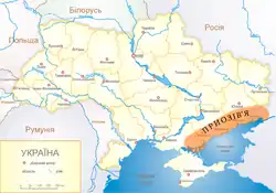
Legend: Приозів‘я - Pryazovia; Озівське море - Sea of Azov; Чорне море - Black Sea


Pryazovia (Ukrainian: Приазов'я, sometimes spelled Приозів‘я, Pryozivia; Russian: Приазовье, romanized: Priazovye) or literally Cis-Azov region is usually used to refer to the geographic area of the north coast of the Sea of Azov.[1] It is located in the southern part of the Azov-Kuban Lowland within the East European Plain, which surrounds the Sea of Azov for most of the stretch of coastline. In a more general sense it may mean the Azov Sea littoral, and conversely, to be more specific, it may also be referred to as the Northern Priazovye.
The (Northern) Priazovye consists of the southern parts of Donetsk Oblast and Zaporizhzhia Oblast and the eastern part of Kherson Oblast - all of Ukraine and the western part of Rostov Oblast of Russia. Following annexation and liquidation of Crimean Khanate, between 1783 and 1802 this land was part of Imperial Russian Novorossiya Governorate ("New Russia").
Ukraine's Greek minority population of 91,000 (in 2021) live mostly in the Pryazovia region, as a result of the Emigration of Christians from the Crimea in 1778.[2]
During the 2022 Russian invasion of Ukraine, the whole Pryazovia was occupied by Russian troops.
The southern edge of the Ukrainian Shield overlaps with Eastern Pryazovia.
References
- ↑ Hurska, Alla (12 February 2019). "Russia's Hybrid Strategy in the Sea of Azov: Divide and Antagonize (Part Two)". No. Volume: 16 Issue: 18. The Jamestown Foundation. Eurasia Daily Monitor.
- ↑ "Azov Sea Greeks Are Reviving Their Heritage in Ukraine", www.facebook.com/ukraineworld.org, retrieved 2021-08-18