Banan
ស្រុកបាណន់ | |
|---|---|
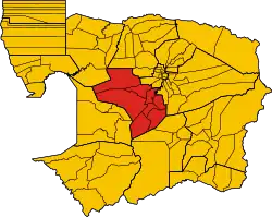
 Map of Banan District in red | |
| Country | |
| Province | Battambang |
| Communes | 8 |
| Villages | 72 |
| Population (1998)[1] | |
| • Total | 85,277 |
| Time zone | UTC+7 (ICT) |
| Geocode | 0201 |
Banan (Khmer: បាណន់ [ɓaːnɑn]) is a district (srok) in Battambang Province in north-western Cambodia.
Administration
The district is subdivided into 8 communes (khum) and 72 villages (phum).[2]
Communes and villages
| Khum (Communes) | Phum (Villages) |
|---|---|
| Kantueu Muoy | Thmei, Tuol Thnong, Svay Prey, Svay Bei Daeum, Kampong Ampil, Sasar Pok, Voat Kantueu |
| Kantueu Pir | Post Kantueu, Chamkar Ou, Banan, Kampang Lech, Kampang Kaeut, Chhay Rumpoat, Phnom Kul |
| Bay Damram | Tuol Chranieng, Kampong Chaeng, Kanhchroang, Krala Peas, Bay Damram, Ta Song, Sdau, Prey Totueng |
| Chheu Teal | Kampong Chamlang, Chheu Teal, Kampong Srama, Khnar, Enteak Chit, Bat Sala, Bay Damram, Svay Prakeab, Chhak Pou, Anlong Ta Mei, Chamkar Svay, Thkov, Praboh, Doung, Anlok Kaong |
| Chaeng Mean Chey | Rung, Chaeng, Kampong Kol Thmei, Thngor, Boh Khnor, Changhour Svay, Doang |
| Phnum Sampov | Chaeng Kdar, Kampov, Kouk Ampil, Sivuthea Kann, Sampov Kaeut, Samnanh, Kdaong, Krapeu Cheung, Krapeu Tboung, Krapeu Kaeut |
| Snoeng | Samraong, Kor, Snoeng Lech, Snoeng Kaeut, Boeng Chaeng, Boeng Prei, Peak Sbaek, Preah Srae, Rumchey, Sambuor Meas, Boeng Krasal |
| Ta Kream | Paoy Svay, Ta Kream, Thmei, Ou Pong Moan, Ta Ngaen, Prey Phdau, Ou Ta Nhea, Anlong Svay, Dangkut Thnong, Slab Pang, Andong Neang |
References
- ↑ General Population Census of Cambodia, 1998: Village Gazetteer. National Institute of Statistics. February 2000. pp. 16–17.
- ↑ "Battambang Administration". Royal Government of Cambodia. Archived from the original on 24 December 2008. Retrieved 2009-01-22.
This article is issued from Wikipedia. The text is licensed under Creative Commons - Attribution - Sharealike. Additional terms may apply for the media files.
