Bassetlaw District | |
|---|---|
| |
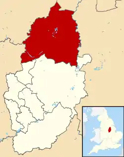 Shown within Nottinghamshire | |
| Sovereign state | United Kingdom |
| Constituent country | England |
| Region | East Midlands |
| Administrative county | Nottinghamshire |
| Founded | 1 April 1974 |
| Admin. HQ | Worksop |
| Government | |
| • Type | Non-metropolitan district |
| • Governing body | Bassetlaw District Council |
| • MPs: | Brendan Clarke-Smith, Robert Jenrick |
| Area | |
| • Total | 246.3 sq mi (637.8 km2) |
| • Rank | 55th |
| Population (2021) | |
| • Total | 118,351 |
| • Rank | Ranked 201st |
| • Density | 480/sq mi (190/km2) |
| Time zone | UTC+0 (Greenwich Mean Time) |
| • Summer (DST) | UTC+1 (British Summer Time) |
| Postcode Areas | |
| ONS code | 37UC (ONS) E07000171 (GSS) |
| Ethnicity | 96.4% White (92.0% White British) 1.2% Asian 1.2% Mixed 0.6% Black |


Bassetlaw is a local government district in north Nottinghamshire, England. Its council is based in the town of Worksop; the other towns in the district are Retford, Tuxford and Harworth Bircotes. The district also contains numerous villages and surrounding rural areas.
Bassetlaw is bounded to the south by the Newark and Sherwood and Mansfield districts, to the south-west by the Bolsover district of Derbyshire, to the north-west by the Metropolitan Borough of Rotherham and the City of Doncaster in South Yorkshire, to the north by North Lincolnshire, and to the east by West Lindsey.
The district is a non-constituent member of the South Yorkshire Mayoral Combined Authority.
History
The district was created on 1 April 1974 under the Local Government Act 1972, covering the whole of two former districts and most of another two, which were all abolished at the same time:[1]
- East Retford Municipal Borough
- East Retford Rural District (except parish of Finningley, which went to Doncaster)
- Worksop Municipal Borough
- Worksop Rural District (except part of parish of Harworth, which went to Doncaster and was added to the parish of Bawtry)
The new district was named Bassetlaw after the medieval Bassetlaw Wapentake, which had covered a similar area.[2][3] The council's logo now says "Bassetlaw District Council – North Nottinghamshire".
Governance
Bassetlaw District Council | |
|---|---|
| Type | |
| Type | |
| Leadership | |
David Armiger since August 2021[5] | |
| Structure | |
| Seats | 48 councillors |
Political groups |
|
| Elections | |
Last election | 4 May 2023 |
Next election | 6 May 2027 |
| Meeting place | |
 | |
| Queen's Buildings, Potter Street, Worksop, S80 2AH | |
| Website | |
| www | |
Bassetlaw District Council provides district-level services. County-level services are provided by Nottinghamshire County Council. Much of the district is also covered by civil parishes, which form a third tier of local government.[6][7]
Political control
The council has been under Labour majority control since 2011.
The first election to the council was held in 1973, initially operating as a shadow authority alongside the outgoing authorities before coming into its powers on 1 April 1974. Political control of the council since 1974 has been as follows:[8][9]
| Party in control | Years | |
|---|---|---|
| Labour | 1974–1976 | |
| No overall control | 1976–1979 | |
| Labour | 1979–2004 | |
| No overall control | 2004–2006 | |
| Conservative | 2006–2010 | |
| No overall control | 2010–2011 | |
| Labour | 2011–present | |
Leadership
The leaders of the council since 1991 have been:[10]
| Leader | Seat | Party | From | To | |
|---|---|---|---|---|---|
| Graham Oxby | Retford North | Labour | 1991 | May 2006 | |
| Mike Quigley | Retford East | Conservative | May 2006 | May 2011 | |
| Graham Oxby | Retford North | Labour | May 2011 | 16 May 2012 | |
| Simon Greaves | Worksop North East | Labour | 16 May 2012 | 22 Sep 2022 | |
| James Naish | Sturton | Labour | 22 Sep 2022 | ||
Composition
Following the 2023 election the composition of the council was:[11]
| Party | Councillors | |
|---|---|---|
| Labour | 38 | |
| Conservative | 8 | |
| Independent | 2 | |
| Total | 48 | |
The next election is due in 2027.
Elections
Since the last boundary changes in 2002 the council has comprised 48 councillors representing 25 wards, with each ward electing one, two or three councillors. Elections are held every four years.[12]
Most of the district is within the Bassetlaw constituency. The south-east of the district, including Tuxford, is in the Newark constituency.[7]
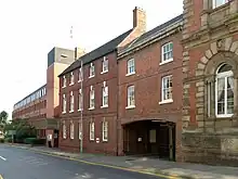
Premises
.jpg.webp)

Council meetings are held at both Worksop Town Hall, built in 1851,[13] and Retford Town Hall, built in 1868,[14] both of which the council inherited from its predecessor authorities. The council's main offices are at Queen's Buildings, completed in 1981 on Potter Street in Worksop, adjoining the Town Hall.[15] The council also maintains an area office in Harworth.[16]
Settlements


Bassetlaw is divided into 64 parishes, each governed by an elected parish council or parish meeting. The two main settlements of Retford and Worksop are the only areas of the district that are unparished, however, both towns are entitled to elect a town mayor via their respective charter trustees.
| Name | Status | Image | Population (2011)[17] | Ward(s) |
|---|---|---|---|---|
| Retford | Unparished (Charter trustees) | 22,023 |
| |
| Worksop | Unparished (Charter trustees) | 43,252 |
| |
| Askham | Civil parish |  St. Nicholas' Church, Askham | 181 | East Markham |
| Babworth | Civil parish |  Chesterfield Canal, Babworth | 1,687 | Sutton |
| Barnby Moor | Civil parish |  Ye Olde Bell, Barnby Moor | 278 | Sutton |
| Beckingham | Civil parish |  All Saints' Church, Beckingham | 1,098 | Beckingham |
| Bevercotes | Civil parish | _-_geograph.org.uk_-_724513.jpg.webp) Farm buildings in Bevercotes | Unknown | East Markham |
| Blyth | Civil parish |  St Mary and St Martin's Church, Blyth | 1,233 | Blyth |
| Bole | Civil parish |  St Martin's Church, Bole | 247 | Sturton |
| Bothamsall | Civil parish | .jpg.webp) Lound Hall, Bothamsall | 270 | East Markham |
| Carburton | Civil parish |  Ollerton Road Bridge, Carburton | Unknown | Welbeck |
| Carlton in Lindrick | Civil parish | .jpg.webp) St. John's Church, Carlton in Lindrick | 5,623 | Carlton |
| Clarborough and Welham | Civil parish |  Public house in Clarborough | 1,088 | Clayworth |
| Clayworth | Civil parish |  St Peter's Church, Clayworth | 419 | Clayworth |
| Clumber and Hardwick | Civil parish | Unknown | Welbeck | |
| Cottam | Civil parish |  Cottages in Cottam | 108 | Rampton |
| Darlton | Civil parish |  St. Giles Church, Darlton | 110 | Tuxford and Trent |
| Dunham-on-Trent | Civil parish |  St. Oswald's Church, Dunham-on-Trent | 343 | Tuxford and Trent |
| East Drayton | Civil parish |  St. Peter's Church, East Drayton | 252 | Tuxford and Trent |
| East Markham | Civil parish | .jpg.webp) St. John the Baptist Church | 1,160 | East Markham |
| Eaton | Civil parish |  Eaton | 233 | East Markham |
| Elkesley | Civil parish |  St. Giles Church, Elkesley | 822 | Welbeck |
| Everton | Civil parish |  Holy Trinity Church, Everton | 839 | Everton |
| Fledborough | Civil parish |  St Gregory's Church, Fledborough | Unknown | Tuxford and Trent |
| Gamston | Civil parish |  St Peter's Church, Gamston | 246 | East Markham |
| Gringley on the Hill | Civil parish |  St Peter & St Paul's Church | 699 | Everton |
| Grove | Civil parish |  View towards Grove | 105 | Rampton |
| Harworth Bircotes | Civil parish |  All Saints Church, Harworth | 7,948 | Harworth |
| Haughton | Civil parish |  Haughton watermill | Unknown | East Markham |
| Hayton | Civil parish |  St. Peter's Church, Hayton | 385 | Clayworth |
| Headon cum Upton | Civil parish |  St. Peter's Church, Headon | 253 | Rampton |
| Hodsock | Civil parish |  Hodsock Priory | 2,472 | Langold |
| Laneham | Civil parish |  Signpost in Laneham | 312 | Tuxford and Trent |
| Lound | Civil parish | 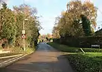 Lound | 471 | Sutton |
| Marnham | Civil parish |  St. Wilfrid's Church, Marnham | 117 | Tuxford and Trent |
| Mattersey | Civil parish |  All Saints' Church, Mattersey | 792 | Ranskill |
| Misson | Civil parish |  St. John the Baptist Church, Misson | 745 | Everton |
| Misterton | Civil parish |  All Saints' Church, Misterton | 2,140 | Misterton |
| Nether Langwith | Civil parish |  Public house in Nether Langwith | 526 | Welbeck |
| Normanton on Trent | Civil parish |  St. Matthew's Church | 345 | Tuxford and Trent |
| North and South Wheatley | Civil parish | .jpg.webp) Church of St. Peter and St. Paul's | 509 | Sturton |
| North Leverton with Habblesthorpe | Civil parish |  North Leverton Windmill | 1,047 | Sturton |
| Norton, Cuckney, Holbeck and Welbeck | Civil parish | 550 | Welbeck | |
| Ragnall | Civil parish |  St.Leonard's Church, Ragnall | Unknown | Tuxford and Trent |
| Rampton and Woodbeck | Civil parish |  All Saints' Church, Rampton | 1,139 | Rampton |
| Ranskill | Civil parish | .jpg.webp) Church of St Barnabas, Ranskill | 1,362 | Rampton |
| Rhodesia | Civil parish |  Chesterfield Canal, Rhodesia | 982 | Worksop North West |
| Saundby | Civil parish |  Church of St Martin of Tours | 165 | Worksop North West |
| Scaftworth | Civil parish |  Public house in Scaftworth | Unknown | Everton |
| Scrooby | Civil parish |  St. Wilfrid's Church, Scrooby | 315 | Blyth |
| Shireoaks | Civil parish | 1,432 | Worksop North West | |
| South Leverton | Civil parish |  All Saints’ Church, South Leverton | 480 | Rampton |
| Stokeham | Civil parish | .jpg.webp) St. Peter's Church, Stokeham | Unknown | Rampton |
| Sturton le Steeple | Civil parish |  Sturton le Steeple | 486 | Sturton |
| Styrrup with Oldcotes | Civil parish |  St. Helen's Church, Oldcotes | 684 | Blyth |
| Sutton | Civil parish |  St. Bartholomew's Church | 673 | Sutton |
| Torworth | Civil parish |  Great North Road, Torworth | 263 | Ranskill |
| Treswell | Civil parish | .jpg.webp) St. John the Baptist Church, Treswell | 211 | Rampton |
| Tuxford | Civil parish |  Tuxford High Street | 2,649 | Tuxford and Trent |
| Walkeringham | Civil parish |  St. Mary Magdalene Church, Walkeringham | 1,022 | Beckingham |
| Wallingwells | Civil parish | 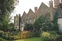 Wallingwells Hall | 22 | Carlton |
| West Burton | Civil parish | Unknown | Sturton | |
| West Drayton | Civil parish |  West Drayton | 225 | East Markham |
| West Markham | Civil parish |  All Saints' Church, West Markham | 170 | East Markham |
| West Stockwith | Civil parish |  West Stockwith lock | 327 | Misterton |
| Wiseton | Civil parish |  Cottages in Wiseton | Unknown | Clayworth |
_crossing_the_Chesterfield_Canal_-_geograph.org.uk_-_1041399.jpg.webp)


Wards
Bassetlaw is divided into 25 wards for electoral purposes. Each ward returns either one, two or three councillors at each election depending upon the number of electors within each ward.[18]
 |
Demography
Population
| Population of Bassetlaw (1811–2011) | |||||||
|---|---|---|---|---|---|---|---|
| Year | Population | Year | Population | Year | Population | ||
| 1811 | 25,813 | 1881 | 43,735 | 1951 | 101,590 | ||
| 1821 | 30,148 | 1891 | 45,203 | 1961 | 99,221 | ||
| 1831 | 32,950 | 1901 | 50,796 | 1971 | 96,918 | ||
| 1841 | 34,961 | 1911 | 57,084 | 1981 | 101,119 | ||
| 1851 | 37,180 | 1921 | 63,854 | 1991 | 105,354 | ||
| 1861 | 39,365 | 1931 | 71,427 | 2001 | 107,701 | ||
| 2011 | 112,863 | ||||||
| Pre-1974 statistics were gathered from local government areas that now comprise Bassetlaw. Source: Great Britain Historical GIS.[19] | |||||||
Religion
| Religion | Percent[20] |
|---|---|
| Christian | 81.53% |
| Buddhist | 0.09% |
| Hindu | 0.13% |
| Jewish | 0.05% |
| Muslim | 0.33% |
| Sikh | 0.07% |
| No religion | 9.99% |
Town twinning
 Farmers Branch, Texas, USA
 Garbsen, Germany
- Pfungstadt, Germany
 Aurillac, France
References
- ↑ "The English Non-metropolitan District (Definition) Order 1972", legislation.gov.uk, The National Archives, SI 1972/2039, retrieved 17 November 2023
- ↑ "The English Non-metropolitan Districts (Names) Order 1973", legislation.gov.uk, The National Archives, SI 1973/551, retrieved 31 May 2023
- ↑ "Bassetlaw | district, England, United Kingdom | Britannica". www.britannica.com. Retrieved 27 June 2023.
- ↑ "Council minutes, 17 May 2023". Bassetlaw District Council. Retrieved 20 December 2023.
- ↑ "Committee report, 28 April 2022" (PDF). Bassetlaw District Council. Retrieved 20 December 2023.
- ↑ "Local Government Act 1972", legislation.gov.uk, The National Archives, 1972 c. 70, retrieved 31 May 2023
- 1 2 "Election Maps". Ordnance Survey. Retrieved 21 September 2023.
- ↑ "Compositions calculator". The Elections Centre. Retrieved 10 August 2022.
- ↑ "Bassetlaw". BBC News Online. 19 April 2008. Retrieved 11 September 2009.
- ↑ "Council minutes". Bassetlaw District Council. Retrieved 20 August 2022.
- ↑ "Local elections 2023: live council results for England". The Guardian.
- ↑ "The District of Bassetlaw (Electoral Changes) Order 2000", legislation.gov.uk, The National Archives, SI 2000/3285, retrieved 20 December 2023
- ↑ Historic England. "Worksop Town Hall (1045762)". National Heritage List for England. Retrieved 2 April 2021.
- ↑ Historic England. "Town Hall (1370374)". National Heritage List for England. Retrieved 22 January 2021.
- ↑ "The Queen going on a walk about around Worksop 5 June 1981". Worksop Guardian. 25 February 2020. Retrieved 2 April 2021.
- ↑ "Contact and find us". Bassetlaw District Council. Retrieved 20 December 2023.
- ↑ "Local Area Reports". Nomis - Official Labour Market Statistics. Office for National Statistics. Retrieved 30 June 2020.
- ↑ "Bassetlaw". Local Government Boundary Commission for England. Retrieved 30 June 2020.
- ↑ Bassetlaw District: Historical statistics: Population, A Vision of Britain through Time, retrieved 18 April 2011
- ↑ Bassetlaw: Census Area Statistics, Office for National Statistics, retrieved 18 April 2011
