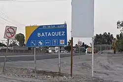
Batáquez
Estación Batáquez / Ejido Monterrey | |
|---|---|
Town | |
 | |
 Batáquez Location in Mexico | |
| Coordinates: 32°32′58″N 115°4′15″W / 32.54944°N 115.07083°W | |
| Country | |
| State | Baja California |
| Municipality | Mexicali |
| Elevation | 20 m (70 ft) |
| Population (2010) | |
| • Total | 1,121 |
| Time zone | UTC−8 (CST) |
'Batáquez' , 'Estación Batáquez' or 'Ejido Monterrey' , is a locality Mexican of the Valley of Mexicali, in the municipality from Mexicali, Baja California. According to data from INEGI, it is located at coordinates 32 ° 32'58 north latitude and 115 ° 04'15 west longitude and had 1,121 inhabitants in 2010. Despite being a small locality, Batáquez has local importance since it is head of the municipal delegation of the same name.
The name: Batáquez Station is derived from the fact that, from the beginning until the mid-twentieth century, there was a railway station in the town called: Intercalifornias railway or "pachuco train", which was called "Batáquez". Over time, the population center of Ejido Monterrey was located next to the aforementioned station.
Batáquez is communicated mainly by the federal highway No. 2, which crosses the town from east to west, and by the state highway No. 3, which intersects in this locality with the federal No 2 and heading south, this state highway is the road that connects with Guadalupe Victoria which is the most important town in the valley area of Mexicali.
History
In 1904 the company Southern Pacific was authorized to build a railway line south of the border to complete the stretch that would connect San Diego with Yuma. This branch entered national territory by Mexicali, then went east, to Los Algodones, and from there crossed the international line again, until Yuma. This railroad was known as Intercalifornia, but it was popularly called El Chinero, because most of its users through the valley were Chinese, who moved from one ranch to another to work agricultural and populated the rural areas in greater numbers than Mexicans.
Along the way, towns were emerging at the railway stations: Pascualitos, Sesbania, Cucapá, Pólvora, Hechicera, Batáquez, Paredones and Cuervos.
| Historical Demography | |
|---|---|
| Censos Years | Population |
| 1921 | 197 |
| 1930 | 377 |
| 1940 | 146 |
| 1950 | 340 |
| 1960 | 583 |
| 1970 | 625 |
| 1980 | 852 |
| 1990 | 983 |
| 1995 | 1,076 |
| 2000 | 1,258 |
| 2005 | 1,127 |
| 2010 | 1,121 |
References
External links
![]() Media related to Batáquez at Wikimedia Commons
Media related to Batáquez at Wikimedia Commons
