| Shire of Baw Baw Victoria | |||||||||||||||
|---|---|---|---|---|---|---|---|---|---|---|---|---|---|---|---|
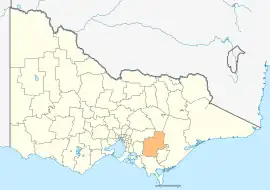 Location in Victoria | |||||||||||||||
| Population | 52,015 (2018)[1] | ||||||||||||||
| • Density | 12.9134/km2 (33.445/sq mi) | ||||||||||||||
| Established | 1994 | ||||||||||||||
| Gazetted | 2 December 1994[2] | ||||||||||||||
| Area | 4,028 km2 (1,555.2 sq mi)[1] | ||||||||||||||
| Mayor | Cr Michael Leaney | ||||||||||||||
| Council seat | Warragul | ||||||||||||||
| Region | Gippsland | ||||||||||||||
| State electorate(s) | Narracan | ||||||||||||||
| Federal division(s) | |||||||||||||||
| Website | Shire of Baw Baw | ||||||||||||||
| |||||||||||||||
The Shire of Baw Baw (/ˈbɔː ˈbɔː/) is a local government area in Victoria, Australia, in the eastern part of the state. It covers an area of 4,028 square kilometres (1,555 sq mi) and in June 2018 had a population of 52,015.[1]
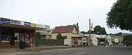
It includes the towns of Drouin, Longwarry, Neerim South, Trafalgar, Warragul and Yarragon. It was formed in 1994 from the amalgamation of the Shire of Buln Buln, Shire of Narracan, Rural City of Warragul, and some parts of the Shire of Upper Yarra.[2]
The shire is governed and administered by the Baw Baw Shire Council; its seat of local government and administrative centre is located at the council headquarters in Drouin, and it has a service centre located in Warragul. The shire is named after the major geographical feature in the region, the Baw Baw Plateau with Mount Baw Baw being the second highest peak in the region. An unincorporated area, the Mount Baw Baw Alpine Resort, is enclaved within the shire.
Location and geography
The more densely populated southern half of the shire consists of low rolling hills given over primarily to dairy farming and other agriculture. The northern half lies in the Great Dividing Range and its foothills, where forestry remains an important industry. Tourism is also important in the region, aided by its proximity to and easy access from Melbourne. The shire is known for its rural scenery and natural environment, as well as gourmet foods and wines. The historic gold-mining town of Walhalla is located in the northeast of the shire is a major tourist drawcard. The major electricity-producing region of the Latrobe Valley lies immediately to the shire's east and south.
Many of the shire's larger towns are located along the Princes Highway and main Gippsland Railway line, which cross the southern part of the shire. From west to east these include: Longwarry, Drouin, Warragul, Darnum, Yarragon, and Trafalgar. North of Warragul are Buln Buln, Neerim South, and Noojee, while south of Trafalgar in the Strzelecki Ranges lies the town of Thorpdale. The towns of Rawson, Erica, and Parkers Corner are located near Walhalla amongst the foothills of the Baw Baw Plateau. Aberfeldy is located in the far north east of the shire above the Thomson Dam, which supplies 50% of Melbourne's water.
Council
Composition up to November 2016
The council was composed of four wards and nine councillors, with three councillors elected to represent the Warragul Ward and two councillors per remaining ward elected to represent each of the other wards.[3]
| Ward | Party | Councillor | Notes | |
|---|---|---|---|---|
| Drouin | Independent | Tricia Jones | ||
| Independent | Terry Williamson | |||
| Mount Worth | Independent | Murray Cook | Mayor 2012/2013 and 2013/2014 | |
| Independent | Peter Kostos | |||
| North | Independent | David Balfour | ||
| Independent | Deborah Brown | Mayor 2014/2015 | ||
| Warragul | Independent | Joe Gauci | Mayor 2015/2016 | |
| Independent | Gerard Murphy | |||
| Independent | Mikaela Power | |||
Composition November 2016 to November 2020
The council was changed to a three-ward structure with three councillors per ward, with the new council sworn in on 2 November 2016. The new wards are West [660sq km] (primarily Drouin with some rural areas north/south), Central [66sq km] (Warragul town) and East [3,302sq km] making up the balance of the shire.
| Ward | Party | Councillor | Notes | |
|---|---|---|---|---|
| West | Independent | Tricia Jones | ||
| Independent | Keith Cook | |||
| Independent | Jessica O'Donnell | |||
| East | Independent | Michael Leaney | ||
| Independent | Peter Kostos | |||
| Independent | Darren Wallace | |||
| Central | Independent | Danny Goss | Mayor 2019/2020 | |
| Independent | Mikaela Power | Mayor 2018/19 | ||
| Independent | Joe Gauci | Mayor 2016/2017 and 2017/18 | ||
Current composition
The council's three-ward structure continued with three councillors per ward, with the new council sworn in on 18 November 2020. The wards are West [660sq km] (primarily Drouin with some rural areas north/south), Central [66sq km] (based on Warragul) and East [3,302sq km] making up the balance of the shire.
| Ward | Party | Councillor | Notes | |
|---|---|---|---|---|
| West | Independent | Tricia Jones | ||
| Independent | Ben Lucas | [resigned June 2021] replaced by Keith Cook | ||
| Independent | Annemarie McCabe | |||
| East | Independent | Michael Leaney | Mayor 2021/2022 | |
| Independent | Peter Kostos | |||
| Independent | Darren Wallace | |||
| Central | Independent | Danny Goss | Mayor 2020/2021 | |
| Independent | Jazmin Tauru | |||
| Independent | Joe Gauci | |||
Administration and governance
The council meets fortnightly in the Fountain Room of the West Gippsland Arts Centre. The council's administrative activities are centred in Drouin in the former offices of the Buln Buln Shire. It also provides customer services at both Warragul and the council offices in Drouin. Service centres in Trafalgar and on Smith Street in Warragul were closed in 2015.[4]
Townships and localities
The 2021 census, the shire had a population of 57,626 up from 48,479 in the 2016 census[5]
| Population | ||
|---|---|---|
| Locality | 2016 | 2021 |
| Aberfeldy | 0 | 7 |
| Ada | 0 | 0 |
| Allambee | 19 | 24 |
| Allambee Reserve^ | 95 | 96 |
| Allambee South | 76 | 61 |
| Amor | 0 | 4 |
| Athlone | 122 | 147 |
| Baw Baw | 0 | 0 |
| Bona Vista | 109 | 107 |
| Boola | 0 | 0 |
| Brandy Creek | 100 | 94 |
| Bravington | 17 | 14 |
| Buln Buln | 548 | 551 |
| Buln Buln East | 164 | 182 |
| Caringal | 19 | 16 |
| Childers | 106 | 91 |
| Cloverlea | 192 | 178 |
| Coalville | 49 | 55 |
| Coopers Creek | * | # |
| Crossover | 158 | 161 |
| Darnum | 751 | 759 |
| Delburn^ | 32 | 37 |
| Drouin | 12,349 | 15,287 |
| Drouin East | 182 | 177 |
| Drouin South | 335 | 343 |
| Drouin West | 330 | 361 |
| Ellinbank | 236 | 229 |
| Erica | 191 | 184 |
| Ferndale | 37 | 48 |
| Fumina | 11 | 11 |
| Fumina South | 67 | 65 |
| Gainsborough | 45 | 61 |
| Population | ||
|---|---|---|
| Locality | 2016 | 2021 |
| Gentle Annie | 0 | 0 |
| Hallora | 126 | 136 |
| Heath Hill^ | 161 | 189 |
| Hill End | 166 | 171 |
| Icy Creek | 11 | 28 |
| Jacob Creek | 23 | 28 |
| Jericho | 0 | 0 |
| Jindivick | 491 | 584 |
| Labertouche | 356 | 386 |
| Lardner | 117 | 110 |
| Lillico | 86 | 94 |
| Loch Valley | 0 | 0 |
| Longwarry^ | 2,004 | 2,436 |
| Longwarry North | 215 | 230 |
| Modella^ | 148 | 169 |
| Moe^ | 8,778 | 9,375 |
| Moe South^ | 541 | 529 |
| Moondarra | 46 | 49 |
| Mountain View | 90 | 85 |
| Narracan^ | 253 | 262 |
| Nayook | 75 | 70 |
| Neerim | 200 | 218 |
| Neerim East | 192 | 196 |
| Neerim Junction | 127 | 139 |
| Neerim North | 42 | 41 |
| Neerim South | 1,305 | 1,599 |
| Nilma | 342 | 410 |
| Nilma North | 319 | 344 |
| Noojee | 157 | 177 |
| Nyora^ | 1,527 | 1,644 |
| Piedmont | 46 | 52 |
| Poowong East^ | 82 | 88 |
| Population | ||
|---|---|---|
| Locality | 2016 | 2021 |
| Poowong North^ | 186 | 202 |
| Rawson | 296 | 296 |
| Ripplebrook | 221 | 268 |
| Rokeby | 180 | 213 |
| Seaview | 125 | 140 |
| Shady Creek | 180 | 186 |
| Strzelecki^ | 89 | 107 |
| Tanjil | 0 | 0 |
| Tanjil Bren | 14 | 7 |
| Tanjil South^ | 544 | 540 |
| Tetoora Road | 66 | 93 |
| Thalloo | * | # |
| Thomson | 0 | 0 |
| Thorpdale | 471 | 475 |
| Thorpdale South^ | 30 | 27 |
| Toombon | 0 | 0 |
| Toongabbie^ | 989 | 1,085 |
| Toorongo^ | 0 | 0 |
| Torwood | 50 | 49 |
| Trafalgar | 3,912 | 4,349 |
| Trafalgar East | 426 | 401 |
| Trafalgar South | 276 | 305 |
| Trida^ | 62 | 87 |
| Vesper | 42 | 50 |
| Walhalla^ | 20 | 35 |
| Warragul | 15,757 | 19,856 |
| Warragul South | 253 | 280 |
| Warragul West | 19 | 33 |
| Westbury | 157 | 163 |
| Willow Grove | 590 | 654 |
| Yallourn North^ | 1,545 | 1,511 |
| Yarragon | 1,650 | 1,893 |
| Yarragon South | 164 | 204 |
^ - Territory divided with another LGA
* - Not noted in 2016 Census
# - Not noted in 2021 Census
See also
References
- 1 2 3 "3218.0 – Regional Population Growth, Australia, 2017-18: Population Estimates by Local Government Area (ASGS 2018), 2017 to 2018". Australian Bureau of Statistics. Australian Bureau of Statistics. 27 March 2019. Retrieved 25 October 2019. Estimated resident population, 30 June 2018.
- 1 2 Victoria Government Gazette – Online Archive (1837–1997). "S94 of 1994: Order estg (Part 3) the Shire of Baw Baw". State Library of Victoria. State Government of Victoria (published 2 December 1994). p. 2. Retrieved 10 January 2014.
- ↑ Local Government in Victoria. "Baw Baw Shire Council". Department of Transport, Planning and Local Infrastructure. State Government of Victoria. Retrieved 10 January 2014.
- ↑ "Customer Service Centre Locations". Baw Baw Shire. Baw baw Shire. Retrieved 20 April 2016.
- ↑ "Census | Australian Bureau of Statistics". www.abs.gov.au. 11 January 2023.
External links
- Baw Baw Shire Council official website
- Visit Baw Baw official website
- Metlink local public transport map
- Link to Land Victoria interactive maps
Localities in the Shire of Baw Baw | ||
|---|---|---|
| City |  | |
| Town |
| |
| Locality |
| |
^ - Territory divided with another LGA | ||