Symons Valley Road | ||||
|---|---|---|---|---|
| Beddington Trail Highway 772 | ||||
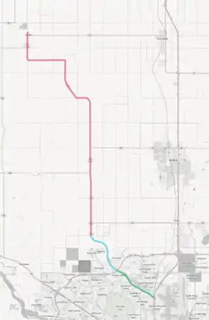 Beddington Trail (green), Calgary portion of Symons Valley Road (blue) and Rocky View County portion of Symons Valley Road (red) | ||||
| Route information | ||||
| Maintained by the City of Calgary and Alberta Transportation | ||||
| Beddington Trail | ||||
| Length | 6.1 km (3.8 mi) | |||
| South end | ||||
| North end | ||||
| Symons Valley Road | ||||
| Length | 39.3 km (24.4 mi) | |||
| South end | ||||
| North end | ||||
| Highway 772 | ||||
| Length | 31.1 km (19.3 mi) | |||
| South end | Calgary city limits | |||
| North end | ||||
| Location | ||||
| Country | Canada | |||
| Province | Alberta | |||
| Specialized and rural municipalities | Rocky View County | |||
| Major cities | Calgary | |||
| Highway system | ||||
|
| ||||
| ||||

Symons Valley Road is a major arterial road and rural highway that links Calgary from Stoney Trail (Highway 201) to Madden in Alberta, Canada. It is preceded by Beddington Trail, a major expressway along West Nose Creek linking Deerfoot Trail to Stoney Trail within Calgary, and is succeeded by Range Road 30. The portion of Symons Valley Road within Rocky View County from the Calgary city limit to Highway 574 south of Madden is designated as Alberta Provincial Highway No. 772.
Route description
Beddington Trail, which precedes Symons Valley Road, travels in a northwest direction from Deerfoot Trail forming the boundary between the communities of Beddington Heights and Sandstone Valley to the southwest and Aurora Business Park and Country Hills to the northeast. Prior to intersecting with Stoney Trail and continuing as Symons Valley Road, Beddington Trail bisects the community of Hidden Valley.
Within Calgary, Symons Valley Road from Stoney Trail to the city limit, just south of Township Road 261, forms the boundary between the communities of Kincora and Evanston before bisecting the community of Sage Hill. Upon leaving the City of Calgary, the roadway is designated as Highway 772 to its intersection with Highway 574, 1.8 km (1.1 mi) south of Madden.[1][2] After this intersection, Highway 772 becomes Highway 574 for 2.0 km (1.2 mi) to the north end of Madden, at which point Highway 574 turns east towards Crossfield.[1][3] In addition to being a numbered highway, Rocky View County has named the entirety of Highway 772, as well as the following 2.0 km (1.2 mi) of Highway 574, as Symons Valley Road.[4] Symons Valley Road is signed as Highway 772 from 144 Avenue, but does not officially start until just south of Township Road 261.[5]
Major intersections
| Rural/specialized municipality | Location | km[6] | mi | Destinations | Notes |
|---|---|---|---|---|---|
| City of Calgary | −12.5 | −7.8 | Y-Interchange; Hwy 2 exit 265; northbound exit, southbound entrance Beddington Trail southern terminus | ||
| −11.9 | −7.4 | Beddington Boulevard (to Centre Street) | |||
| −10.4 | −6.5 | Harvest Hills Boulevard | Trumpet interchange | ||
| −11.9 | −7.4 | Berkshire Boulevard (to Centre Street) / Country Hills Link | |||
| −8.6 | −5.3 | Country Hills Boulevard | Partial cloverleaf interchange | ||
| −7.1 | −4.4 | Hidden Creek Drive / Hidden Valley Link | |||
| −6.2 | −3.9 | Partial cloverleaf interchange; Hwy 201 exit 50 | |||
| Beddington Trail northern terminus • Symons Valley Road southern terminus | |||||
| −5.4 | −3.4 | Kincora Boulevard | |||
| −4.5 | −2.8 | Symons Valley Parkway | |||
| −2.7 | −1.7 | 114 Avenue NW | |||
| 0.0 | 0.0 | Calgary city limits | Hwy 772 southern terminus | ||
| Rocky View County | | 2.3 | 1.4 | ||
| 8.2 | 5.1 | South end of Hwy 567 concurrency | |||
| 11.4 | 7.1 | South end of Hwy 567 concurrency | |||
| 31.1 | 19.3 | South end of Hwy 574 concurrency | |||
| Madden | 33.1 | 20.6 | Range Road 30 | Hwy 772 / Symons Valley Road northern terminus | |
1.000 mi = 1.609 km; 1.000 km = 0.621 mi
| |||||
See also
References
- 1 2 "Provincial Highways 500 - 986 Progress Chart" (PDF). Alberta Transportation. March 2015. Retrieved May 17, 2016.
- ↑ Provincial Highway Designation: Highway 772 (Map). Alberta Transportation. January 1, 2010.
- ↑ Provincial Highway Designation: Highway 574 (Map). Alberta Transportation. January 1, 2010.
- ↑ "Rocky View County (map)" (PDF). Rocky View County. 2015. Retrieved November 7, 2016.
- ↑ "Symons Valley Rd north of 144 Ave NW". Google Street View. September 2014. Retrieved November 5, 2016.
- ↑