| Canal through Zuid-Beveland | |
|---|---|
 The route of the Canal through Zuid-Beveland | |
| Country | Netherlands |
| Specifications | |
| Length | 9 kilometres (5.6 miles; 4.9 nautical miles) |
| Lock length | 280 m (919 ft) [1] |
| Lock width | 24 m (79 ft) |
| Maximum boat length | 200 m (656 ft) [2] |
| Maximum boat beam | 23.5 m (77.1 ft) |
| Maximum boat draft | 4.8 m (15.7 ft) (depending on the tide) |
| Maximum boat air draft | 44 m (144 ft) (due to power lines) |
| Locks | 1 x 2 (originally 2 x 3) |
| Status | operational |
| History | |
| Construction began | 1850 |
| Date completed | 1866 |
| Geography | |
| Start point | Eastern Scheldt river, Netherlands |
| End point | Western Scheldt river, Netherlands |
| Beginning coordinates | 51°31′10″N 4°0′56″E / 51.51944°N 4.01556°E |
| Ending coordinates | 51°26′21″N 4°0′39″E / 51.43917°N 4.01083°E |


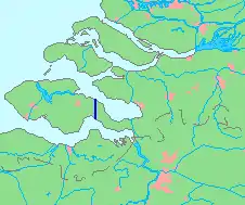
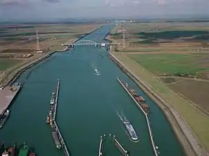
The Canal through Zuid-Beveland (Dutch: Kanaal door Zuid-Beveland) in the southwest Netherlands is the westernmost of two canals crossing the Zuid-Beveland peninsula. It connects the Western Scheldt near Hansweert (to the south of the canal) via a lock complex and the Eastern Scheldt (to the north) with which it has an open connection.
The canal is crossed by the Postbrug (which carries N670), a railroad bridge (which carries the Roosendaal–Vlissingen railway), and the Vlake Tunnel (which carries the A58 motorway). In addition, there are two small road bridges built on rollers (one over the southern end of the western lock chamber, and one over the northern end of the eastern lock chamber) which are used by pedestrians, cyclists and horseman.[3]
External links
References
- ↑ Ministry of Infrastructure and Water Management
- ↑ Dutch Ministry of Infrastructure and Water Management
- ↑ "Sluisdeur in buitenhoofd Hansweert". vaarweginformatie.nl. Rijkswaterstaat. Retrieved 7 July 2023.