53°26′17″N 1°29′31″W / 53.438°N 1.492°W
| West Ecclesfield | |
|---|---|
 Shown within Sheffield | |
| Area | 4.83 sq mi (12.5 km2) |
| Population | 17,699 |
| • Density | 3,664/sq mi (1,415/km2) |
| Metropolitan borough | |
| Metropolitan county | |
| Region | |
| Country | England |
| Sovereign state | United Kingdom |
| UK Parliament | |
| Councillors | John Booker (UKIP) Adam Hurst (Labour) Mike Levery (Liberal Democrats) |
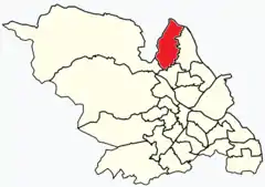
West Ecclesfield ward—which includes the districts of Burncross, Grenoside, High Green—is one of the 28 electoral wards in City of Sheffield, England. It is located in the northern part of the city and covers an area of 4.83 square miles (3,090 acres; 12.5 km2) in the western part of Ecclesfield Parish. The population of this ward in 2011 was 17,699 people in 7,675 households. West Ecclesfield was one of the six wards that made up the former Sheffield Hillsborough Parliamentary constituency. In their final report, the Boundary Commission for England recommended that West Ecclesfield form part of a reformed Penistone Parliamentary constituency. West Ecclesfield is composed of a number of polling districts. There are six in total; Angram Bank, Burncross, Grenoside one and two, Mortomley and Wortley Road.
Districts in West Ecclesfield ward
Burncross
Burncross (grid reference SK345961) is in the north of the ward west of Chapeltown. It is a mostly residential area, which includes the Grade II listed Barnes Hall, rebuilt in 1824.
Grenoside
Grenoside (grid reference SK340938) is isolated from the other two districts in the south of the ward. It is at a closer proximity to Parson Cross.
High Green
High Green (grid reference SK340972) is north-west of Burncross. It is the most northerly suburb of Sheffield.