Castor | |
|---|---|
Town | |
| Town of Castor | |
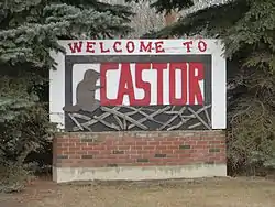
 Welcome sign in Castor | |
 Castor Location of Castor in Alberta | |
| Coordinates: 52°13′12″N 111°54′34″W / 52.22000°N 111.90944°W | |
| Country | Canada |
| Province | Alberta |
| Region | Central Alberta |
| Census division | 7 |
| Municipal district | County of Paintearth No. 18 |
| Incorporated[1] | |
| • Village | November 26, 1909 |
| • Town | June 27, 1910 |
| Government | |
| • Mayor | Richard Elhard |
| • Governing & body | Castor Town Council |
| • MP | Damien Kurek |
| • MLA | Nate Horner |
| Area (2021)[3] | |
| • Land | 2.61 km2 (1.01 sq mi) |
| Elevation | 816 m (2,677 ft) |
| Population (2021)[3] | |
| • Total | 803 |
| • Density | 307.9/km2 (797/sq mi) |
| Time zone | UTC−7 (MST) |
| • Summer (DST) | UTC−6 (MDT) |
| Postal code span | |
| Area code(s) | 403, 587 |
| Highways | Highway 12 Highway 36 |
| Waterways | Battle River Sullivan Lake |
| Website | Official website |
Castor is a town in Alberta, Canada. It is located at the intersection of Highway 12 and Highway 861, approximately 143 km (89 mi) east of the City of Red Deer. It has an elevation 816 m (2,677 ft).
Castor is French (also Latin) for beaver.[5] The town is known for its duck and geese migration in the fall since its territory includes many stopping points well frequented by migrating waterfowl.
History
.jpg.webp)
Castor was incorporated on July 13, 1910.
Demographics
In the 2021 Census of Population conducted by Statistics Canada, the Town of Castor had a population of 803 living in 383 of its 426 total private dwellings, a change of -13.6% from its 2016 population of 929. With a land area of 2.61 km2 (1.01 sq mi), it had a population density of 307.7/km2 (796.8/sq mi) in 2021.[3]
In the 2016 Census of Population conducted by Statistics Canada, the Town of Castor recorded a population of 929 living in 419 of its 448 total private dwellings, a -0.3% change from its 2011 population of 932. With a land area of 2.63 km2 (1.02 sq mi), it had a population density of 353.2/km2 (914.9/sq mi) in 2016.[6]
Tourism
Castor's tourism peaks during the summer months. Each year Castor's lake-like creek that wraps around the north-east end of the town, is a large drawing point for visitors. This one of a kind creek is framed by sandstone cliffs, and a visit will usually be filled with numerous wildlife sightings. The creek is one of the best places on the Alberta prairies for Kayaking and paddle-boarding. Other creek activities include motor-boating and swimming. On dry years natural beaches form at the base of some of the cliffs, giving visitors opportunities to dock their kayaks, during parts of creek. In addition to the creek, the town hosts many museums, including the towns original hospital dating back to 1911, the Machine Shed Museum, the Pharmacy Museum housed in the towns original drug store, the Beaver School Museum, the historic All Saints Anglican Church, the Grain Elevator Historical Site, and the Train Station Museum.
Economy
The town's main industries are agriculture, mining and oil and gas services.
Infrastructure
Castor is home to the Our Lady of the Rosary Hospital.[7]
Education
The Town of Castor has two schools, one Public named Gus Wetter School and one Catholic named Theresetta Catholic School. A source of humour for those familiar with Castor is the name of Gus Wetter's school men's sports teams: The Castor Raiders.
Media
The local newspaper is the Castor Advance covering news events occurring in Castor as well as neighbouring communities.
Literature
W. O. Mitchell was a teacher in Castor when he wrote Who Has Seen the Wind.
Notable people
- Darcy Tucker, former professional hockey player
See also
References
- ↑ "Location and History Profile: Town of Castor" (PDF). Alberta Municipal Affairs. October 7, 2016. p. 134. Retrieved October 16, 2016.
- ↑ Town of Castor. "Government Services". Archived from the original on 2007-09-27. Retrieved 2007-06-22.
- 1 2 3 "Population and dwelling counts: Canada, provinces and territories, and census subdivisions (municipalities)". Statistics Canada. February 9, 2022. Retrieved February 9, 2022.
- ↑ "Alberta Private Sewage Systems 2009 Standard of Practice Handbook: Appendix A.3 Alberta Design Data (A.3.A. Alberta Climate Design Data by Town)" (PDF) (PDF). Safety Codes Council. January 2012. pp. 212–215 (PDF pages 226–229). Archived from the original (PDF) on October 16, 2013. Retrieved October 8, 2013.
- ↑ Harper, Collins. "Castor_Beaver". Translation. Harper Collins. Retrieved 7 April 2017.
- ↑ "Population and dwelling counts, for Canada, provinces and territories, and census subdivisions (municipalities), 2016 and 2011 censuses – 100% data (Alberta)". Statistics Canada. February 8, 2017. Retrieved February 8, 2017.
- ↑ "Health Services". Town of Castor. Archived from the original on 2012-06-26. Retrieved 2012-10-13.