| Chari | |
|---|---|
 | |
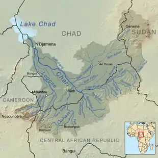
 Map showing the Chari River drainage basin. | |
| Location | |
| Countries | Central African Republic, Chad, Cameroon |
| Physical characteristics | |
| Source | Bamingui |
| • location | Mbolo, Central African Republic |
| • coordinates | 7°22′55″N 20°57′47″E / 7.382°N 20.963°E |
| • elevation | 549 m (1,801 ft) |
| 2nd source | Gribingui |
| • location | Mbrès, Central African Republic |
| • coordinates | 6°40′23″N 19°49′55″E / 6.673°N 19.832°E |
| • elevation | 631 m (2,070 ft) |
| Mouth | Lake Chad |
• location | Kinziyakeu, Cameroon |
• coordinates | 12°58′41″N 14°30′43″E / 12.978°N 14.512°E |
• elevation | 281 m (922 ft) |
| Length | 1,400 km (870 mi) |
| Basin size | 548,747 km2 (211,872 sq mi) |
| Discharge | |
| • location | N'djamena |
| • average | 1059 m3/s[1] |
| • minimum | 8 m3/s[1] |
| • maximum | 4846 m3/s[1] |
| Basin features | |
| Tributaries | |
| • left | Logone River |

The Chari River, or Shari River, is a 1,400 kilometres (870 mi) long river, flowing in Central Africa. It is Lake Chad's main source of water.[2]
Geography
The Chari River flows from the Central African Republic through Chad into Lake Chad, following the Cameroon border from N'Djamena, where it is joined by its western and principal tributary, the Logone River.
It provides 90 percent of the water flowing into Lake Chad. The watershed of the river covers 548,747 square kilometres (211,872 sq mi). The principal tributary is the Logone River, while minor tributaries include the Bahr Salamat, the Bahr Sah), the Bahr Aouk and the Bahr Kéita.
Much of Chad's population, including Sarh and the capital N'Djamena, is concentrated around it.
As of 2016, Chad remains one of four countries where Guinea worm disease remains endemic. The majority of remaining cases are concentrated around the Chari River.
The river supports an important local fishing industry. One of the most highly prized local fish is the Nile perch.
Since the 1960s, there have been proposals to divert water from the Ubangi River to the Chari to revitalize Lake Chad, which would constitute a reversal of the capture of the upper Ubangi from the Chari by the Congo that is believed to have occurred in the early Pleistocene.[3]
History
The Sao people are said to have lived by this river.[4]
The Chari River basin has been populated by diverse speakers of the Chadic languages, Adamawa languages, Ubangian languages, Bongo-Bagirmi languages.
See also
- Oubangui-Chari
- Chari–Baguirmi Region
- Moyen-Chari Region
- Chari–Nile languages
- Chari River topics
- Lake Chad topics
- Lake Chad replenishment project
- Waterway
References
- 1 2 3 "GRDC station information for Njamena (Fort Lamy)".
- ↑ "Chari River | river, Africa". Encyclopedia Britannica. Retrieved 2017-06-06.
- ↑ See Cooper, John E. and Hull, Gordon; Gorilla Pathology and Health: With a Catalogue of Preserved Materials, p. 371 ISBN 9780128020395
- ↑ Li, Ying; Trillo, E. A.; Murr, L. E. (2000). "Friction-stir welding of aluminum alloy 2024 to silver". Journal of Materials Science Letters. 19 (12): 1047–1051. doi:10.1023/a:1006795221194. ISSN 0261-8028. S2CID 135070501.