College Bayside | ||||||||||||||||||||
|---|---|---|---|---|---|---|---|---|---|---|---|---|---|---|---|---|---|---|---|---|
| Metromover people mover station | ||||||||||||||||||||
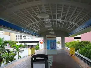
 Interior of the College Bayside Metromover station | ||||||||||||||||||||
| General information | ||||||||||||||||||||
| Location | 225 NE Third Street Miami, Florida 33132 | |||||||||||||||||||
| Coordinates | 25°46′39″N 80°11′23″W / 25.77750°N 80.18972°W | |||||||||||||||||||
| Owned by | Miami-Dade County | |||||||||||||||||||
| Platforms | 1 island platform | |||||||||||||||||||
| Tracks | 2 | |||||||||||||||||||
| Connections | ||||||||||||||||||||
| Construction | ||||||||||||||||||||
| Accessible | Yes | |||||||||||||||||||
| History | ||||||||||||||||||||
| Opened | April 17, 1986 | |||||||||||||||||||
| Services | ||||||||||||||||||||
| ||||||||||||||||||||
College Bayside is a Metromover station in Downtown, Miami, Florida, adjacent to the Wolfson Campus of Miami Dade College and one block west of the Bayside Marketplace.
This station is located at Northeast Third Street and Second Avenue. It opened to service April 17, 1986 and is the last station to transfer directly to the Omni Loop.
Station layout
| P Platform level |
Inner loop | ← Inner Loop toward Government Center (First Street) |
| Island platform, doors will open on the left | ||
| Outer loop | Brickell Loop toward Financial District (College North) → Omni Loop toward School Board (College North) → | |
| G | Street level | Exit/entrance and buses |
Places of interest
- Miami Dade College (Wolfson Campus)
- Bayside Marketplace
- Hard Rock Cafe
- Tropicalsailing
- Hooters
- Off the Hookah
- Middle East Grill
- Fat Tuesday
- Lombardi's Restaurante
- Bubba Gump Shrimp Co.
- Los Ranchos of Bayside
- Island Queen Cruises
- Bayside Plaza Office Building
- Vizcayne
- New World School of the Arts
- School for Advanced Studies
- The Loft 2
- Loft Miami
- Loft 3
- 200 Third Street Building
- Holiday Inn Port of Miami-Downtown Hotel
External links
 Media related to College/Bayside metro station at Wikimedia Commons
- MDT – Metromover Stations
- 3rd Street entrance from Google Maps Street View
- 4th Street entrance from Google Maps Street View
This article is issued from Wikipedia. The text is licensed under Creative Commons - Attribution - Sharealike. Additional terms may apply for the media files.