| Dharampur State | |||||||
|---|---|---|---|---|---|---|---|
| Princely State of British India | |||||||
| 1262–1948 | |||||||
 Flag
 Coat of arms
| |||||||
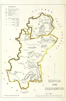
 Bansda and Dharampur, 1896 | |||||||
| Capital | Dharampur | ||||||
| Area | |||||||
• 1892 | 1,823 km2 (704 sq mi) | ||||||
| Population | |||||||
• 1892 | 102,000 | ||||||
| History | |||||||
• Established | 1262 | ||||||
| 1948 | |||||||
| |||||||
| Rajput Provinces of India - Dharampur (Princely State) | |||||||
Dharampur State was a princely state in India during the time of the British Raj. Its last ruler acceded to the Union of India 10 June 1948.[1]
Geography

Dharampur (blue) within Surat Agency
Dharampur State had an area of 1,823 km2 and fell under the Surat Agency of the Bombay Presidency.[1][2]
History
Dharampur State was founded in 1262. Its capital was moved to Mandvegan in 1766 and was renamed Dharampur. On 31 Dec 1802 Dharampur became a British protectorate. The state was ruled by Sisodhyia dynasty. The rulers had the title Rana Maharana Sahib and were accorded a status of 9-gun salute by the British authorities.

Standard Herald that had belonged to a descendant of the royal family of Dharampur State.
Rulers
- Oct 1680 - 1727 Sahadevji (d. 1727)
- 1727 - 1758 Ramdevji II (d. 1758)
- 1758 - 1774 Dharamdevji (d. 1774)
- 1774 - 1777 Narandevji I (Guman Singh) (d. 1777)
- 1774 - 1777 Maharani Baiji Kushal (d. 1784) Kunverba (f) (1st time) -Regent
- 1777 - 1784 Somdevji II (Abhay Singh) (d. 1784)
- 1777 - 1784 Maharani Baiji Kushal (s.a.) Kunverba (f) (2nd time) -Regent
- 1784 - 1807 Rupdevji (b. 1783 - d. 1807)
- 1784 - 1800 Maharani Baiji Kushal Kunverba (d. af.1808) Sahib (f) -Regent
- 1807 - 1857 Vijaidevji I (d. 1857)
- 1857 - 20 Jan 1860 Ramdevji III Vijayadevji (d. 1860)
- 20 Jan 1860 – 17 Sep 1891 Narayandevji Ramdevji (b. ... - d. 1891)
- 1891 - 26 Mar 1921 Mohandevji Narayandevji (b. 1863 - d. 1921)
- 26 Mar 1921 – 15 Aug 1947 Vijaidevji Mohandevji (b. 1884 - d. 1952)
- 1952 - Sahadevji Vijaidevji
- Present - Vacant
References
- 1 2 "Dharampur". Archived from the original on 21 February 2011. Retrieved 22 August 2011.
- ↑ "GJ tourism". Archived from the original on 28 September 2011. Retrieved 22 August 2011.
- ↑ "Indian states before 1947 A-J". rulers.org. Retrieved 13 August 2019.
External links
This article is issued from Wikipedia. The text is licensed under Creative Commons - Attribution - Sharealike. Additional terms may apply for the media files.