Ermera | |
|---|---|
| |
 Ermera | |
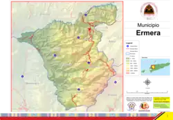
 Official map | |
 | |
OpenStreetMap | |
| Coordinates: 8°50′S 125°23′E / 8.833°S 125.383°E | |
| Country | |
| Capital | Gleno |
| Administrative posts | |
| Area | |
| • Total | 756.5 km2 (292.1 sq mi) |
| • Rank | 10th |
| Population (2015 census) | |
| • Total | 125,702 |
| • Rank | 2nd |
| • Density | 170/km2 (430/sq mi) |
| • Rank | 2nd |
| Households (2015 census) | |
| • Total | 20,671 |
| • Rank | 3rd |
| Time zone | UTC+09:00 (TLT) |
| ISO 3166 code | TL-ER |
| HDI (2017) | 0.562[1] medium · 11th |
| Website | Ermera Municipality |
Ermera (Portuguese: Município Ermera, Tetum: Munisípiu Ermera) is one of the municipalities (formerly districts) of East Timor, located in the west-central part of the country. It has a population of 117,064 (Census 2010) and an area of 756.5 km².
Etymology
The word Ermera means 'red water' in the local Mambai language.[2] It is said that the ancestors of today's inhabitants of the municipality originated from three mountains, namely Cailitlau, Lalimlau, and Hituria, and that the name Ermera refers to the red waters flowing from those mountains.[3]
Geography

Ermera is one of only two land-locked municipalities in East Timor, the other being Aileu. It borders Liquiçá to the north, Dili to the northeast, Alieu to the east, Ainaro to the southeast, and Bobonaro to the west.
The boundaries of the municipality are identical to those of the district of the same name in Portuguese Timor. Its capital is Gleno, which is located 30 km to the southwest of the national capital, Dili. The city of Ermera, also known as Vila Ermera, lies 58 km from the capital along the same road. In Marobo (Atsabe Administrative Post) are the remains of a hot springs bath from colonial times. The pool is still in use.[4]
 Subdivisions of Ermera |
 Cities of Ermera |
Administrative posts
The municipality's administrative posts (formerly sub-districts) are:[5][6]
- Atsabe Administrative Post
- Ermera Administrative Post
- Hatulia Administrative Post
- Hatulia B Administrative Post
- Letefoho Administrative Post
- Railaco Administrative Post
The administrative posts are divided into 52 sucos ("villages") in total.
References
Notes
- ↑ "Sub-national HDI - Area Database - Global Data Lab". hdi.globaldatalab.org. Retrieved 13 September 2018.
- ↑ Hull, Geoffrey (June 2006). "The placenames of East Timor" (PDF). Placenames Australia: Newsletter of the Australian National Placenames Survey: 6–7. Archived from the original (PDF) on 14 February 2017. Retrieved 5 June 2018.
- ↑ "Perfil: 2. Toponímia" [Profile: 2. Toponymy]. Ermera Municipality (in Tetum). Retrieved 18 July 2022.
- ↑ Jane's Oceania: Timor - Facts about Timor
- ↑ Gunn, Geoffrey C (2011). Historical Dictionary of East Timor. Lanham, Maryland: Scarecrow Press. p. 84. ISBN 9780810867543.
- ↑ Soares Martins, Evaristo (31 May 2022). "Parlamento Nacional aprova propostade lei da divisão administrativa do territorio na final global" [National Parliament globally finally approves proposal for a law on the administrative division of the territory] (in Portuguese). Tatoli. Archived from the original on 14 August 2021. Retrieved 28 August 2022.
Bibliography
- Ermera District Profile (PDF) (Report). April 2002. Archived from the original (PDF) on 28 March 2009. Retrieved 27 February 2022.
- Munisipio Ermera: Planu Estartejiku Desenvolvimentu Munisipal [Ermera Municipality: Municipal Strategic Development Plan] (Report) (in Tetum). Ministry of State Administration (East Timor) / Administration of Ermera Municipality. 2015. Retrieved 18 July 2022.
- Perfil Distritu Ermera [Ermera District Profile] (PDF) (Report) (in Tetum). 2012. Archived (PDF) from the original on 16 March 2016. Retrieved 18 July 2022.
External links
![]() Media related to Ermera (Municipality) at Wikimedia Commons
Media related to Ermera (Municipality) at Wikimedia Commons
- Ermera Municipality – official site (in Tetum with some content in English)
- Ermera Municipality – information page on Ministry of State Administration site (in Portuguese and Tetum)