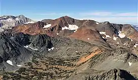
| Excelsior Mountain | |
|---|---|
 Northeast aspect, from Dunderberg Peak | |
| Highest point | |
| Elevation | 12,446 ft (3,794 m) NAVD 88[1] |
| Prominence | 1,246 ft (380 m)[1] |
| Parent peak | Dunderberg Peak |
| Coordinates | 38°1′28″N 119°18′19″W / 38.02444°N 119.30528°W[1] |
| Geography | |
 Excelsior Mountain Location of Excelsior Mountain in California  Excelsior Mountain Excelsior Mountain (the United States) | |
| Location | Yosemite National Park, Mono County, Tuolumne County, California, U.S. |
| Parent range | Ritter Range, Sierra Nevada |
| Topo map | USGS Tenaya Lake |
| Climbing | |
| Easiest route | From Virginia Lakes Trailhead, class 2[2] |
Excelsior Mountain is the 21st-highest mountain in Yosemite National Park, on the northeastern border of Yosemite. It is the next high peak, north of Mount Conness. Excelsior Mountain is mostly made of rust-colored metamorphic rock, similar to Mount Dana, which is also close.[2]
Climate
| Climate data for Excelsior Mountain (Yosemite) 38.0242 N, 119.3074 W, Elevation: 12,014 ft (3,662 m) (1991–2020 normals) | |||||||||||||
|---|---|---|---|---|---|---|---|---|---|---|---|---|---|
| Month | Jan | Feb | Mar | Apr | May | Jun | Jul | Aug | Sep | Oct | Nov | Dec | Year |
| Mean daily maximum °F (°C) | 29.8 (−1.2) |
28.8 (−1.8) |
31.6 (−0.2) |
35.1 (1.7) |
42.6 (5.9) |
52.2 (11.2) |
59.9 (15.5) |
59.3 (15.2) |
53.7 (12.1) |
44.8 (7.1) |
36.1 (2.3) |
29.8 (−1.2) |
42.0 (5.6) |
| Daily mean °F (°C) | 20.0 (−6.7) |
18.2 (−7.7) |
20.6 (−6.3) |
23.6 (−4.7) |
30.7 (−0.7) |
40.0 (4.4) |
47.3 (8.5) |
46.6 (8.1) |
41.2 (5.1) |
33.3 (0.7) |
25.8 (−3.4) |
20.0 (−6.7) |
30.6 (−0.8) |
| Mean daily minimum °F (°C) | 10.1 (−12.2) |
7.7 (−13.5) |
9.6 (−12.4) |
12.1 (−11.1) |
18.8 (−7.3) |
27.8 (−2.3) |
34.8 (1.6) |
34.0 (1.1) |
28.6 (−1.9) |
21.8 (−5.7) |
15.6 (−9.1) |
10.3 (−12.1) |
19.3 (−7.1) |
| Average precipitation inches (mm) | 9.30 (236) |
7.91 (201) |
7.26 (184) |
3.77 (96) |
2.33 (59) |
0.67 (17) |
0.64 (16) |
0.49 (12) |
0.63 (16) |
2.48 (63) |
3.79 (96) |
7.86 (200) |
47.13 (1,196) |
| Source: PRISM Climate Group[3] | |||||||||||||
Near to Excelsior Mountain
All of the following are near to Excelsior Mountain:[4]
| Mountain | Distance |
|---|---|
| Shepherd Crest | 2.3 miles (3.7 km) |
| Black Mountain | 2.8 miles (4.5 km) |
| Epidote Peak | 3.9 miles (6.3 km) |
| Camiaca Peak | 4.3 miles (6.9 km) |
| Mount Scowden | 4.4 miles (7.1 km) |
| Page Peaks | 4.7 miles (7.6 km) |
| North Peak | 4.8 miles (7.7 km) |
| Grey Butte | 4.8 miles (7.7 km) |
| Dunderberg Peak | 5.2 miles (8.4 km) |
| Mount Olsen | 5.5 miles (8.9 km) |
| Gabbro Peak | 5.6 miles (9.0 km) |
| Sheep Peak | 5.6 miles (9.0 km) |
| Stanton Peak | 6.3 miles (10.1 km) |
| Mount Conness | 6.5 miles (10.5 km) |
| Virginia Peak | 6.5 miles (10.5 km) |
| Gilcrest Peak | 6.7 miles (10.8 km) |
| Twin Peaks | 7.9 miles (12.7 km) |
| Mount Warren | 8.0 miles (12.9 km) |
| White Mountain | 8.7 miles (14.0 km) |
| Whorl Mountain | 8.8 miles (14.2 km) |
| False False White Peak | 9.4 miles (15.1 km) |
| False White Peak | 9.8 miles (15.8 km) |
| Tioga Peak | 9.8 miles (15.8 km) |
See also
References
- 1 2 3 "Excelsior Mountain, California". Peakbagger.com. Retrieved 2009-03-25.
- 1 2 "Excelsior Mountain". SummitPost.org. Retrieved 2019-02-25.
- ↑ "PRISM Climate Group, Oregon State University". PRISM Climate Group, Oregon State University. Retrieved October 8, 2023.
To find the table data on the PRISM website, start by clicking Coordinates (under Location); copy Latitude and Longitude figures from top of table; click Zoom to location; click Precipitation, Minimum temp, Mean temp, Maximum temp; click 30-year normals, 1991-2020; click 800m; click Retrieve Time Series button.
- ↑ "Excelsior Mountain at peakery.com".
External links and references
This article is issued from Wikipedia. The text is licensed under Creative Commons - Attribution - Sharealike. Additional terms may apply for the media files.