Fūren
風連町 | |
|---|---|
.svg.png.webp) Flag .svg.png.webp) Emblem | |
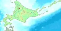
 Location of Fūren in Hokkaido (Kamikawa Subprefecture) | |
 Fūren Location in Japan | |
| Coordinates: 44°17′32″N 142°24′51″E / 44.29222°N 142.41417°E | |
| Country | Japan |
| Region | Hokkaido |
| Prefecture | Hokkaido (Kamikawa Subprefecture) |
| Now part of Nayoro | 27 March 2006 |
| Area | |
| • Total | 220.61 km2 (85.18 sq mi) |
| Population (2005) | |
| • Total | 5,234 |
| • Density | 23.73/km2 (61.5/sq mi) |
| Time zone | UTC+09:00 (JST) |
| City hall address | 1 of 196 West, Fūren-cho, Kamikawa-gun, Hokkaido 095-0507 |
| Symbols | |
| Flower | Phlox subulata |
| Tree | Betula platyphylla |
Fūren (風連町, Fūren-chō) was a town located in Kamikawa (Teshio) District, Kamikawa Subprefecture, Hokkaido, Japan.
As of 2004, the town had an estimated population of 5,234 and a density of 23.73 persons per km2. The total area was 220.61 km2.
On 27 March 2006, Fūren was merged into the expanded city of Nayoro. Before its dissolution, the town mascot was "Fumi-kun".
The primary industry in Fūren-chō is wet-rice farming.
External links
- Nayoro official website (in Japanese)
This article is issued from Wikipedia. The text is licensed under Creative Commons - Attribution - Sharealike. Additional terms may apply for the media files.