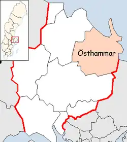
Östhammar Municipality
Östhammars kommun | |
|---|---|
 | |
 Coat of arms | |
 | |
| Coordinates: 60°16′N 18°22′E / 60.267°N 18.367°E | |
| Country | Sweden |
| County | Uppsala County |
| Seat | Östhammar |
| Government | |
| • Mayor | Fabian Sjöberg (Moderate Party) |
| Area | |
| • Total | 3,486.4 km2 (1,346.1 sq mi) |
| • Land | 1,475.28 km2 (569.61 sq mi) |
| • Water | 2,011.12 km2 (776.50 sq mi) |
| Area as of 1 January 2014. | |
| Population (31 December 2021)[2] | |
| • Total | 22,364 |
| • Density | 6.4/km2 (17/sq mi) |
| Time zone | UTC+1 (CET) |
| • Summer (DST) | UTC+2 (CEST) |
| ISO 3166 code | SE |
| Province | Uppland |
| Municipal code | 0382 |
| Website | www.osthammar.se |
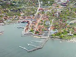
Östhammar Municipality (Östhammars kommun) is a municipality in Uppsala County in east central Sweden. Its seat is located in the city of Östhammar.
The present municipality was created during the local government reform in the late sixties and early seventies. Already in 1967 the City of Öregrund joined the City of Östhammar in a common municipality. It was the first time a former city joined another local government unit. By 1971 the new combined city became a municipality of unitary type and in 1974 more units were added.
In June 2018 the municipal council voted in favour of the building of Forsmark nuclear waste repository, with the final decision needing to be made by the Swedish government.[3]
Localities
All towns with over 200 inhabitants in 2000, from Statistics Sweden.
- Östhammar (seat)
- Gimo
- Österbybruk
- Hargshamn
- Dannemora
- Öregrund
- Alunda
- Skoby (part of this bimunicipal locality is in Uppsala Municipality)
- Norrskedika
Another notable village is Forsmark (pop. 59), where the Forsmark Nuclear Power Plant is situated.
Demographics
This is a demographic table based on Östhammar Municipality's electoral districts in the 2022 Swedish general election sourced from SVT's election platform, in turn taken from SCB official statistics.[4]
Residents include everyone registered as living in the district, regardless of age or citizenship status. Valid voters indicate Swedish citizens above the age of 18 who therefore can vote in general elections. Left vote and right vote indicate the result between the two major blocs in said district in the 2022 general election. Employment indicates the share of people between the ages of 20 and 64 who are working taxpayers. Foreign background is defined as residents either born abroad or with two parents born outside of Sweden. Median income is the received monthly income through either employment, capital gains or social grants for the median adult above 20, also including pensioners in Swedish kronor. The section about college graduates indicates any degree accumulated after high school.
In total there were 17,497 Swedish citizens of voting age resident in the municipality.[4] 42.1 % voted for the left coalition and 56.9 % for the right coalition.
| Location | Residents | Valid voters | Left vote | Right vote | Employed | SV parents | 1st/2nd gen | Income | College |
|---|---|---|---|---|---|---|---|---|---|
| % | % | % | % | % | % | ||||
| Alunda-Ekeby | 2,138 | 1,651 | 35.8 | 63.0 | 88 | 94 | 6 | 26,935 | 29 |
| Alunda tätort | 2,544 | 1,829 | 39.0 | 59.9 | 88 | 92 | 8 | 26,275 | 32 |
| Ed | 1,588 | 1,211 | 42.4 | 57.0 | 90 | 89 | 11 | 27,948 | 30 |
| Gimo-Hökhuvud-Vattensta | 1,611 | 1,240 | 44.8 | 54.3 | 88 | 86 | 14 | 27,335 | 23 |
| Gimo V | 1,812 | 1,306 | 45.1 | 54.0 | 76 | 71 | 29 | 23,488 | 22 |
| Hargshamn-Boda | 1,387 | 1,131 | 45.5 | 53.4 | 86 | 89 | 11 | 25,644 | 29 |
| Kristinelund-Boda | 1,534 | 1,101 | 46.5 | 52.5 | 78 | 80 | 20 | 23,682 | 32 |
| Norrskedika-Valö-Forsmark | 1,332 | 1,131 | 40.5 | 58.6 | 85 | 92 | 8 | 25,930 | 23 |
| Öregrund N-Gräsö | 1,408 | 1,261 | 42.9 | 56.6 | 84 | 94 | 6 | 23,926 | 30 |
| Öregrund S-Söderön | 1,785 | 1,450 | 39.7 | 59.9 | 87 | 92 | 8 | 26,182 | 30 |
| Österbybruk-Dannemora | 2,076 | 1,584 | 42.5 | 56.1 | 86 | 85 | 15 | 24,980 | 21 |
| Österbybruk-Morkarla | 1,667 | 1,315 | 40.0 | 57.8 | 85 | 87 | 13 | 25,694 | 20 |
| Östhammars C | 1,470 | 1,287 | 47.1 | 52.3 | 85 | 90 | 10 | 23,710 | 29 |
| Source: SVT[4] | |||||||||
Climate
Österbybruk has a humid continental climate that is quite mild throughout the year, especially considering its northerly latitude.
| Climate data for Österbybruk, 2002-2015 (precipitation 1961-1990) | |||||||||||||
|---|---|---|---|---|---|---|---|---|---|---|---|---|---|
| Month | Jan | Feb | Mar | Apr | May | Jun | Jul | Aug | Sep | Oct | Nov | Dec | Year |
| Record high °C (°F) | 10.0 (50.0) |
11.9 (53.4) |
17.7 (63.9) |
27.4 (81.3) |
28.6 (83.5) |
30.6 (87.1) |
34.4 (93.9) |
32.8 (91.0) |
27.6 (81.7) |
20.6 (69.1) |
14.4 (57.9) |
12.6 (54.7) |
34.4 (93.9) |
| Mean daily maximum °C (°F) | −0.5 (31.1) |
0.2 (32.4) |
4.4 (39.9) |
10.9 (51.6) |
15.9 (60.6) |
19.7 (67.5) |
23.0 (73.4) |
21.6 (70.9) |
16.6 (61.9) |
9.4 (48.9) |
4.4 (39.9) |
1.1 (34.0) |
10.5 (50.9) |
| Daily mean °C (°F) | −3.5 (25.7) |
−3.1 (26.4) |
−0.1 (31.8) |
5.3 (41.5) |
10.0 (50.0) |
14.4 (57.9) |
17.3 (63.1) |
16.0 (60.8) |
11.5 (52.7) |
5.7 (42.3) |
1.9 (35.4) |
−1.7 (28.9) |
6.1 (43.0) |
| Mean daily minimum °C (°F) | −6.6 (20.1) |
−6.5 (20.3) |
−4.6 (23.7) |
−0.2 (31.6) |
4.2 (39.6) |
8.1 (46.6) |
11.6 (52.9) |
10.5 (50.9) |
6.4 (43.5) |
2.0 (35.6) |
−0.6 (30.9) |
−4.4 (24.1) |
1.6 (34.9) |
| Record low °C (°F) | −34.0 (−29.2) |
−30.4 (−22.7) |
−27.3 (−17.1) |
−13.8 (7.2) |
−5.6 (21.9) |
−2.0 (28.4) |
1.0 (33.8) |
−1.0 (30.2) |
−4.7 (23.5) |
−15.6 (3.9) |
−20.9 (−5.6) |
−32.4 (−26.3) |
−34.0 (−29.2) |
| Average precipitation mm (inches) | 46.5 (1.83) |
32.5 (1.28) |
33.2 (1.31) |
35.0 (1.38) |
31.7 (1.25) |
38.8 (1.53) |
74.6 (2.94) |
73.8 (2.91) |
58.9 (2.32) |
55.1 (2.17) |
62.0 (2.44) |
51.6 (2.03) |
593.6 (23.37) |
| Source 1: SMHI[5] | |||||||||||||
| Source 2: SMHI Monthly Data 2002-2015[6] | |||||||||||||
| Climate data for Films Kyrkby, 1961-2018 (precipitation 1961-1990) | |||||||||||||
|---|---|---|---|---|---|---|---|---|---|---|---|---|---|
| Month | Jan | Feb | Mar | Apr | May | Jun | Jul | Aug | Sep | Oct | Nov | Dec | Year |
| Mean daily maximum °C (°F) | −1.3 (29.7) |
−1.2 (29.8) |
2.6 (36.7) |
9.0 (48.2) |
15.4 (59.7) |
20.0 (68.0) |
21.7 (71.1) |
19.9 (67.8) |
15.1 (59.2) |
9.6 (49.3) |
3.3 (37.9) |
−0.4 (31.3) |
9.8 (49.6) |
| Daily mean °C (°F) | −4.8 (23.4) |
−4.7 (23.5) |
−2.0 (28.4) |
3.4 (38.1) |
9.5 (49.1) |
14.2 (57.6) |
15.9 (60.6) |
14.3 (57.7) |
10.1 (50.2) |
5.9 (42.6) |
0.8 (33.4) |
−3.1 (26.4) |
5.0 (41.0) |
| Mean daily minimum °C (°F) | −8.3 (17.1) |
−8.4 (16.9) |
−6.4 (20.5) |
−1.8 (28.8) |
4.1 (39.4) |
8.4 (47.1) |
10.1 (50.2) |
9.8 (49.6) |
5.0 (41.0) |
2.2 (36.0) |
−1.7 (28.9) |
−5.8 (21.6) |
0.2 (32.4) |
| Source 1: SMHI[7] | |||||||||||||
| Source 2: SMHI Monthly Data 2002-2015[6] | |||||||||||||
References
- ↑ "Statistiska centralbyrån, Kommunarealer den 1 januari 2014" (in Swedish). Statistics Sweden. 2014-01-01. Archived from the original (Microsoft Excel) on 2016-09-27. Retrieved 2014-04-18.
- ↑ "Folkmängd i riket, län och kommuner 31 december 2021" (in Swedish). Statistics Sweden. February 22, 2022. Retrieved February 22, 2022.
- ↑ "Swedish municipality gives approval for fuel repository". World Nuclear News. 14 October 2020. Retrieved 15 October 2020.
- 1 2 3 "Valresultat 2022 för Östhammar i riksdagsvalet" (in Swedish). SVT. 11 September 2022. Retrieved 2 December 2023.
- ↑ "Precipitation Normals 1961-1990" (in Swedish). Swedish Metereological and Hydrological Institute (Films kyrkby code 10 713).
- 1 2 "Monthly and Yearly Statistics" (in Swedish). SMHI. March 12, 2016.
- ↑ "Precipitation Normals 1961-1990" (in Swedish). Swedish Metereological and Hydrological Institute (Films kyrkby code 10 713).
External links
- Östhammar Municipality - Official site
Places adjacent to Östhammar Municipality | ||||||||||||||||
|---|---|---|---|---|---|---|---|---|---|---|---|---|---|---|---|---|
| ||||||||||||||||
Municipalities and seats of Uppsala County | ||
|---|---|---|
| Municipalities | ||
| Municipal seats | ||