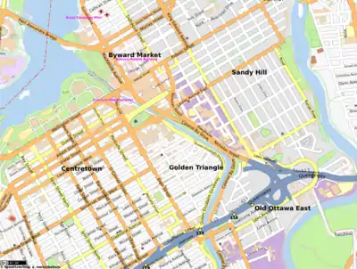
The Golden Triangle is a sub-neighbourhood of Centretown in Somerset Ward in central Ottawa, Ontario, Canada. It borders Elgin Street, at its west, and the Rideau Canal, at its east.[1] The Ottawa City Hall is to its north and the Elgin Street Police Station to its south. According to the 2016 Canada Census, the total population for this area was 5,778.[2]
It is dominated by large single-family homes although many have since been subdivided, but it contains some condominiums and small apartment buildings.[1]
Its main western thoroughfare, Elgin Street (nicknamed "Sens Mile"), is home to boutiques and galleries, and it is surrounded by restaurants, cafes, bars, and nightclubs. Its eastern thoroughfare, Queen Elizabeth Driveway, runs along the western edge of the Rideau Canal. Along the entire length of Queen Elizabeth Driveway is a multi-use trail, which is part of the Capital Pathway system.[3]
A series of explosions in the sewers caused property damage throughout the area on May 29, 1929.[4]

See also
- Corktown, a series of shanties along this section of the Rideau Canal that existed when the Canal was being built
- List of neighbourhoods in Ottawa
References
- 1 2 James Hale (5 April 2011). Frommer's Ottawa. John Wiley and Sons. pp. 59–. ISBN 978-0-470-68158-9. Retrieved 3 July 2011.
- ↑ Population calculated by combining Census Tract 0049.00 with Dissemination Block 35060338048 and Dissemination Areas 35060334, 35061716, 35061718, and 35060325
- ↑ "The Capital Pathway — National Capital Commission ::". National Capital Commission. 2010-06-10. Archived from the original on 2011-07-08. Retrieved 2010-06-23.
- ↑ Jeff Keshen; Nicole St-Onge (2 May 2001). Ottawa--making a capital. University of Ottawa Press. pp. 333–. ISBN 978-0-7766-0521-0. Retrieved 3 July 2011.
45°25′05″N 75°41′10″W / 45.418056°N 75.686111°W