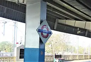
Gooty Junction | |
|---|---|
| Indian Railways station | |
 | |
| General information | |
| Location | NH 7, Gooty, Anantapur district, Andhra Pradesh |
| Elevation | 370 metres (1,210 ft) |
| Owned by | Indian Railways |
| Operated by | South Central Railways |
| Line(s) | Dharmavaram – Gooty line Chennai – Mumbai line Gooty – Dhone line |
| Platforms | 2 |
| Tracks | 5 |
| Construction | |
| Structure type | Standard on ground |
| Parking | Yes |
| Bicycle facilities | Yes |
| Accessible | Available |
| Other information | |
| Status | Functional |
| Station code | GY |
| Zone(s) | South Central Railway zone |
| Division(s) | Guntakal |
| History | |
| Electrified | Yes |
| Location | |
.svg.png.webp) Gooty Junction Location in Andhra Pradesh  Gooty Junction Location in India | |
Gooty Junction railway station (station code: GY[1]) is the primary railway station serving Gooty in Andhra Pradesh, India. The station comes under the jurisdiction of Guntakal division of South Central Railways.[2]
Structure and amenities
The station has two platforms. The station is situated at junction of four lines branching towards Dharmavaram Junction, Dhone Junction, Renigunta Junction and Guntakal Junction.
Gooty railway station is located on the Guntakal–Chennai Egmore section, which is part of Mumbai–Chennai railway route, it is home to one of the five diesel locomotive sheds in the South Coast Railways (SCR). Gooty Junction railway station is situated on the Bangalore – Hyderabad National Highway 7 (India)(old numbering)or 44, Ankola – Bellary – Gooty National Highway NH 63, Gulbarga – Gooty National Highway (In Process w.e.f 23/01/2014). Diesel Loco Shed, Gooty is home to diesel locomotives of the ALCO WDG-2A, WDG-3A, WDM-3A and WDM-3D classes.
Classification
Gooty railway station is classified as a B–category station in the Guntakal railway division.[3]
References
- ↑ "Station Code Index" (PDF). Portal of Indian Railways. 2015. p. 45. Retrieved 29 April 2019.
- ↑ "Gooty Junction".
- ↑ "Category of Stations over Guntakal Division". South Central Railway zone. Portal of Indian Railways. Archived from the original on 15 March 2016. Retrieved 22 February 2016.
15°08′59″N 77°37′30″E / 15.1496°N 77.6249°E