| Jialing River | |||||||||
|---|---|---|---|---|---|---|---|---|---|
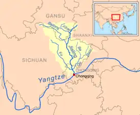
 The Jialing Basin | |||||||||
| Chinese | 嘉陵江 | ||||||||
| Literal meaning | Excellent Mound River | ||||||||
| |||||||||
| Former names | |||||||||
|---|---|---|---|---|---|---|---|---|---|
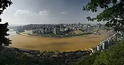
 The Jialing in Hechuan, Chongqing | |||||||||
| Ba River | |||||||||
| Chinese | 巴水 | ||||||||
| |||||||||
| Lang River | |||||||||
| Traditional Chinese | 閬水 | ||||||||
| Simplified Chinese | 阆水 | ||||||||
| |||||||||
| Yu River | |||||||||
| Chinese | 渝水 | ||||||||
| |||||||||
| Little River | |||||||||
| Chinese | 小河 | ||||||||
| |||||||||
The Jialing River,[lower-alpha 1] formerly known by numerous other names, is a major tributary of the Yangtze River in the Sichuan Basin.[2] It is named after the Jialing Valley in Feng County, Shaanxi through which it flows.
The Jialing River's most notable characteristic was formerly its pellucid green waters.[3] It is also notable for its sinuous course in its lower reaches. From Zhangwang Miao (Temple of Zhangfei) in Langzhong to the mouth, the distance as the crow flies is 223 kilometres (139 mi). However the river itself travels 680 kilometres (420 mi). The most tortuous part of its course is between Nanchong and Wusheng County.
Names
The name Jialing did not come into general use until the Tang Dynasty.[4] Before that, it was generally known as the Ba,[4] although it also appears as the Lang and Yu as well. In the 19th century, it was known by the Sichuanese as the Small[3][5] or Little River,[6][lower-alpha 2] by comparison with the Jinsha and Yangtze.
Geography

The source of the Jialing, in name, is in the Jialin, which means "the tomb of Jia (嘉陵)" in Chinese. Jia (赵代王嘉) was the last king of State Zhao (赵国), who was kidnapped to State Qin (now called Tianshui, Gansu Province, 甘肃省天水市) after Qin defeated Zhao.[7] The river briefly flows through Gansu before reentering Shaanxi and then crossing south into Sichuan.
The longest stem of the Jialing River, however, can be traced to a source in Aba Tibetan and Qiang Autonomous Prefecture, Sichuan and the entire river is 1,345 kilometres (836 mi) long.[8] This source is located at the head of the Baozuo River, considered a tributary of the Bailong River, itself the primary tributary and main stem of the Jialing River system. The branches named Jialing and Bailong meet in Guangyuan in Sichuan and continue as the Jialing to the Yangtze. The river reaches the floor of the Sichuan Basin at Langzhong and continues in a sinuous route into Chongqing and its junction with the Yangtze River.
Besides the Bailong River which forms a portion of the main stem, the largest tributaries of the Jialing River include the Xihan River, the Fu River (also known as Sui He), and the Qu River. The Xihan meets the Jialing in Shaanxi, while both the Fu and the Qu join the Jialing's respective right and left banks in Hechuan, Chongqing.
The cities along the Jialing's course include Tianshui, Baoji, Longnan, Guangyuan, Langzhong, Nanchong, and Chongqing. Cities found within the Jialing's basin and along its tributaries include Tianshui, Baoji, Longnan, Longnan, Mianyang, Suining, Bazhong, Wanyuan, Dazhou, and Guang'an.
Fauna
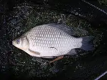
A total of 151 species of fish inhabit the river, of which 51 species are endemic to the Yangtze River basin.[9]

History
The Han and Jialing basins were the heartland of the ancient state of Ba, whose major cities were located at the sites of their tributaries' confluences.[10] The Jialing assumed greater importance when Chu expanded up the Han during the 5th and 4th centuries BC.[11]
The Jialing figures in one of the legends surrounding the Tang-era artist Wu Daozi. During the Kaiyuan Era of the Emperor Xuanzong, Wu was commissioned to depict the course of the Jialing and sent to Sichuan to travel its length for the work. Supposedly, he returned to the imperial palace and completed it in a single day from memory.[12][13] It is sometimes added that his technique was foiled by Li Sixun, who accompanied him and followed the traditional practice of working slowly from numerous prepared sketches.[14] To the extent that it is grounded in a real event, however, it probably only reflects Wu's speed of execution and not a lack of reliance on sketches.[15]
Around 1880, four out of Chongqing's 24 shipping guilds were concerned with shipping along the Jialing.[16] Chongqing, Lingshi, Lezhi, and Hechuan all developed shipyards.[17] In the 1920s, five of Chongqing's eight ferry guilds plied routes across the Jialing.[18]
Following the end of the Chinese Civil War in 1949, the river was repeatedly dredged and straightened until it was navigable throughout the year by the early 1970s.[19]
Notes
References
- ↑ "China", Encyclopædia Britannica, 9th ed., Vol. V, 1878.
- ↑ "Jialing River". Encyclopædia Britannica. Retrieved 12 January 2013.
- 1 2 3 Little, Archibald John, Through the Yang-tse Gorges, or, Trade and Travel in Western China, p. 254.
- 1 2 Fan Chengda; et al. (2008), Riding the River Home: A Complete and Annotated Translation of Fan Chengda's Diary of a Boat Trip to Wu (Wuchuan Lu), p. 166.
- 1 2 Parker, Edward Harper, Up the Yang-tse, p. 174.
- ↑ Chabrowski, p. 103 & 112.
- ↑ "天水赵氏肇始地望考释". 寻根. 2012. pp. 117–122.
- ↑ "Chinese scientists pinpoint source of Jialing River". China.org.cn. 24 January 2014. Retrieved 26 March 2014.
- ↑ "Patterns of Fishes Diversity in Jialing River and Resources Vicissitude in the Middle and Lower Basin". China Papers. Archived from the original on 25 March 2014. Retrieved 12 January 2013.
- ↑ Sage, Steven F., Ancient Sichuan and the Unification of China, p. 54.
- ↑ Sage, p. 64.
- ↑ Strassberg, Richard E. (ed.), Inscribed Landscapes: Travel Writing from Imperial China, p. 35.
- ↑ Chen Ju-yen and Late Yuan Painting in Suchou, p. 104.
- ↑ Van Briessen, Fritz (1964), The Way of the Brush: Painting Techniques of China and Japan, p. 52.
- ↑ Kao Yu-kung, "Chinese Lyric Aesthetics", Words and Images: Chinese Poetry, Calligraphy, and Painting, pp. 84–5.
- ↑ Chabrowski, Igor Iwo, Singing on the River: Sichuan Boatmen and Their Work Songs, 1880s–1930s, p. 70.
- ↑ Chabrowski, p. 72.
- ↑ Chabrowski, p. 80.
- ↑ "Inland Navigation", Summary of World Broadcasts: The Far East, Weekly Supplement, Pt. 3, 1974, p. 72.