Juncos
Municipio Autónomo de Juncos | |
|---|---|
Town and Municipality | |
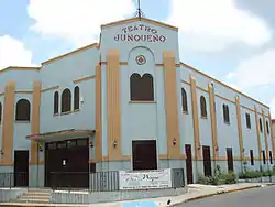
 Theater in Juncos | |
 Flag  Coat of arms | |
| Nicknames: "La Ciudad del Valenciano", "Los Mulos del Valenciano" | |
| Anthem: "Juncos Mi Pequeño París" | |
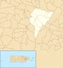
 Map of Puerto Rico highlighting Juncos Municipality | |
| Coordinates: 18°13′39″N 65°55′16″W / 18.22750°N 65.92111°W | |
| Sovereign state | United States |
| Commonwealth | Puerto Rico |
| Founded | August 2, 1797 |
| Barrios | |
| Government | |
| • Mayor | Alfredo Alejandro Carrión (PPD) |
| • Senatorial dist. | 7 – Humacao |
| • Representative dist. | 33 |
| Area | |
| • Total | 26.60 sq mi (68.89 km2) |
| • Land | 26.59 sq mi (68.86 km2) |
| • Water | 0.01 sq mi (0.03 km2) |
| Population (2020)[1] | |
| • Total | 37,012 |
| • Rank | 29th in Puerto Rico |
| • Density | 1,400/sq mi (540/km2) |
| Demonym | Junqueño |
| Ethnicity | |
| • White | 93.5% |
| • Black | 7.2% |
| • American Indian/AN | 0.0% |
| • Asian | 0.0% |
| • Native Hawaiian/PI | 0.0% |
| Time zone | UTC-4 (AST) |
| ZIP Code | 00777 |
| Area code | 787/939 |
| Major routes | |
Juncos (Spanish pronunciation: [ˈxuŋkos]) is a town and one of the 78 municipalities of Puerto Rico. It is located in the eastern central region of the island to the west of the Caguas Valley, south of Canóvanas and Carolina; southeast of Gurabo; east of San Lorenzo; and west of Las Piedras. Juncos is spread over 9 barrios and Juncos barrio-pueblo (the downtown area and administrative center of the city). It is part of the San Juan-Caguas-Guaynabo Metropolitan Statistical Area.
Juncos was founded on the request of Tomás Pizarro on August 2, 1797, having previously been a village which evolved from a small ranch, the Hatillo de los Juncos. This ranch was part of the Hato del Valenciano, which gave its name to the Río Valenciano which bisects the city before joining the Río Gurabo to the north of the settlement.
Juncos is Spanish for reeds.
History
During the 17th century, large parts of the municipality were owned by the Hato Grande de los Delgado (The Delgados' Great Ranch). Another ranch, the Hato del Valenciano, was established and later divided into the Hatillo de los Lirios and the Hatillo de los Juncos. This second one became the village of Juncos in the 18th century and was given the status of a town on August 2, 1797. Reeds, which gave the city its name, feature in the center of its flag and the bottom of its coat of arms. The Hato del Valenciano is remembered in the name of the Río Valenciano, as well as the coat of arms of Valencia featuring in Juncos' coat of arms, in addition to the city's two nicknames of La Ciudad del Valenciano (The Valenciano City) and Los Mulos del Valenciano (The Valenciano's Mules).[3]
Puerto Rico was ceded by Spain in the aftermath of the Spanish–American War under the terms of the Treaty of Paris of 1898 and became a territory of the United States. In 1899, the United States Department of War conducted a census of Puerto Rico finding that the population of Juncos was 8,429.[4]
On September 20, 2017 Hurricane Maria struck Puerto Rico. Juncos had been declared a disaster zone a week earlier when Hurricane Irma made landfall only to be hit again. Destruction to homes and infrastructure was estimated at $25 million.[5] Maria triggered numerous landslides in Juncos with its significant wind and rainfall.[6][7]
Symbols
The municipio has an official flag and coat of arms.[8]
Flag
On the flag of Juncos, on a gold field, blue waving stripes cross horizontally in the lower half. These represent the Río Valenciano which bisects the city. Green reeds with red buds appear in a central point above the stripes, representing the city's name (Juncos is Spanish for reeds).[9]
Coat of arms
Juncos' coat of arms is divided into four-quarters, with the upper left and lower right containing vertical stripes gold (or yellow) and gules (red) in reference to the Spanish region of Valencia and to its denomination as "Town of Valencia". The upper right quarter is blue with twelve silver stars to represent the Virgin Mary, and also features a cross confirming the city as part of Christendom. The lower right is split vertically between an image of a tobacco plant to represent the city's agriculture and a chimney to represent industrialization and sugar cane processing. Like the flag, a waving blue line representing the Río Valenciano crosses the shield horizontally.[9]
The shield is topped with a civic crown[10] in the shape of a three-towered castle. Underneath the shield lie the red-budded green reeds which gave the city its name, which features alongside its year of foundation (1797) at the very bottom.[3][9]
Geography
Juncos is in the central eastern part of the island.[11]
Barrios

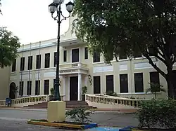
Like all municipalities of Puerto Rico, Juncos is subdivided into barrios. The municipal buildings, central square and large Catholic church are located near the center of the municipality, in a barrio referred to as "el pueblo".[12][13][14][15]
Sectors
Barrios (which are like minor civil divisions)[16] and subbarrios,[17] are further subdivided into smaller areas called sectores (sectors in English). The types of sectores may vary, from normally sector to urbanización to reparto to barriada to residencial, among others.[18][19][20]
Special Communities
Comunidades Especiales de Puerto Rico (Special Communities of Puerto Rico) are marginalized communities whose citizens are experiencing a certain amount of social exclusion. A map shows these communities occur in nearly every municipality of the commonwealth. Of the 742 places that were on the list in 2014, the following barrios, communities, sectors, or neighborhoods were in Juncos: Flores, Santana 1 in Ceiba Norte, Canta Gallo, El Caracol, La Cuesta in Sector El Mangó, La Hormiga, Lirios Dorados in Hoyo Hondo and Rosalía in Sector El Mangó.[21][22]
Climate
| Climate data for Juncos, Puerto Rico (1991–2020 normals, extremes 1931–present) | |||||||||||||
|---|---|---|---|---|---|---|---|---|---|---|---|---|---|
| Month | Jan | Feb | Mar | Apr | May | Jun | Jul | Aug | Sep | Oct | Nov | Dec | Year |
| Record high °F (°C) | 96 (36) |
95 (35) |
94 (34) |
96 (36) |
97 (36) |
96 (36) |
100 (38) |
98 (37) |
99 (37) |
97 (36) |
96 (36) |
98 (37) |
100 (38) |
| Mean daily maximum °F (°C) | 82.3 (27.9) |
82.8 (28.2) |
83.6 (28.7) |
85.1 (29.5) |
86.1 (30.1) |
87.5 (30.8) |
88.1 (31.2) |
88.5 (31.4) |
88.5 (31.4) |
87.3 (30.7) |
85.0 (29.4) |
83.0 (28.3) |
85.6 (29.8) |
| Daily mean °F (°C) | 73.6 (23.1) |
73.7 (23.2) |
74.5 (23.6) |
76.4 (24.7) |
78.4 (25.8) |
79.9 (26.6) |
80.1 (26.7) |
80.4 (26.9) |
80.3 (26.8) |
79.2 (26.2) |
77.1 (25.1) |
74.7 (23.7) |
77.4 (25.2) |
| Mean daily minimum °F (°C) | 65.0 (18.3) |
64.7 (18.2) |
65.4 (18.6) |
67.6 (19.8) |
70.6 (21.4) |
72.2 (22.3) |
72.2 (22.3) |
72.3 (22.4) |
72.0 (22.2) |
71.1 (21.7) |
69.2 (20.7) |
66.4 (19.1) |
69.1 (20.6) |
| Record low °F (°C) | 50 (10) |
50 (10) |
50 (10) |
50 (10) |
50 (10) |
58 (14) |
57 (14) |
58 (14) |
56 (13) |
55 (13) |
51 (11) |
42 (6) |
42 (6) |
| Average precipitation inches (mm) | 3.27 (83) |
2.48 (63) |
2.86 (73) |
4.78 (121) |
6.39 (162) |
5.24 (133) |
7.04 (179) |
7.22 (183) |
8.73 (222) |
7.60 (193) |
7.69 (195) |
4.17 (106) |
67.47 (1,714) |
| Average precipitation days (≥ 0.01 in) | 16.0 | 14.0 | 11.8 | 12.8 | 17.0 | 15.3 | 16.4 | 16.5 | 16.4 | 16.6 | 18.8 | 17.5 | 189.1 |
| Source: NOAA[23][24] | |||||||||||||
Demographics
| Census | Pop. | Note | %± |
|---|---|---|---|
| 1900 | 8,429 | — | |
| 1910 | 11,692 | 38.7% | |
| 1920 | 13,151 | 12.5% | |
| 1930 | 17,469 | 32.8% | |
| 1940 | 19,464 | 11.4% | |
| 1950 | 21,654 | 11.3% | |
| 1960 | 21,496 | −0.7% | |
| 1970 | 21,814 | 1.5% | |
| 1980 | 25,397 | 16.4% | |
| 1990 | 30,612 | 20.5% | |
| 2000 | 36,452 | 19.1% | |
| 2010 | 40,290 | 10.5% | |
| 2020 | 37,012 | −8.1% | |
| U.S. Decennial Census[25] 1899 (shown as 1900)[26] 1910–1930[27] 1930–1950[28] 1960–2000[29] 2010[14] 2020[30] | |||
Tourism

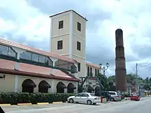
- Juncos Sugar Mill
- Old Tobacco Farm
- Juncos Plaza Shopping Center
- Paseo Escuté
- El Tenedor Restaurant[31]
- Casa Vieja Cafe
- Teatro Junqueño (Juncos Theater)
Culture
Festivals and events
Juncos celebrates its patron saint festival in December. The Fiestas Patronales Inmaculada Concepcion de Maria is a religious and cultural celebration that generally features parades, games, artisans, amusement rides, regional food, and live entertainment.[11]
Other festivals and events celebrated in Juncos include:
- Modesto Carrión International Marathon – November
- La Mina Christian Music fest – July
- Plenazo Junqueño – February
Economy
In the fertile plains of the Río Valenciano, coffee, fruits, sugar cane and tobacco are grown. The lower left quarter of the municipal coat of arms pay homage to tobacco cultivation and sugar cane processing.
Apparel, electronic machinery and electrical equipment, scientific instruments, pharmaceutical and biotechnology industries
Amgen, a biopharmaceutical company, has developed its largest manufacturing site in Juncos. It is a biotechnology campus for bulk manufacturing, with laboratories and manufacturing facilities that employs close to 3000 people.[32] Amgen Puerto Rico received FDA approval for bulk manufacturing facilities for Nepogen (filgrastim), Neulasta (pegfilgrastim), Aranesp and Epogen. Amgen is also adding manufacturing capacity in Juncos to produce Denosumab.
In addition to Amgen there is a Medtronic and Becton Dickinson Caribe Ltd. in Juncos. The Colgate pharmaceutical facility has closed and production shifted to Mexico.
Government

Alfredo Alejandro Carrión of the People's Democratic Party is the incumbent mayor of the municipality of Juncos, since the year 2000.
The city belongs to the Senatorial District of Humacao (District VII), which is represented by two senators. The current senators are Rosamar Trujillo Plumey (PPD) and Wanda Soto Tolentino (PNP).
The city is part of the 33 Representative District, which is represented by one representative. The current representative is Ángel Peña Ramírez of the New Progressive Party since 2008.
Transportation
There are 28 bridges in Juncos.[33]
Under the administration of Alfredo "Papo" Alejandro, Juncos started a collective ferry-on-wheels transportation system.
Sports
Roberto Clemente Walker, later a double-World Series winner for the Pittsburgh Pirates, played baseball for Juncos before signing with the Santurce Crabbers in Puerto Rico's Professional League. As is the national norm, volleyball and basketball are biggest sports in Juncos. In the year 2006–2007 the Valencianas de Juncos won the women's basketball and volleyball superior league national championship. In 2009, Juncos became the home of the 2008 Puerto Rico Soccer League champions, Sevilla Bayamon FC. The club is now known as Sevilla-FC Juncos since being relocated to the city. The team moved to Juncos due to ownership and financial problems and currently play in the Alfredo "Papo" Alejandro Stadium.
Natives
See also
References
- ↑ Bureau, US Census. "PUERTO RICO: 2020 Census". The United States Census Bureau. Retrieved August 25, 2021.
- ↑ "Demographics/Ethnic U.S 2000 census" (PDF). Archived (PDF) from the original on February 16, 2008. Retrieved March 16, 2013.
- 1 2 "Juncos (Puerto Rico)". Archived from the original on August 4, 2012. Retrieved September 29, 2012.
- ↑ Joseph Prentiss Sanger; Henry Gannett; Walter Francis Willcox (1900). Informe sobre el censo de Puerto Rico, 1899, United States. War Dept. Porto Rico Census Office. Washington : Govt. print. off. p. 160.
- ↑ "María, un nombre que no vamos a olvidar. Juncos fue rematado por dos huracanes" [Juncos was finished by two hurricanes]. El Nuevo Día (in Spanish). June 13, 2019. Retrieved September 11, 2022.
- ↑ "Preliminary Locations of Landslide Impacts from Hurricane Maria, Puerto Rico". USGS Landslide Hazards Program. USGS. Archived from the original on March 3, 2019. Retrieved March 3, 2019.
- ↑ "Preliminary Locations of Landslide Impacts from Hurricane Maria, Puerto Rico" (PDF). USGS Landslide Hazards Program. USGS. Archived (PDF) from the original on March 3, 2019. Retrieved March 3, 2019.
- ↑ "Ley Núm. 70 de 2006 -Ley para disponer la oficialidad de la bandera y el escudo de los setenta y ocho (78) municipios". LexJuris de Puerto Rico (in Spanish). Retrieved June 15, 2021.
- 1 2 3 "JUNCOS". LexJuris (Leyes y Jurisprudencia) de Puerto Rico (in Spanish). February 19, 2020. Archived from the original on February 19, 2020. Retrieved September 17, 2020.
- ↑ http://www.gencat.cat/municat/escuts/heraldica/timbres.htm Archived July 22, 2011, at the Wayback Machine (in Catalan)
- 1 2 "Juncos Municipality". enciclopediapr.org. Fundación Puertorriqueña de las Humanidades (FPH. Archived from the original on August 23, 2020. Retrieved March 20, 2019.
- ↑ Picó, Rafael; Buitrago de Santiago, Zayda; Berrios, Hector H. (1969). Nueva geografía de Puerto Rico: física, económica, y social, por Rafael Picó. Con la colaboración de Zayda Buitrago de Santiago y Héctor H. Berrios. San Juan Editorial Universitaria, Universidad de Puerto Rico,1969. Archived from the original on December 26, 2018. Retrieved December 31, 2018.
- ↑ Gwillim Law (May 20, 2015). Administrative Subdivisions of Countries: A Comprehensive World Reference, 1900 through 1998. McFarland. p. 300. ISBN 978-1-4766-0447-3. Retrieved December 25, 2018.
- 1 2 Puerto Rico:2010:population and housing unit counts.pdf (PDF). U.S. Dept. of Commerce Economics and Statistics Administration U.S. Census Bureau. 2010. Archived (PDF) from the original on February 20, 2017. Retrieved December 31, 2018.
- ↑ "Map of Juncos at the Wayback Machine" (PDF). Archived from the original (PDF) on March 24, 2018. Retrieved December 29, 2018.
- 1 2 "US Census Barrio-Pueblo definition". factfinder.com. US Census. Archived from the original on May 13, 2017. Retrieved January 5, 2019.
- ↑ "P.L. 94-171 VTD/SLD Reference Map (2010 Census): Juncos Municipio, PR" (PDF). www2.census.gov. U.S. DEPARTMENT OF COMMERCE Economics and Statistics Administration U.S. Census Bureau. Archived (PDF) from the original on August 23, 2020. Retrieved August 22, 2020.
- ↑ "Agencia: Oficina del Coordinador General para el Financiamiento Socioeconómico y la Autogestión (Proposed 2016 Budget)". Puerto Rico Budgets (in Spanish). Archived from the original on June 28, 2019. Retrieved June 28, 2019.
- ↑ Rivera Quintero, Marcia (2014), El vuelo de la esperanza: Proyecto de las Comunidades Especiales Puerto Rico, 1997–2004 (first ed.), San Juan, Puerto Rico Fundación Sila M. Calderón, ISBN 978-0-9820806-1-0
- ↑ "Leyes del 2001". Lex Juris Puerto Rico (in Spanish). Archived from the original on September 14, 2018. Retrieved June 24, 2020.
- ↑ Rivera Quintero, Marcia (2014), El vuelo de la esperanza:Proyecto de las Comunidades Especiales Puerto Rico, 1997–2004 (Primera edición ed.), San Juan, Puerto Rico Fundación Sila M. Calderón, p. 273, ISBN 978-0-9820806-1-0
- ↑ "Comunidades Especiales de Puerto Rico" (in Spanish). August 8, 2011. Archived from the original on June 24, 2019. Retrieved June 24, 2019.
- ↑ "NowData – NOAA Online Weather Data". National Oceanic and Atmospheric Administration. Retrieved June 17, 2021.
- ↑ "Station: Juncos 1 SE, PR PQ". U.S. Climate Normals 2020: U.S. Monthly Climate Normals (1991–2020). National Oceanic and Atmospheric Administration. Retrieved June 17, 2021.
- ↑ "U.S. Decennial Census". United States Census Bureau. Archived from the original on February 13, 2020. Retrieved September 21, 2017.
- ↑ "Report of the Census of Porto Rico 1899". War Department Office Director Census of Porto Rico. Archived from the original on July 16, 2017. Retrieved September 21, 2017.
- ↑ "Table 3-Population of Municipalities: 1930 1920 and 1910" (PDF). United States Census Bureau. Archived (PDF) from the original on August 17, 2017. Retrieved September 21, 2017.
- ↑ "Table 4-Area and Population of Municipalities Urban and Rural: 1930 to 1950" (PDF). United States Census Bureau. Archived (PDF) from the original on August 30, 2015. Retrieved September 21, 2014.
- ↑ "Table 2 Population and Housing Units: 1960 to 2000" (PDF). United States Census Bureau. Archived (PDF) from the original on July 24, 2017. Retrieved September 21, 2017.
- ↑ Bureau, US Census. "PUERTO RICO: 2020 Census". The United States Census Bureau. Retrieved August 25, 2021.
- ↑ Túa, Lynet Santiago. "El Tenedor, delicioso steak house en Juncos con mucha historia". Metro. Archived from the original on November 1, 2019. Retrieved November 1, 2019.
- ↑ Inc, Poseida Therapeutics. "Poseida Therapeutics Appoints Kerry Ingalls as Chief Operating Officer". www.prnewswire.com. Archived from the original on November 1, 2019. Retrieved November 1, 2019.
{{cite web}}:|last=has generic name (help) - ↑ "Juncos Bridges". National Bridge Inventory Data. US Dept. of Transportation. Archived from the original on February 20, 2019. Retrieved February 19, 2019.
Further reading
- Mapa de municipios y barrios - Juncos - Memoria Núm. 50 (PDF). University of Puerto Rico: Estado Libre Asociado de Puerto Rico, Oficina del Gobernador, Junta de Planificacion, Santurce, Puerto Rico. 1955.