29°27′13″N 30°34′51″E / 29.45361°N 30.58083°E
| Lake Moeris | |||||||||||
|---|---|---|---|---|---|---|---|---|---|---|---|
| Location | Faiyum Governorate, Egypt | ||||||||||
| Primary inflows | Nile River (via the Bahr Yussef) | ||||||||||
| Basin countries | Egypt | ||||||||||
| Surface area | Varies (previously estimated between 1,270 km2 (490 sq mi) and 1,700 km2 (660 sq mi)) | ||||||||||
| Surface elevation | 43 m (141 ft) below sea-level | ||||||||||
| Frozen | No | ||||||||||
| Settlements | Cairo | ||||||||||
| |||||||||||
Lake Moeris (Ancient Greek: Μοῖρις, genitive Μοίριδος) is an ancient artificially-fed endorheic lake in the northwest of the Faiyum Oasis, 80 km (50 mi) southwest of Cairo, Egypt. In prehistory, it was a freshwater lake, with an area estimated to vary between 1,270 km2 (490 sq mi) and 1,700 km2 (660 sq mi).
It persists today as a much smaller saltwater lake called Birket Qarun.[2] The lake's surface is 43 m (141 ft) below sea-level, and covers about 202 square kilometres (78 sq mi). The lake and surrounding area is a protected area and has been designated as a Ramsar site since 2012.[1]
It is a source for tilapia and other fish from the local area.
The prehistoric mammal Moeritherium was found in this area.
History
When the Mediterranean Sea was a hot dry hollow near the end of the Messinian Salinity Crisis in the late Miocene, Faiyum was a dry hollow, and the Nile flowed past it at the bottom of a canyon (2,400 m deep or more where Cairo is now). After the Mediterranean reflooded at the end of the Miocene, the Nile canyon became an arm of the sea reaching inland farther than Aswan. Over geological time that sea arm gradually filled with silt and became the Nile valley.
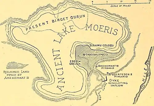
Eventually, the Nile valley bed silted up high enough for the flooding Nile to overflow into the Faiyum hollow, making a lake in it; however, for the most part it could only be fed intermittently, by high flood waters. The lake was bordered by neolithic settlements, and the town of Shedet grew up on the south where the higher ground created a ridge. The lake is first recorded from about 3000 BCE, around the time of Narmer (Menes).
In 2300 BCE, the waterway from the Nile to the natural lake was widened and deepened to make a canal, now known as the Bahr Yussef, to better feed the lake. The project was started by Amenemhat III, or perhaps by his father Senusret III, and served three purposes:
- Control the flooding of the Nile
- Regulate the water level of the Nile during dry seasons
- Provide the surrounding area with irrigation water
There is evidence of ancient Egyptian pharaohs of the twelfth dynasty using the natural lake of Faiyum as a reservoir to store surpluses of water for use during the dry periods.
The lake was also used as part of a freight transport system: The remnants of the Lake Moeris Quarry Road, the oldest known paved road in the world, were found near the lake. It was used to convey basalt blocks from a nearby quarry to the lake; from the lake the blocks could be shipped to the Giza Necropolis for building and monument construction projects. The ASCE has entered it into its List of Historic Civil Engineering Landmarks.[3][4]
Herodotus claims to have visited the lake in his book Histories, situating it below the Labyrinth of Egypt and opposite the ancient city Crocodilopolis (i.e., the modern city of Fayyum).[5] Herodotus also states that "two pyramids" (interpreted to be the Pedestals of Biahmu) stood in the middle of the lake[6] – a claim that led the British Egyptologist W.M.F. Petrie to hypothesize that the lake was flooded when Herodotus had visited the area.[7]
The immense waterworks undertaken by the ancient Egyptian pharaohs of the twelfth dynasty to transform the lake into a huge water reservoir gave the impression that the lake was an artificial excavation, as reported by geographers and travelers during classical times.[8] However, as the Classicist Alan B. Lloyd notes, this is erroneous:
- "The Fayum basin is a natural formation created by wind erosion. The lake was created when an offshoot of the Nile, now known as the Bahr Yusuf, broke through the western cliffs and flooded the lower part of the basin."[9]
Etymology
| mer-wer (Moeris) in hieroglyphs | |||
|---|---|---|---|
The name "Lake Moeris" is derived from the Greek translation (i.e., "Limne Moeris" Μοῖρῐς λίμνη) of the Egyptian place-name mr-wr, which means "Great Canal".[10] The canal in question was likely the Bahr Yussef, and as the pharaoh responsible for its construction, Amenemhat III was referred to by the Greek as "King Moeris".[10][11] During the time of Late Egyptian, the lake was referred to as the Piôm, a name derived from the Egyptian phrase pꜣ-ym (lit. "the Sea").[12][13]
References
- 1 2 "Lake Qarun Protected Area". Ramsar Sites Information Service. Retrieved 25 April 2018.
- ↑ "Lake Moeris". Brown University. Retrieved 2018-08-14.
- ↑ "Lake Moeris Quarry Road". asce.org. American Society of Civil Engineers. Retrieved 2022-01-26.
- ↑ Wilford, John Noble (8 May 1994). "World's oldest paved road found in Egypt". The New York Times. Retrieved 2018-08-29.
- ↑ Herodotus. Histories. 2.148–150.
- ↑ Lloyd, Alan B. (1975). Herodotus: Book II Commentary 99-182. Leiden, NL: Brill Publishers. p. 126. ISBN 978-90-04-07737-9.
- ↑ Petrie, W.M.F. (1889). Hawara, Biahmu, and Arsinoe. London, UK: Field & Tuer. Retrieved October 4, 2022.
- ↑ Hyvernat, Eugène Xavier Louis Henri (1913). . In Herbermann, Charles (ed.). Catholic Encyclopedia. New York: Robert Appleton Company.
- ↑ Lloyd, Alan B. (2002). "Egypt". In Bakker, Egbert J.; de Jong, Irene J. F.; van Wees, Hans (eds.). Brill's Companion to Herodotus. Leiden, Netherlands: Brill Publishers. p. 429. Retrieved April 20, 2023.
- 1 2 Wendrich, Willeke; Holdaway, Simon J. (2017). "Landscape archaeology of the desert Fayum". In Holdaway, Simon J.; Wendrich, Willeke (eds.). The Desert Fayum Reinvestigated: The early to mid-Holocene landscape archaeology of the Fayum north shore, Egypt. Los Angeles, CA: The Cotsen Institute of Archaeology Press. p. 1. ISBN 9781938770500. Retrieved April 20, 2023.
- ↑ Negm, Abdelazim M.; Abdel-Fattah, Sommer, eds. (2018). Grand Ethiopian Renaissance Dam Versus Aswan High Dam: A view from Egypt. Cham, Switzerland: Springer. p. 361.
- ↑ Chisholm, Hugh, ed. (1911). "Moeris, Lake of". Encyclopædia Britannica (11th ed.). Cambridge University Press.
- ↑ Lesko, L. H.; Lesko, B. S., eds. (2002). A Dictionary of Late Egyptian. Vol. 1 (2nd ed.). Providence, RI: B.C. Scribe Publications. pp. 28, 145.
Sources
- "Fayum Project". trismegistos.org. University of Leuven.
- Chanson, Hubert (1999). "Study of the Moeris reservoir, the Ha-Uar Dam and the canal connecting the Nile River and Lake Moeris". The Hydraulics of Open Channel Flow: An introduction (textbook) (1st ed.). Butterworth-Heinemann / Elsevier Science, Technology, & Business. Major Problem 2. Archived from the original on 2008-01-13 – via bh.com.
- Attribution
- This article incorporates text from a publication now in the public domain: Griffith, Francis Llewellyn (1911). "Moeris, Lake of". In Chisholm, Hugh (ed.). Encyclopædia Britannica (11th ed.). Cambridge University Press.
External links
- . Encyclopedia Americana. 1920.
- . The American Cyclopædia. 1879.