Leer | |
|---|---|
 Flag  Coat of arms | |
| Country | Germany |
| State | Lower Saxony |
| Capital | Leer |
| Area | |
| • Total | 1,086 km2 (419 sq mi) |
| Population (31 December 2021)[1] | |
| • Total | 172,421 |
| • Density | 160/km2 (410/sq mi) |
| Time zone | UTC+01:00 (CET) |
| • Summer (DST) | UTC+02:00 (CEST) |
| Vehicle registration | LER |
| Website | landkreis-leer.de |
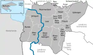
Leer is a district (Landkreis) in Lower Saxony, Germany. It is bounded by (from the northwest and clockwise) the city of Emden, the districts of Aurich, Wittmund, Friesland, Ammerland, Cloppenburg and Emsland, and by the Netherlands (Province of Groningen).
History
In 1744, East Frisia was annexed by Prussia. In 1867, the region was subdivided into districts, and the districts of Leer and Weener were established. In 1932, these two districts were merged.
Geography
The District is located in the southern part of East Frisia. The Ems River runs through the District, coming out of the Emsland in the south and flowing into the Dollart, a bay of the North Sea. The island of Borkum, belonging to the East Frisian Islands, is also a part of the District. Some of the area of the District is in the Lower Saxony Wadden Sea National Park.
Coat-of-arms
The coat-of-arms is identical to the arms of the East Frisian chieftain dynasty Ukena, rulers of the area during the 15th century. Its blazon is: "Arms: Azure, a lion rampant dexter-facing Argent armed and langued Gules, collared by a wreath of leaves proper. Crown: two plumes of wheat Vert divided by a four-leaf clover proper at center."
Cities and municipalities

| Cities | Samtgemeinden |
|---|---|
|
|
|
| 1seat of the Samtgemeinde |
Unincorporated Area
The uninhabited island Lütje Hörn is also part of Leer district, but not part of any municipality (unincorporated area).
References
External links
![]() Media related to Landkreis Leer at Wikimedia Commons
Media related to Landkreis Leer at Wikimedia Commons
- Official website (in German)
- Borkum island (in German, Dutch, and English)