Les Lacs-du-Témiscamingue | |
|---|---|
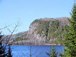 Lacs-du-Témiscamingue as seen across the Ottawa River near Mattawa | |
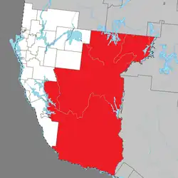 Location within Témiscamingue RCM | |
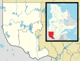 Les Lacs-du-Témiscamingue Location in western Quebec | |
| Coordinates: 47°04′N 78°26′W / 47.067°N 78.433°W[1] | |
| Country | Canada |
| Province | Quebec |
| Region | Abitibi-Témiscamingue |
| RCM | Témiscamingue |
| Constituted | October 31, 2005 |
| Government | |
| • Federal riding | Abitibi—Témiscamingue |
| • Prov. riding | Rouyn-Noranda–Témiscamingue |
| Area | |
| • Total | 12,224.27 km2 (4,719.82 sq mi) |
| • Land | 10,366.89 km2 (4,002.68 sq mi) |
| Population (2021)[3] | |
| • Total | 10 |
| • Density | 0.0/km2 (0/sq mi) |
| • Pop (2016–21) | |
| • Dwellings | 15 |
| Time zone | UTC−05:00 (EST) |
| • Summer (DST) | UTC−04:00 (EDT) |
Les Lacs-du-Témiscamingue (French, meaning "The Lakes of Temiscaming") is a large unorganized territory in the Abitibi-Témiscamingue region of Quebec, Canada. With a total area of 12,224.27 square kilometres (4,719.82 sq mi), it takes up over 60% of the eastern portion of the Témiscamingue Regional County Municipality.[2]
The only community in the territory is the hamlet of Lac-Caugnawana (46°32′06″N 78°18′23″W / 46.53500°N 78.30639°W).[4]
Until October 31, 2005, Les Lacs-du-Témiscamingue and Laniel unorganized territories were part of the Rivière-Kipawa unorganized territory.[5]
Demographics
Canada census – Les Lacs-du-Témiscamingue community profile
| 2021 | 2016 | |
|---|---|---|
| Population | 10 (-33.3% from 2016) | 15 (--% from 2011) |
| Land area | 10,366.89 km2 (4,002.68 sq mi) | 10,418.36 km2 (4,022.55 sq mi) |
| Population density | 0.0/km2 (0/sq mi) | 0.0/km2 (0/sq mi) |
| Median age | ||
| Private dwellings | 15 (total) 6 (occupied) | 20 (total) 5 (occupied) |
| Median household income |
| Year | Pop. | ±% |
|---|---|---|
| 2001 | 0 | — |
| 2006 | 5 | — |
| 2011 | 0 | −100.0% |
| 2016 | 15 | — |
| 2021 | 10 | −33.3% |
| 2001 population figure adjusted due to boundary change. Source: Statistics Canada | ||
See also
References
- ↑ "Banque de noms de lieux du Québec: Reference number 390267". toponymie.gouv.qc.ca (in French). Commission de toponymie du Québec.
- 1 2 3 "Répertoire des municipalités: Geographic code 85907". www.mamh.gouv.qc.ca (in French). Ministère des Affaires municipales et de l'Habitation. Retrieved 2023-12-12.
- 1 2 "Les Lacs-du-Témiscamingue (Code 2485907) Census Profile". 2021 census. Government of Canada - Statistics Canada. Retrieved 2023-12-12.
- ↑ "Banque de noms de lieux du Québec: Lac-Caugnawana (hameau)". toponymie.gouv.qc.ca (in French). Commission de toponymie du Québec. Retrieved 2023-12-12.
- ↑ "Modifications aux municipalités du Québec – Octobre 2005" (PDF). stat.gouv.qc.ca. Institut de la statistique du Québec. October 2005. Archived from the original (PDF) on 30 December 2006. Retrieved 30 June 2022.
- ↑ "2021 Community Profiles". 2021 Canadian Census. Statistics Canada. February 4, 2022. Retrieved 2023-12-12.
- ↑ "2016 Community Profiles". 2016 Canadian Census. Statistics Canada. August 12, 2021. Retrieved 2023-12-12.
- ↑ "2006 Community Profiles". 2006 Canadian Census. Statistics Canada. August 20, 2019.
- ↑ "2001 Community Profiles". 2001 Canadian Census. Statistics Canada. July 18, 2021.
External links
![]() Media related to Les Lacs-du-Témiscamingue at Wikimedia Commons
Media related to Les Lacs-du-Témiscamingue at Wikimedia Commons
Adjacent Municipal Subdivisions | |
|---|---|
| Cities | |
|---|---|
| Municipalities | |
| Townships |
|
| Parishes | |
| Unorganized territories | |
| |
This article is issued from Wikipedia. The text is licensed under Creative Commons - Attribution - Sharealike. Additional terms may apply for the media files.