Los Rios | |
|---|---|
Province | |
| Provincia de Los Rios | |
 Flag | |
.svg.png.webp) Location of Los Rios Province in Ecuador. | |
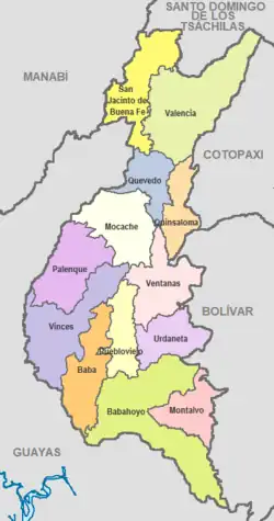
 Cantons of Los Ríos Province | |
| Country | Ecuador |
| Created | October 6, 1860. |
| Founded by | Legislative decree. |
| Named for | High number of existing rivers. |
| Capital | Babahoyo |
| Cantons | List of Cantons |
| Government | |
| • Type | Provincial |
| Area | |
| • Total | 7,238 km2 (2,795 sq mi) |
| Population (2022 census)[1] | |
| • Total | 898,652 |
| • Density | 120/km2 (320/sq mi) |
| • Urban | 326,122 |
| • Population 2001 | 668,309 |
| Time zone | UTC-5 (ECT) |
| Vehicle registration | R |
| HDI (2017) | 0.705[2] high · 22nd |
| Website | www |

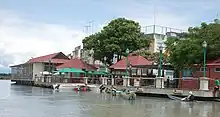
New Muelle Municipal, Babahoyo
Los Ríos (Spanish pronunciation: [los ˈri.os]) is a province in Ecuador. The capital is Babahoyo. The province was founded on October 6, 1860. Under legislative decree. Babahoyo was made its capital on September 30, 1948.
Demographics
Ethnic groups as of the Ecuadorian census of 2010:[3]
- Mestizo 52.9%
- Montubio 35.1%
- Afro-Ecuadorian 6.2%
- White 5.0%
- Indigenous 0.6%
- Other 0.3%
Economy
The province's economy is largely based on its agriculture: coffee, cacao, bananas, rice, tobacco, etc. Its small industrial sector produces paper, sugar, and wood crafts. Recently developed tourist attractions include fishing and native rituals.
Cantons
The province is divided into 13 cantons. The following table lists each with its population at the time of the 2010 census, its area in square kilometres (km²), and the name of the canton seat or capital.[4]
| Canton | Pop. (2010) | Area (km²) | Seat/Capital |
|---|---|---|---|
| Baba | 39,681 | 516 | Baba |
| Babahoyo | 153,773 | 1,076 | Babahoyo |
| Buena Fé | 63,148 | 569 | San Jacinto de Buena Fe |
| Mocache | 38,392 | 562 | Mocache |
| Montalvo | 24,164 | 362 | Montalvo |
| Palenque | 22,320 | 570 | Palenque |
| Pueblo Viejo | 36,477 | 338 | Puebloviejo |
| Quevedo | 173,575 | 303 | Quevedo |
| Quinsaloma | 16,476 | 280 | Quinsaloma |
| Urdaneta | 29,263 | 377 | Catarama |
| Valencia | 42,556 | 980 | Valencia |
| Ventanas | 71,093 | 288 | Ventanas |
| Vinces | 71,736 | 693 | Vinces |
See also
Wikimedia Commons has media related to Los Ríos Province.
References
- ↑ Citypopulation.de
- ↑ Villalba, Juan. "Human Development Index in Ecuador". Scribd (in Spanish). Retrieved 2019-02-05.
- ↑ Censos, Instituto Nacional de Estadística y. "Resultados -". www.ecuadorencifras.gob.ec. Retrieved 17 April 2018.
- ↑ Cantons of Ecuador. Statoids.com. Retrieved 4 November 2009.
This article is issued from Wikipedia. The text is licensed under Creative Commons - Attribution - Sharealike. Additional terms may apply for the media files.