Staufenberg | |
|---|---|
 | |
 Coat of arms | |
Location of Staufenberg within Göttingen district  | |
 Staufenberg 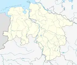 Staufenberg | |
| Coordinates: 51°21′00″N 09°35′59″E / 51.35000°N 9.59972°E | |
| Country | Germany |
| State | Lower Saxony |
| District | Göttingen |
| Government | |
| • Mayor (2021–26) | Bernd Grebenstein[1] |
| Area | |
| • Total | 77.55 km2 (29.94 sq mi) |
| Elevation | 288 m (945 ft) |
| Population (2021-12-31)[2] | |
| • Total | 7,687 |
| • Density | 99/km2 (260/sq mi) |
| Time zone | UTC+01:00 (CET) |
| • Summer (DST) | UTC+02:00 (CEST) |
| Postal codes | 34355 |
| Dialling codes | 05543 |
| Vehicle registration | GÖ |
| Website | www.staufenberg-nds.de |
Staufenberg is the southernmost municipality of the district of Göttingen, and of Lower Saxony, Germany. It is situated east of the river Fulda, approx. 6 km south of Hannoversch Münden, and 12 km northeast of Kassel. Its seat is in the village Landwehrhagen.
Points of interest
References
This article is issued from Wikipedia. The text is licensed under Creative Commons - Attribution - Sharealike. Additional terms may apply for the media files.