Mahoba district | |
|---|---|
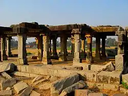
 Chandela-era Yajna Mandapa in Kulpahar | |
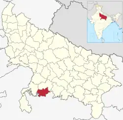
 Location of Mahoba district in Uttar Pradesh | |
| Coordinates (Mahoba): 25°17′24″N 79°52′12″E / 25.29000°N 79.87000°E | |
| Country | |
| State | Uttar Pradesh |
| Division | Chitrakoot Division |
| Headquarters | Mahoba |
| Tehsils | 1. Kulpahar 2. Charkhari 3. Mahoba |
| Government | |
| • District Magistrate & Collector | Mridul Chaudhary |
| • Vidhan Sabha constituencies | Mahoba and Charkhari |
| Area | |
| • Total | 3,144 km2 (1,214 sq mi) |
| Population (2011) | |
| • Total | 875,958 |
| • Density | 279/km2 (720/sq mi) |
| • Urban | 185,381 |
| Time zone | UTC+05:30 (IST) |
| Major highways | 86 |
| Website | mahoba |
Mahoba district is one of the districts of Uttar Pradesh state of India and Mahoba city is the district headquarters. Mahoba district is a part of Chitrakoot Division. The district occupies an area of 2884 km². It has a population of 875,958 (2011 census). As of 2011 it is the least populous district of Uttar Pradesh (out of 75).[1] Mahoba District is also known as Alha-Udal Nagari.
Divisions
The district comprises three tehsils: Mahoba, Charkhari and Kulpahar, comprising four development blocks: Kabrai, Charkhari, Jaitpur and Panwari.
There are five urban local bodies (two Nagar Palika Parishads and three Nagar Panchayats): Mahoba (NPP), Charkhari (NPP), Kabrai (NP), Kulpahar (NP) and Kharela (NP).
There are 10 police stations including woman police station in the district.
There are two Vidhan Sabha constituencies in this district: Mahoba and Charkhari. Both are part of Hamirpur Lok Sabha constituency.
General administration
The district is a part of Chitrakoot division, headed by the Divisional Commissioner, who is an IAS officer of high seniority.[2][3][4][5][6] The District Magistrate & Collector, hence, reports to the Divisional Commissioner of Chitrakoot Division. The current Divisional Commissioner is Dinesh Kumar Singh (IAS).
Mahoba district administration is headed by the District Magistrate & Collector (DM), who is an IAS officer. The DM is in charge of land revenue, law and order and supervises all development activities the district.[2][7][8][9][10]
The District Magistrate is assisted by one Chief Development Officer, one Additional District Magistrate i.e. ADM (Finance & Revenue), and three Sub Divisional Magistrates. The current DM of Mahoba is Manoj Kumar Chauhan (IAS).
Police administration
Mahoba district comes under Prayagraj police zone and Chitrakoot police range of Uttar Pradesh Police. Prayagraj zone is headed by an IPS officer in the rank of Additional Director General of Police (ADG), whereas Chitrakoot range is headed by an IPS officer in the rank of Inspector General of Police (IG).
District Police of Mahoba is headed by the Superintendent of Police (SP) who is an IPS officer and is accountable to the District Magistrate for Law and Order enforcement. He is assisted by one Additional Superintendent of Police. The Mahoba district is divided into three police circles, each headed by a Circle Officer in the rank of Deputy Superintendent of Police.[7] The current SP is Aparna Gupta.[11]
Demographics
| Year | Pop. | ±% p.a. |
|---|---|---|
| 1901 | 228,109 | — |
| 1911 | 232,675 | +0.20% |
| 1921 | 222,882 | −0.43% |
| 1931 | 238,012 | +0.66% |
| 1941 | 270,832 | +1.30% |
| 1951 | 278,070 | +0.26% |
| 1961 | 330,681 | +1.75% |
| 1971 | 411,748 | +2.22% |
| 1981 | 504,866 | +2.06% |
| 1991 | 625,053 | +2.16% |
| 2001 | 758,379 | +1.95% |
| 2011 | 875,958 | +1.45% |
| source:[12] | ||
According to the 2011 census Mahoba district has a population of 875,958,[1] roughly equal to the nation of Fiji[14] or the US state of Delaware.[15] This gives it a ranking of 469th in India (out of a total of 640).[1] The district has a population density of 288 inhabitants per square kilometre (750/sq mi).[1] Its population growth rate over the decade 2001-2011 was 23.66%.[1] Mahoba has a sex ratio of 880 females for every 1000 males,[1] and a literacy rate of 66.94%. 21.16% of the population lives in urban areas. Scheduled Castes made up 25.22% of the population.[1]
At the time of the 2011 Census of India, 65.50% of the population in the district spoke Hindi and 33.63% Bundeli as their first language.[16]
Politics
It is a part of the Mahoba Assembly constituency.
Notable people
- Ashok Kumar Singh Chandel - MLA, BJP
- Pushpendra Singh Chandel, MP, BJP
- Ganga Charan Rajput, Ex. MP
Economy
In 2006 the Ministry of Panchayati Raj named Mahoba one of the country's 250 most backward districts (out of a total of 640).[17] It is one of the 34 districts in Uttar Pradesh currently receiving funds from the Backward Regions Grant Fund Programme (BRGF).[17]
References
- 1 2 3 4 5 6 7 "District Census Handbook: Mahoba" (PDF). censusindia.gov.in. Registrar General and Census Commissioner of India. 2011.
- 1 2 "CONSTITUTIONAL SETUP". Government of Uttar Pradesh. Retrieved 30 August 2017.
- ↑ Maheshwari, S.R. (2000). Indian Administration (6th ed.). New Delhi: Orient Blackswan Private Ltd. pp. 563–572. ISBN 9788125019886.
- ↑ Singh, G.P. (1993). Revenue administration in India: A case study of Bihar. Delhi: Mittal Publications. pp. 26–129. ISBN 978-8170993810.
- ↑ Laxmikanth, M. (2014). Governance in India (2nd ed.). Noida: McGraw Hill Education. pp. 5.1–5.2. ISBN 978-9339204785.
- ↑ "Role and Functions of Divisional Commissioner". Your Article Library. 6 January 2015. Retrieved 20 August 2017.
- 1 2 Maheshwari, S.R. (2000). Indian Administration (6th ed.). New Delhi: Orient Blackswan Private Ltd. pp. 573–597. ISBN 9788125019886.
- ↑ Laxmikanth, M. (2014). Governance in India (2nd ed.). Noida: McGraw Hill Education. pp. 6.1–6.6. ISBN 978-9339204785.
- ↑ Singh, G.P. (1993). Revenue administration in India: A case study of Bihar. Delhi: Mittal Publications. pp. 50–124. ISBN 978-8170993810.
- ↑ "Powers Of District Magistrate in India". Important India. Archived from the original on 16 August 2017. Retrieved 20 August 2017.
- ↑ "Officers posted at Mahoba". Uttar Pradesh Police. Retrieved 25 July 2023.
- ↑ Decadal Variation In Population Since 1901
- ↑ "Table C-01 Population by Religion: Uttar Pradesh". censusindia.gov.in. Registrar General and Census Commissioner of India. 2011.
- ↑ US Directorate of Intelligence. "Country Comparison:Population". Archived from the original on 13 June 2007. Retrieved 1 October 2011.
Fiji 883,125 July 2011 est.
- ↑ "2010 Resident Population Data". U. S. Census Bureau. Archived from the original on 19 October 2013. Retrieved 30 September 2011.
Delaware 897,934
- 1 2 "Table C-16 Population by Mother Tongue: Uttar Pradesh". www.censusindia.gov.in. Registrar General and Census Commissioner of India.
- 1 2 Ministry of Panchayati Raj (8 September 2009). "A Note on the Backward Regions Grant Fund Programme" (PDF). National Institute of Rural Development. Archived from the original (PDF) on 5 April 2012. Retrieved 27 September 2011.