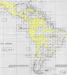
An index map of South and Central America
An index map is a finding aid for a set of maps covering regions of interest along with a name or number of the relevant map sheet. It provides geospatial data on either a sheet of paper or a computer display, like a gazetteer, with the location (such as a call number) represented within a grid overlaying the map's surface.[1]
Geospatial data is often preferred to political borders, which often change. Information is searchable by coordinates, rather than the metadata for a particular country and region that can be entered into a catalog. In various institutions, maps are cataloged individually or as sets, resulting in various levels of specificity.
References
- ↑ Jensen, K.L. (June 2004), "Index maps for the digital age", Information Technology and Libraries, 23 (2): 81–87
This article is issued from Wikipedia. The text is licensed under Creative Commons - Attribution - Sharealike. Additional terms may apply for the media files.