Menomonie, Wisconsin | |
|---|---|
City | |
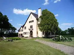
 Dunn County Government Center, Menomonie | |
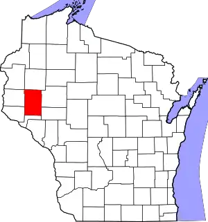
 Location of Menomonie in Dunn County, Wisconsin | |
 Menomonie Location within Wisconsin  Menomonie Location within the United States  Menomonie Menomonie (North America) | |
| Coordinates: 44°52′45″N 91°55′5″W / 44.87917°N 91.91806°W | |
| Country | United States |
| State | Wisconsin |
| County | Dunn |
| Founded by | William Wilson |
| Area | |
| • Total | 15.44 sq mi (39.98 km2) |
| • Land | 13.70 sq mi (35.47 km2) |
| • Water | 1.74 sq mi (4.51 km2) |
| Population | |
| • Total | 16,843 |
| • Estimate (2021)[3] | 16,794 |
| • Density | 1,229.9/sq mi (474.9/km2) |
| Time zone | UTC−6 (Central (CST)) |
| • Summer (DST) | UTC−5 (CDT) |
| Zip Code | 54751 |
| Area code(s) | 715 & 534 |
| FIPS code | 55-51025 |
| Website | www |
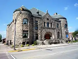
Menomonie (/məˈnɒməni/) is a city in and the county seat of Dunn County in the western part of the U.S. state of Wisconsin.[4] The city's population was 16,843 as of the 2020 census.[2]
Named for the original inhabitants of the area, the Menominee,[5] the city forms the core of the United States Census Bureau's Menomonie Micropolitan Statistical Area (MSA), which includes all of Dunn County (2010 population: 43,857). The Menomonie MSA and the Eau Claire–Chippewa Falls metropolitan area to the east form the Census Bureau's Eau Claire-Menomonie Consolidated Metropolitan Statistical Area.
The city center is at the south end of Lake Menomin, a reservoir on the Red Cedar River.
History
The earliest known residents of the area were people from the Trempealeau Hopewell Culture of the Middle Woodland Period (100–400 CE).[6] Evidence from their culture includes a mound from the Wakanda Mounds Group in Wakanda Park, along the western shore of Lake Menomin. Most of these mounds are thought to be from Effigy Mound cultures from this time period. Artifacts from the Late Woodland Period (400–1000 CE) have also been uncovered. It is theorized that agricultural villages supported the population during summer months, transitioning to hunting and gathering from fall through spring. The next known population group is the Santee Dakota in the 1600s and 1700s, who engaged in conflicts with the Ojibwe people, who migrated west as refugees. Armed with European weapons, the Ojibwe pushed westward, eventually winning at the Battle of Kathio in 1770. The two tribes continued their warfare, eventually signing the 1825 First Treaty of Prairie du Chien, which made a border between the two just north of Menomonie, with the Dakota claiming the southern lands.[7]
In 1788, French-Canadian fur trader and schoolmaster Jean Baptiste Perrault established a trading post and fort on the Red Cedar River very near Menomonie.[7][8]
The lumber industry brought Menomonie permanent settlement and economic prosperity in the 1800s. Hardin Perkins established the first sawmill at the confluence of Wilson Creek and the Red Cedar River in 1822 on behalf of fur traders James H. Lockwood and Joseph Rolette of Prairie du Chien. The mill was washed away by a sudden overflow in the river within a year. Working with Indian Agent General Street, Perkins, Lockwood and Rolette began a legal battle over the authority of the local Native American people to grant permissions of this sort, exchanging land for payment of blankets, beads, whiskey, and other merchandise to Dakota Chief Wapasha II and other Ojibwe chiefs. In 1830 the traders received permission from the federal government to rebuild their lumber operation. This was the first permanent settlement on the land that became the city of Menomonie.[7][9]
Lockwood built a second mill and dam on the west side of the Red Cedar River, at the confluence of Gilbert Creek. He sold this to Hiram S. Allen, a lumberman from Vermont. In 1839, Allen built a new sawmill in its place, which he sold to the McCann brothers, settlers from Ohio who later became the first permanent residents of Eau Claire.[10][11] In 1849, the Gilbert Creek Mill became the site of the first post office.[12]
Lockwood and Rolette sold their original operation to James Green in 1841, who turned over the deed to William Black in 1842.[12][13] In 1846, William Wilson and John Holly Knapp jointly purchased the mill, naming it Black & Knapp Mill. Wilson and his family settled in the area, eventually building what is now the Wilson Place Museum in 1859. Wilson founded the city of Menomonie and became its first mayor in 1882, as well as a Wisconsin State Senator.[14]
Captain Andrew Tainter and Henry L. Stout acquired 1⁄3 interest in Wilson and Knapp's company, forming Knapp, Stout & Co. in 1853, the company that would come to define the town for generations. Tainter was a silent partner, whose duties included shipping lumber down to the Mississippi River and returning with supplies.[15] By 1873, Knapp, Stout & Co. had become the world's largest lumber corporation. In 43 years, its output grew from 100,000 to 5,706,602 feet of lumber. It had 1,200 employees and owned 115,000 acres (47,000 ha) of pine forest.[9] The post office was moved to the site of the Knapp, Stout & Co. Company in 1855, with Wilson as postmaster.[16]
Menomonie was incorporated as a city in 1882.[17]
The Mabel Tainter Memorial Building, a local landmark, was built in 1890 and dedicated on July 3, 1890, by Tainter in honor of his daughter Mabel, who had died in 1886 at the age of 19.[7] In 1891, Wisconsin State Senator James Huff Stout, son of Henry L. Stout, founded a manual training school, the first of several educational enterprises he launched in Menomonie. These educational programs were combined into the Stout Institute in 1908, and still stand as the University of Wisconsin–Stout.[18]
In 1901, the water mill shut down and Knapp, Stout & Co. closed operations in the area. The Wisconsin Power Company and Submerged Electric Motor Co. acquired some of the company's facilities, the latter to house the world's first outboard motor factory. In 1902, the Wilson-Weber Lumber Company took over retail operations of the Knapp, Stout & Co. That same year, Menomonie founded the nation's first agricultural high school, the Dunn County School of Agriculture and Domestic Economy.[19]
Geography
Menomonie is located at 44°52′45″N 91°55′5″W / 44.87917°N 91.91806°W (44.879, −91.918).[20]
According to the United States Census Bureau, the city has an area of 15.47 square miles (40.07 km2), of which 13.69 square miles (35.46 km2) is land and 1.78 square miles (4.61 km2) is water.[21]
Menomonie is along Interstate 94, State Highway 25 (which serves as the main north–south thoroughfare through town), State Highway 29, U.S. Highway 12, and Dunn County Road B.
Climate
| Climate data for Menomonie, Wisconsin, 1991–2020 normals, extremes 1957–present | |||||||||||||
|---|---|---|---|---|---|---|---|---|---|---|---|---|---|
| Month | Jan | Feb | Mar | Apr | May | Jun | Jul | Aug | Sep | Oct | Nov | Dec | Year |
| Record high °F (°C) | 55 (13) |
60 (16) |
82 (28) |
90 (32) |
96 (36) |
98 (37) |
100 (38) |
101 (38) |
96 (36) |
90 (32) |
76 (24) |
64 (18) |
101 (38) |
| Mean maximum °F (°C) | 42.7 (5.9) |
48.4 (9.1) |
62.6 (17.0) |
77.8 (25.4) |
85.4 (29.7) |
89.9 (32.2) |
91.0 (32.8) |
90.1 (32.3) |
86.3 (30.2) |
79.3 (26.3) |
62.3 (16.8) |
47.1 (8.4) |
92.9 (33.8) |
| Mean daily maximum °F (°C) | 24.0 (−4.4) |
29.4 (−1.4) |
41.9 (5.5) |
56.4 (13.6) |
68.2 (20.1) |
77.9 (25.5) |
82.0 (27.8) |
79.9 (26.6) |
72.2 (22.3) |
58.9 (14.9) |
42.7 (5.9) |
29.2 (−1.6) |
55.2 (12.9) |
| Daily mean °F (°C) | 14.3 (−9.8) |
18.3 (−7.6) |
30.6 (−0.8) |
44.3 (6.8) |
56.3 (13.5) |
66.3 (19.1) |
70.6 (21.4) |
68.3 (20.2) |
60.2 (15.7) |
47.5 (8.6) |
33.1 (0.6) |
20.6 (−6.3) |
44.2 (6.8) |
| Mean daily minimum °F (°C) | 4.5 (−15.3) |
7.3 (−13.7) |
19.3 (−7.1) |
32.3 (0.2) |
44.4 (6.9) |
54.8 (12.7) |
59.2 (15.1) |
56.7 (13.7) |
48.2 (9.0) |
36.0 (2.2) |
23.6 (−4.7) |
12.0 (−11.1) |
33.2 (0.7) |
| Mean minimum °F (°C) | −17.8 (−27.7) |
−13.5 (−25.3) |
−1.8 (−18.8) |
18.5 (−7.5) |
30.4 (−0.9) |
41.2 (5.1) |
48.5 (9.2) |
46.4 (8.0) |
33.8 (1.0) |
22.6 (−5.2) |
7.8 (−13.4) |
−9.9 (−23.3) |
−20.2 (−29.0) |
| Record low °F (°C) | −39 (−39) |
−40 (−40) |
−34 (−37) |
4 (−16) |
20 (−7) |
30 (−1) |
41 (5) |
37 (3) |
25 (−4) |
12 (−11) |
−13 (−25) |
−36 (−38) |
−40 (−40) |
| Average precipitation inches (mm) | 0.94 (24) |
1.08 (27) |
1.97 (50) |
2.96 (75) |
4.53 (115) |
5.14 (131) |
4.02 (102) |
4.02 (102) |
3.63 (92) |
2.74 (70) |
1.82 (46) |
1.34 (34) |
34.19 (868) |
| Average snowfall inches (cm) | 9.7 (25) |
11.0 (28) |
7.3 (19) |
2.4 (6.1) |
0.0 (0.0) |
0.0 (0.0) |
0.0 (0.0) |
0.0 (0.0) |
0.0 (0.0) |
0.2 (0.51) |
3.5 (8.9) |
6.3 (16) |
40.4 (103.51) |
| Average precipitation days (≥ 0.01 in) | 8.0 | 6.3 | 8.0 | 10.5 | 12.9 | 12.6 | 10.9 | 10.4 | 10.5 | 10.3 | 7.6 | 8.5 | 116.5 |
| Average snowy days (≥ 0.1 in) | 5.4 | 4.4 | 3.0 | 1.0 | 0.1 | 0.0 | 0.0 | 0.0 | 0.0 | 0.1 | 1.8 | 5.4 | 21.2 |
| Source 1: NOAA[22] | |||||||||||||
| Source 2: National Weather Service[23] | |||||||||||||
Demographics
| Census | Pop. | Note | %± |
|---|---|---|---|
| 1880 | 2,589 | — | |
| 1890 | 5,491 | 112.1% | |
| 1900 | 5,655 | 3.0% | |
| 1910 | 5,036 | −10.9% | |
| 1920 | 5,104 | 1.4% | |
| 1930 | 5,595 | 9.6% | |
| 1940 | 6,582 | 17.6% | |
| 1950 | 8,245 | 25.3% | |
| 1960 | 8,624 | 4.6% | |
| 1970 | 11,112 | 28.8% | |
| 1980 | 12,769 | 14.9% | |
| 1990 | 13,547 | 6.1% | |
| 2000 | 14,937 | 10.3% | |
| 2010 | 16,264 | 8.9% | |
| 2020 | 16,843 | 3.6% | |
| 2021 (est.) | 16,794 | [3] | −0.3% |
| U.S. Decennial Census | |||
2020 census
As of the census[3] of 2020, there were 16,843 people. The population density was 1,229.9 inhabitants per square mile (474.9/km2). There were 6,674 housing units at an average density of 487.3 per square mile (188.1/km2). The racial makeup of the city was 88.1% White, 4.4% Asian, 1.7% Black or African American, 0.5% Native American, 0.9% from other races, and 4.5% from two or more races. Ethnically, the population was 2.8% Hispanic or Latino of any race.[2]
2010 census
As of the census[24] of 2010, there were 16,264 people, 5,743 households, and 2,455 families living in the city. The population density was 1,188.0 inhabitants per square mile (458.7/km2). There were 6,234 housing units at an average density of 455.4 per square mile (175.8/km2). The racial makeup of the city was 91.9% White, 0.8% African American, 0.5% Native American, 4.2% Asian, 0.6% from other races, and 1.9% from two or more races. Hispanic or Latino of any race were 1.7% of the population.
There were 5,743 households, of which 20.1% had children under the age of 18 living with them, 30.9% were married couples living together, 8.4% had a female householder with no husband present, 3.4% had a male householder with no wife present, and 57.3% were non-families. 36.1% of all households were made up of individuals, and 12.7% had someone living alone who was 65 years of age or older. The average household size was 2.26 and the average family size was 2.87.
The median age in the city was 23.4 years. 13.4% of residents were under the age of 18; 42% were between the ages of 18 and 24; 18.5% were from 25 to 44; 14.9% were from 45 to 64; and 11% were 65 years of age or older. The gender makeup of the city was 49.5% male and 50.5% female.
It is important to remember that a large percentage of the 42% between 18 and 24 were students at the University of Wisconsin-Stout.
2000 census
As of the 2000 census,[25] there were 14,937 people, 5,119 households, and 2,370 families living in the city. The population density was 1,160.7 people per square mile (448.1/km2). There were 5,441 housing units at an average density of 422.8 per square mile (163.2/km2). The racial makeup of the city was 93.79% White, 0.76% Black or African American, 0.41% Native American, 3.21% Asian, 0.01% Pacific Islander, 0.64% from other races, and 1.18% from two or more races. 1.14% of the population were Hispanic or Latino of any race.
There were 5,119 households, out of which 22.6% had children under the age of 18 living with them, 36.0% were married couples living together, 7.5% had a female householder with no husband present, and 53.7% were non-families. 32.7% of all households were made up of individuals, and 11.1% had someone living alone who was 65 years of age or older. The average household size was 2.35 and the average family size was 2.95.
In the city, the population was spread out, with 15.5% under the age of 18, 40.4% from 18 to 24, 20.5% from 25 to 44, 12.3% from 45 to 64, and 11.3% who were 65 years of age or older. The median age was 23 years. For every 100 females, there were 99.1 males. For every 100 females age 18 and over, there were 98.6 males.
The median income for a household in the city was $31,103, and the median income for a family was $44,458. Males had a median income of $30,893 versus $21,898 for females. The per capita income for the city was $15,994. About 9.1% of families and 23.5% of the population were below the poverty line, including 16.7% of those under age 18 and 7.3% of those age 65 or over.
Transportation
| Headquarters | 640 Stokke Parkway, Menomonie, Wisconsin |
|---|---|
| Locale | Menomonie, Wisconsin |
| Service type | Bus service, paratransit |
| Routes | 2 |
| Fleet | 9 |
| Annual ridership | 94,599 (2022)[26] |
| Website | www |
Dunn County Transit
Dunn County Transit is Menomonie's public transportation system. It is owned and operated by Dunn County.
Services
The transit system operates two routes. The Community Route serves Menomonie at large; the Stout Route serves only UW-Stout but is open to the general public. These routes run as follows:[27]
- Community Route: 7:37am – 4:09pm Monday through Friday and 8:53am – 12:09pm on Saturdays
- Stout Route: 7:17am – 9:09pm Monday through Friday
Ridership
| Ridership | Change over previous year | |
|---|---|---|
| 2014[28] | 159,088 | n/a |
| 2015[29] | 153,606 | |
| 2016[30] | 133,776 | |
| 2017[31] | 111,208 | |
| 2018[32] | 114,652 | |
| 2019[33] | 135,194 | |
| 2020[34] | 98,821 | |
| 2021[35] | 29,697 | |
| 2022[26] | 94,599 | |
Menomonie Municipal Airport (KLUM) serves the city and surrounding communities.
Education

Menomonie schools are part of the Menomonie Area School District.
The city has one public high school, Menomonie High School, and one public middle school, Menomonie Middle School. There are five public elementary schools in the district: River Heights Elementary, Wakanda Elementary, Oaklawn Elementary], Downsville Elementary, and Knapp Elementary.
St. Paul's Lutheran School is a Christian Pre-K–8 school of the Wisconsin Evangelical Lutheran Synod (WELS) in Menomonie.[36]
The city is home to the University of Wisconsin–Stout and a campus of Chippewa Valley Technical College.
Jail
Dunn County Jail is on Menomonie's eastern edge. It houses sentenced and non-sentenced, male and female inmates. As of July 2020, there are just over 80 inmates.[37]
Media
- The Menomonie Times, a weekly newspaper published 1876–1909, LCCN sn86-86695
- The Menomonie Badger, a weekly newspaper published in 1903 and 1904[38]
- The Dunn County News
Honors
In 2012, Menomonie was ranked #15 in Smithsonian's "The 20 Best Small Towns in America".[39]
Notable people
- Stewart J. Bailey, Wisconsin legislator[40]
- Bill Bakke, ski jumper who competed in the 1968 Winter Olympics[41]
- G. H. Bakke, Wisconsin legislator[42]
- Alvin J. Baldus, U.S. Representative[43]
- Wilfred Duford, NFL player[44]
- Rockwell J. Flint, Wisconsin state legislator and newspaper editor[45]
- Vern Fuller, MLB player[46]
- Neil Gaiman, writer and screenwriter, has lived near Menomonie since 1992[47]
- John Paul Gerber, author and historian[48]
- Wilson Hall, half of the comedy duo God's Pottery
- Tim Harmston, stand-up comedian[49]
- Lorenzo D. Harvey, educator[50]
- Luke Helder, University of Wisconsin—Stout student who attempted to create a smiley-face on the US map with pipe bombs[51]
- Ethan Iverson, jazz pianist and founding member of The Bad Plus
- Warren S. Johnson, founder of Johnson Controls and former school principal in Menomonie[52] in the late 19th century
- Ellen Kort, Wisconsin's first Poet Laureate,[53] grew up in Menomonie[54]
- Reynold Kraft, NFL player[55]
- Tim Krumrie, Pro Bowl (1987–1988), nose tackle for the Cincinnati Bengals
- Robert Macauley, Wisconsin legislator and jurist[56]
- Harry Miller, "the greatest creative figure in the history of the American racing car"[57]
- Tom Neumann, professional football player[58]
- Marvin Panch, stock car racing driver, winner of 1961 Daytona 500
- Sewell A. Peterson, politician
- Joe Plouff, politician
- Charles Sanna, inventor of Swiss Miss instant hot chocolate[59]
- Richard Shoemaker, Wisconsin legislator[60]
- Nate Stanley, NFL player
- Earl L. Stendahl, art dealer
- James Huff Stout, legislator and businessman[61]
- Jeremiah Burnham Tainter, engineer[62]
- Tom Wiedenbauer, Major League Baseball outfielder and first-base coach for the Cleveland Indians
- Aaron Yonda, comedy video producer[63]
Notable attractions
- The Mabel Tainter Theater[64]
- Hoffman Hills State Recreation Area[65]
- Lucette Brewing Company[66]
- Red Cedar State Trail[67]
In popular culture
- Caddie Woodlawn, a Newbery Award-winning novel, is based on the girlhood adventures of Caroline Augusta Woodhouse, who lived about 10 miles south of Menomonie. The novel is by Woodhouse's granddaughter, Carol Ryrie Brink, and was published in 1936. There is a historical marker in the wayside park near the Woodhouse house.[68]
- The fictional town of Lakeside in Neil Gaiman's novel American Gods may be based on Menomonie.[69]
- The eighth episode of season 11 of the television show Supernatural takes place in Menomonie.[70]
- Holloway Roberts from Mark Z. Danielewski's House of Leaves was born in Menomonie. He uses this fact as a mantra throughout his narrative.
Sister cities
Menomonie has two sister city relationships:[71]
 Nasukarasuyama, Japan
 Konakovo, Russia
See also
References
- ↑ "2019 U.S. Gazetteer Files". United States Census Bureau. Retrieved August 7, 2020.
- 1 2 3 "2020 Decennial Census: Menomonie city, Wisconsin". data.census.gov. U.S. Census Bureau. Retrieved July 6, 2022.
- 1 2 3 "US Census Bureau".
- ↑ "Find a County". National Association of Counties. Retrieved June 7, 2011.
- ↑ A History of the Origin of the Place Names Connected with the Chicago & North Western and Chicago, St. Paul, Minneapolis & Omaha Railways. Chicago and North Western Railway Company. 1908. p. 160 – via Google Books.
- ↑ "Archaeology in Trempealeau, Wisconsin". Mississippi Valley Archaeology Center. Archived from the original on December 31, 2020. Retrieved December 31, 2020.
- 1 2 3 4 "A Menomonie Timeline". Dunn History. Archived from the original on March 27, 2019. Retrieved October 31, 2016.
- ↑ Cormier, Louis-Philippe (2003). "Perrault, Jean-Baptiste". Dictionary of Canadian Biography. Vol. 7. University of Toronto/Université Laval. Retrieved October 31, 2016.
- 1 2 "The History of Menomonie". Menomonie.com. Archived from the original on March 24, 2015. Retrieved October 31, 2016.
- ↑ "A Menomonie Timeline: 1830s". Dunn History. Retrieved October 31, 2016.
- ↑ Bailey, W. F. (1914). History of Eau Claire county, Wisconsin, past and present; including an account of the cities, towns and villages of the county. Chicago: C. F. Cooper.
- 1 2 "A Menomonie Timeline: 1840s". Dunn History. Retrieved October 31, 2016.
- ↑ Curtiss-Wedge, F.; Jones, Geo. O., eds. (1925). "Chapter X: The Knapp Stout & Co. company". History of Dunn County, Wisconsin. H.C. Cooper, Jr. & Co. p. 62. Retrieved October 31, 2016 – via The State of Wisconsin Collection.
- ↑ "The Wilson Place". Dunn History. Retrieved October 31, 2016.
- ↑ "Tainter, Andrew, Capt. (b.1823), Chippewa County, Wisconsin Biographical Records". WI Clark County History.org. Retrieved October 31, 2016.
- ↑ "A Menomonie Timeline: 1850s". Dunn History. Retrieved October 31, 2016.
- ↑ "A Menomonie Timeline: 1880s". Dunn History. Retrieved October 31, 2016.
- ↑ "What's in a Name?". University of Wisconsin–Stout. Archived from the original on April 13, 2012. Retrieved October 31, 2016.
- ↑ "A Menomonie Timeline: 1900s". Dunn History. Archived from the original on October 8, 2020. Retrieved October 31, 2016.
- ↑ "US Gazetteer files: 2010, 2000, and 1990". United States Census Bureau. February 12, 2011. Retrieved April 23, 2011.
- ↑ "US Gazetteer files 2010". United States Census Bureau. Archived from the original on January 25, 2012. Retrieved November 18, 2012.
- ↑ "U.S. Climate Normals Quick Access – Station: Menomonie, WI". National Oceanic and Atmospheric Administration. Retrieved March 8, 2023.
- ↑ "NOAA Online Weather Data – NWS Minneapolis". National Weather Service. Retrieved March 8, 2023.
- ↑ "U.S. Census website". United States Census Bureau. Retrieved November 18, 2012.
- ↑ "U.S. Census website". United States Census Bureau. Retrieved January 31, 2008.
- 1 2 "2022 Annual Agency Profile" (PDF). Federal Transit Administration. Dunn County Transit Commission.
- ↑ "Community Route" (PDF). Dunn County, Wisconsin. Dunn County Transit Commission. June 1, 2021.
- ↑ "2014 Annual Agency Profile" (PDF). Federal Transit Administration. Dunn County Transit Commission.
- ↑ "2015 Annual Agency Profile" (PDF). Federal Transit Administration. Dunn County Transit Commission.
- ↑ "2016 Annual Agency Profile" (PDF). Federal Transit Administration. Dunn County Transit Commission.
- ↑ "2017 Annual Agency Profile" (PDF). Federal Transit Administration. Dunn County Transit Commission.
- ↑ "2018 Annual Agency Profile" (PDF). Federal Transit Administration. Dunn County Transit Commission.
- ↑ "2019 Annual Agency Profile" (PDF). Federal Transit Administration. Dunn County Transit Commission.
- ↑ "2020 Annual Agency Profile" (PDF). Federal Transit Administration. Dunn County Transit Commission.
- ↑ "2021 Annual Agency Profile" (PDF). Federal Transit Administration. Dunn County Transit Commission.
- ↑ "St. Paul's Christian Day School".
- ↑ "Dunn County Jail". Dunn County. Retrieved July 27, 2020.
- ↑ "About The Menomonie Badger (Menomonie, Wis.) 1903-1904". Chronicling America. Library of Congress. Retrieved December 26, 2013.
- ↑ Spano, Susan; Shen, Aviva (April 30, 2012). "The 20 Best Small Towns in America of 2012". Smithsonian Magazine. Retrieved October 31, 2016.
- ↑ The Blue Book of the State of Wisconsin. 1889. p. 506.
- ↑ Evans, Hilary; Gjerde, Arild; Heijmans, Jeroen; Mallon, Bill; et al. "Menomonie, Wisconsin". Olympics at Sports-Reference.com. Sports Reference LLC. Archived from the original on April 18, 2020. Retrieved May 23, 2013.
- ↑ Toepel, M. G.; Kuehn, Hazel L., eds. (1952). "Members of the Legislature". The Wisconsin Blue Book. Retrieved October 31, 2016 – via The State of Wisconsin Collection.
- ↑ Kestenbaum, Lawrence. "The Political Graveyard: Index to Politicians: Bakerhine to Baldus". Political Graveyard.com. Retrieved October 31, 2016.
- ↑ "Dukes Duford Stats". Pro-Football-Reference.com. Retrieved October 31, 2016.
- ↑ "Biographical Sketch of Rockwell J. Flint". Wisconsin Blue Book. 1882. p. 537.
- ↑ "Vern Fuller Statistics and History". Baseball-Reference.com. Retrieved October 31, 2016.
- ↑ "Neil Gaiman". IMDb.com. Retrieved October 31, 2016.
- ↑ "John Gerber (obituary)", Boston Globe, July 8, 2010, retrieved May 29, 2011
- ↑ Anderson, Deb (November 25, 2009). "Comedy rocks Mabel Tainter". Chippewa Herald. Chippewa Falls, Wisconsin. Retrieved April 28, 2020.
- ↑ Kestenbaum, Lawrence. "The Political Graveyard: Index to Politicians: Harvey". Political Graveyard.com. Retrieved October 31, 2016.
- ↑ "Federal charges brought against accused mailbox bomber". CNN.com. May 10, 2002. Archived from the original on September 8, 2008. Retrieved October 31, 2016.
- ↑ "Warren S. Johnson". Wisconsin Historical Society. Retrieved October 31, 2016.
- ↑ "Ellen Kort | Wisconsin Poet Laureate Commission".
- ↑ "Ellen Kort Obituary (2015) Appleton Post-Crescent". Legacy.com. April 21, 2015.
- ↑ "Reynold Kraft Stats". Pro-Football-Reference.com. Retrieved October 31, 2016.
- ↑ "Biographical Sketch of Robert Macauley". Proceedings of the State Bar Association of Wisconsin. Wisconsin Bar Association. 1907. pp. 297–298.
- ↑ "Harry Miller, Automotive Genius". discover-net.net. Archived from the original on August 6, 2012. Retrieved October 31, 2016.
- ↑ "Tom Neumann Stats". Pro-Football-Reference.com. Retrieved October 31, 2016.
- ↑ Roberts, Sam (April 2, 2019). "Charles Sanna, Man Behind Swiss Miss Cocoa, Dies at 101". The New York Times. Retrieved April 12, 2019.
- ↑ "Biographical Sketch of Richard Shoemaker". Wisconsin Blue Book. 1989–1990. p. 40.
- ↑ "A Short Biography: James Huff Stout". University of Wisconsin-Stout. Archived from the original on September 29, 2011. Retrieved October 31, 2016.
- ↑ "The Tainter Gate". Dunn History. Retrieved October 31, 2016.
- ↑ "Improv Shows & Classes in Madison, WI". Monkey Business Institute. Retrieved October 31, 2016.
- ↑ "| Menomonie's Historic Theater ideal for entertainment, weddings, business meetings and tours". Retrieved August 29, 2019.
- ↑ "Hoffman Hills State Recreation Area | Travel Wisconsin". TravelWisconsin. Retrieved August 29, 2019.
- ↑ "Lucette Brewing Company, Menomonie - Restaurant Reviews, Photos & Phone Number". TripAdvisor. Retrieved August 29, 2019.
- ↑ "Red Cedar State Trail (Menomonie) - 2019 All You Need to Know BEFORE You Go (with Photos)". TripAdvisor. Retrieved August 29, 2019.
- ↑ "Caddie Woodlawn". Historical Marker Project. Retrieved October 31, 2016.
- ↑ "American Gods Roadtrip". Arteries of America. July 4, 2011. Retrieved February 17, 2021.
- ↑ "11.08 Just My Imagination - Super-wiki". www.supernaturalwiki.com. Retrieved February 17, 2021.
- ↑ "Menomonie's Japanese sister city affected by earthquake". Chippewa Herald. April 20, 2011. Retrieved September 6, 2020.
Further reading
- Shaw, Adele Marie (1904). "The Ideal Schools of Menomonie". The World's Work.
