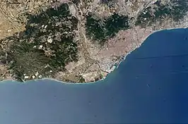
- Àmbit metropolità de Barcelona

Àmbit metropolità de Barcelona (Catalan pronunciation: [ˈambid mətɾupuliˈta ðə βəɾsəˈlonə]), also known as the vegueria of Barcelona,[1] is one of the eight regions (vegueries) defined by the Regional Plan of Catalonia. It is located in the Centre of the Pre-Coastal Range. It is the most populated region, with 4,916,847 inhabitants as of 2022,[2] and its area is 2,464.4 km².
The region includes the comarques of Baix Llobregat, Barcelonès, Maresme, Vallès Occidental and Vallès Oriental. Within Catalonia, it borders to the south with Camp de Tarragona, to the west with Central Catalonia and the north with the vegueria of Girona. Its capital city is Barcelona.
Characteristics
The region was defined in 1987 in the Territorial Planning Laws approved by the Parliament of Catalonia.[3] It currently comprises the comarques of Baix Llobregat, Barcelonès, Maresme, Vallès Occidental and Vallès Oriental, that is, Barcelona and its area of economic and market influence. Alt Penedès and Garraf were initially part of it as well, but were integrated into the new area of Penedès in 2017.
In April 2008, the Department of Territorial Policy and Public Works of the Generalitat de Catalunya presented the preliminary draft of the Barcelona Metropolitan Territorial Plan, which delimits the areas of scenic and strategic interest that are to be preserved and aims to promote a quality road and rail network.[4]
Demography
The region's most populated cities (100,000+ inhabitants) are Barcelona, L'Hospitalet de Llobregat, Badalona, Terrassa, Sabadell, Mataró and Santa Coloma de Gramenet.
Population by comarca
| Comarques | Population
(2022)[5] |
|---|---|
| Barcelonès | 2,268,056 |
| Baix Llobregat | 828,889 |
| Maresme | 457,583 |
| Vallès Occidental | 940,969 |
| Vallès Oriental | 417,265 |
See also
References
- ↑ "Document". Portal Jurídic de Catalunya (in Catalan). Retrieved 2023-07-09.
- ↑ "Idescat. Statistical Yearbook of Catalonia. Population on 1 January. Counties and Aran, areas and provinces". www.idescat.cat. Retrieved 2023-07-09.
- ↑ "Wayback Machine". 2009-06-08. Archived from the original on 2009-06-08. Retrieved 2023-07-09.
- ↑ "PTMB". www.collserola.org. Retrieved 2023-07-09.
- ↑ "Idescat. Anuari estadístic de Catalunya. Població a 1 de gener. Comarques i Aran, àmbits i províncies". www.idescat.cat. Retrieved 2023-06-29.