Mezitli | |
|---|---|
District and municipality | |
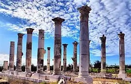
 Colonnades of ancient Soli Pompeipolis | |
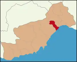
 Map showing Mezitli District in Mersin Province | |
 Mezitli Location in Turkey | |
| Coordinates: 36°45′N 34°32′E / 36.750°N 34.533°E | |
| Country | Turkey |
| Province | Mersin |
| Government | |
| • Mayor | Neşet Tarhan (CHP) |
| Area | 371 km2 (143 sq mi) |
| Population (2022)[1] | 222,436 |
| • Density | 600/km2 (1,600/sq mi) |
| Time zone | TRT (UTC+3) |
| Area code | 0324 |
| Website | www |
Mezitli is a municipality and district of Mersin Province, Turkey.[2] Its area is 371 km2,[3] and its population is 222,436 (2022).[1] It covers the westernmost part of the city of Mersin and the adjacent countryside. The Mayor of Mezitli is Neşet Tarhan.[4]
Geography
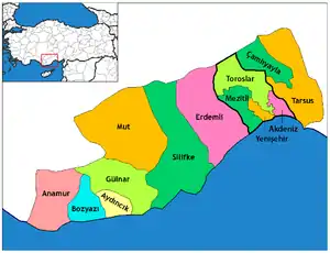
Mezitli covers the western part of Mersin proper. Southern quarters of Mezitli are popularly known as Viranşehir ("ruined city") because of the ruins. (see below) Yenişehir, another municipality of Mersin, is to the east of Mezitli, Mediterranean Sea is in the south and Toros Mountains in the north.[5] In the west of Mezitli there are summer houses and coastal villages most of which are specialized in citrus industry. Mezitli River (Liparis of the antiquity) flows within Mezitli.
History
The ruins of the ancient Greek city of Soli, which was renamed by Roman general Pompey as Pompeipolis (Πομπηιόπολη) is within Mezitli. Soli was the dominion of Rhodes, Persian Empire (Achaemenids), Macedonian Empire, Seleucid Empire, Roman Empire and its successor Byzantine Empire. But after the great earthquake in 528, the city lost its former glory. In later years, the ruins of the city was a part of Umayyad Caliphate, Seljuk Sultanate of Rum, Crusades, Armenian Kingdom of Cilicia, Ramadanids, and Ottoman Empire. In the early 20th century, there was only a small village just north of Soli, named after "Mezitoğlu", an Oghuz tribe.
The town municipality was established in 1968. In 2008 the district Mezitli was created from part of the former central district of Mersin, along with the districts Akdeniz, Toroslar and Yenişehir. At the same time, the former municipalities Davultepe, Tece and Kuyuluk were absorbed into the municipality of Mezitli.[6][7] At the 2013 Turkish local government reorganisation, the rural part of the district was integrated into the municipality, the villages becoming neighbourhoods.[8]
Living
Mezitli is known as a district of middle class residences. Most of Mezitli citizens are either retired or active working people. (Most of business offices are in the other municipalities of Mersin.)
Composition
There are 40 neighbourhoods in Mezitli District:[9]
- 75. Yıl
- Akarca
- Akdeniz
- Anayurt
- Atatürk
- Bozön
- Çamlıca
- Çankaya
- Cemilli
- Çevlik
- Cumhuriyet
- Davultepe
- Demirışık
- Deniz
- Doğançay
- Doğlu
- Esenbağlar
- Eski Mezitli
- Fatih
- Fındıkpınarı
- Hürriyet
- İstiklal
- Kaleköy
- Kocayer
- Kuyuluk
- Kuzucu
- Kuzucubelen
- Menderes
- Merkez
- Pelitkoyağı
- Şahintepesi
- Sarılar
- Seymenli
- Takanlı
- Tece
- Tepeköy
- Tol
- Viranşehir
- Yenimahalle
- Zeybekler
International relations
Mezitli is twinned with:
 Tempelhof-Schöneberg borough of Berlin, Germany
 Çatalköy, Northern Cyprus
References and notes
- 1 2 "Address-based population registration system (ADNKS) results dated 31 December 2022, Favorite Reports" (XLS). TÜİK. Retrieved 12 July 2023.
- ↑ Büyükşehir İlçe Belediyesi, Turkey Civil Administration Departments Inventory. Retrieved 12 July 2023.
- ↑ "İl ve İlçe Yüz ölçümleri". General Directorate of Mapping. Retrieved 12 July 2023.
- ↑ Gazetee, Banka (21 November 2021). "Mezitli Belediyesinde toplu sözleşme sevinci". Gazete Banka. p. https://gazetebanka.com/. Retrieved 21 November 2021.
- ↑ "Mezitli Belediyemizin Tarihçesi - ::: MEZİTLİ BELEDİYESİ RESMİ WEB PORTALI :::". Archived from the original on 2009-07-17. Retrieved 2009-09-23.
- ↑ Kanun No. 5747, Resmî Gazete, 22 March 2008.
- ↑ "İl İdaresi ve Mülki Bölümler Şube Müdürlüğü İstatistikleri - İl ve İlçe Kuruluş Tarihleri" (PDF) (in Turkish). p. 63. Retrieved 5 September 2023.
- ↑ "Law No. 6360". Official Gazette (in Turkish). 6 December 2012.
- ↑ Mahalle, Turkey Civil Administration Departments Inventory. Retrieved 12 July 2023.
