Nagan Raya Regency
Kabupaten Nagan Raya | |
|---|---|
 Seal | |
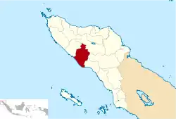 Location within Aceh | |
| Coordinates: 4°10′N 96°30′E / 4.167°N 96.500°E | |
| Country | |
| Region | Sumatra |
| Province | |
| Established | 2002 |
| Regency seat | Suka Makmue |
| Government | |
| • Regent | Muhammad Jamin Idham |
| • Vice Regent | Chalidin Oesman |
| Area | |
| • Total | 3,363.72 km2 (1,298.74 sq mi) |
| Population (mid 2022 estimate)[1] | |
| • Total | 173,393 |
| • Density | 52/km2 (130/sq mi) |
| Time zone | UTC+7 (IWST) |
| Area code | (+62) 655 |
| Website | naganrayakab.go.id |


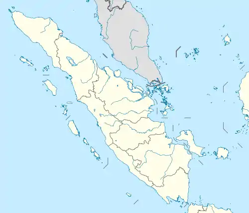
Nagan Raya Regency (Indonesian: Kabupaten Nagan Raya) is a regency in the Aceh special region of Indonesia. It is located on the island of Sumatra. The seat of the regency government is at Suka Makmue. The regency covers an area of 3,524.00 square kilometres and had a population of 139,663 people according to the 2010 Census[2] and 168,392 at the 2020 Census.[3] The official estimate as at mid 2022 was 173,393.[1]
Administrative districts
As at 2010, the regency was divided administratively into eight districts (kecamatan); however in 2011 two additional districts were created - Tripa Makmur (by division from Darul Makmur District) and Beutong Ateuh Banggalang (by division from Beutong District). Their areas (in km2) and their populations at the 2010 Census[2] and 2020 Census,[3] together with the official estimates as at mid 2022,[1] are listed below. The table also includes the locations of the district administrative centres, the number of villages (gampong) in each district, and its postal codes.
| Kode Wilayah | Name of District (kecamatan) | Area in km2 | Pop'n Census 2010 | Pop'n Census 2020 | Pop'n Estimate mid 2022 | Admin centre | No. of villages | Post codes |
|---|---|---|---|---|---|---|---|---|
| 11.15.05 | Darul Makmur | 1,021.85 | 46,954 | 49,412 | 51,336 | Alue Bilie | 40 | 23662 |
| 11.15.09 | Tripa Makmur | 188.3 | (a) | 9,038 | 9,208 | Kabu | 11 | 23663 |
| 11.15.01 | Kuala | 120.18 | 18,540 | 22,350 | 23,004 | Ujong Fatihah | 17 | 23661 |
| 11.15.07 | Kuala Pesisir (Coastal Kuala) | 75.90 | 14,110 | 17,338 | 17,912 | Padang Rubek | 16 | 23660 |
| 11.15.08 | Tadu Raya | 345.15 | 11,185 | 14,731 | 15,424 | Alue Bata | 22 | 23664 |
| 11.15.04 | Beutong | 1,011.31 | 14,228 | 13,701 | 13,837 | Keude Seumot | 24 | 23672 |
| 11.15.10 | Beutong Ateuh Banggalang | 403.53 | (b) | 1,990 | 2,039 | Kuta Teungoh | 4 | 23673 |
| 11.15.02 | Seunagan | 56.39 | 14,464 | 15,924 | 16,105 | Jeuram | 35 | 23671 |
| 11.15.06 | Suka Makmue | 51.26 | 8,022 | 9,931 | 10,274 | Lueng Baro | 19 | 23674 |
| 11.15.03 | Seunagan Timur (East Seunagan) | 250.12 | 12,160 | 13,977 | 14,254 | Keude Linteung | 34 | 23670 |
| Totals | 3,524.00 | 139,663 | 168,392 | 173,393 | Suka Makmue | 222 |
Notes: (a) included in 2010 figure for Darul Makmur District. (b) included in 2010 figure for Beutong District.
Paddy fields
In 2012, Nagan Raya Regency has 24,698 hectares paddy fields with production of 164,586 tonnes of rice equivalent per year. Only a third of production is for regency's consumption and the rest is about 110,000 tonnes sold to other regencies and even to Medan, North Sumatra Province.[4]
See also
References
- 1 2 3 Badan Pusat Statistik, Jakarta, 2023, Kabupaten Nagan Raya Dalam Angka 2023 (Katalog-BPS 1102001.1115)
- 1 2 Biro Pusat Statistik, Jakarta, 2011.
- 1 2 Badan Pusat Statistik, Jakarta, 2021.
- ↑ "Nagan Raya fokus ke pertanian". July 26, 2012. Archived from the original on March 3, 2016. Retrieved July 26, 2012.
External links
Regencies and cities of Aceh | ||
|---|---|---|
Capital: Banda Aceh | ||
| Regencies |  | |
| Cities | ||