Narsingdi
নরসিংদী | |
|---|---|
 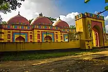 .jpg.webp) 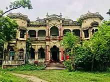  .jpg.webp) Clockwise from top-left: Skyline of Narsingdi, Parulia Shahi Mosque, Bridge at Narsingdi, Wari-Bateshwar ruins, Swamp in Raipura Upazila, Lakkan Sahar Zamindar bari | |
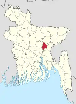 Location of Narsingdi District in Bangladesh | |
Expandable map of Narsingdi District | |
| Coordinates: 23°55′N 90°44′E / 23.92°N 90.73°E | |
| Country | |
| Division | Dhaka Division |
| Government | |
| • Deputy Commissioner | Syeda Farhana Kawnine |
| Area | |
| • Total | 1,150.14 km2 (444.07 sq mi) |
| Population (2022 census)[1] | |
| • Total | 2,584,452 |
| • Density | 2,200/km2 (5,800/sq mi) |
| Time zone | UTC+06:00 (BST) |
| Postal code | 1600 |
| Website | narsingdi |
Narsingdi District (Bengali: নরসিংদী জেলা) is a district in central Bangladesh. It is located 50 km north-east of Dhaka, capital city of Bangladesh. It is a part of the Dhaka Division.[2] The district is famous for its textile craft industry. Narsingdi is bordered by Kishoreganj in the north and north-east, Brahmanbaria in the east and south-east, Narayanganj in the south and south-west and Gazipur in the west.
Subdivisions
There are six upazilas, or subdivisions, in the Narsingdi district.
Sightseeing
Economy
Narsingdi is a densely industrial area and is home to many textile mills. Narsingdi gas field is located in the Shibpur upazila under Narsingdi district adjacent to the Dhaka-Sylhet highway about 45 km away of northern most east direction from capital city of Bangladesh, Dhaka. This field was discovered by Petrobangla in 1990. Total recoverable gas reserves of this field re-estimated by Hydrocarbon Unit is 215 billion cubic feet (6.1×10⁹ m3). Commercial gas production was started in 1996 and until 31 August 2006 total 66.304 billion cubic feet (1.8775×10⁹ m3) or 30.84 percent of gas reserves has been recovered. Largest powerplant of Bangladesh, Ghorashal power plant, owned by Bangladesh Power Development Board (PDB) is situated in palash Upazilla. Narsingdi is riched by several number of jute mills, which plays an important role in the economy. Quality banana is also found here. The biggest and renowned HAAT (textile market) of Bangladesh is located here at Madhabdi which is known as Shekherchaur / Babur Haat. Sugarcane also grows well. There is a sugar mill in Palash Thana named Deshbondho sugar mill. There are two urea fertilizer industries in Palash and Ghorashal.-->
Demographics
| Year | Pop. | ±% p.a. |
|---|---|---|
| 1974 | 1,101,154 | — |
| 1981 | 1,328,117 | +2.71% |
| 1991 | 1,652,123 | +2.21% |
| 2001 | 1,895,984 | +1.39% |
| 2011 | 2,224,944 | +1.61% |
| 2022 | 2,584,452 | +1.37% |
| Sources:[1][5] | ||
According to the 2022 Census of Bangladesh, Narsingdi District had 621,514 households and a population of 2,584,452, 24.9% of whom lived in urban areas. The population density was 2,247 people per km2. The literacy rate (age 7 and over) was 74.7%, compared to the national average of 74.7%.[1]
| Religion | Population (1941)[6]: 96–97 | Percentage (1941) | Population (2011)[5] | Percentage (2011) |
|---|---|---|---|---|
| Islam |
555,975 | 84.84% | 2,098,829 | 94.33% |
| Hinduism |
99,197 | 15.14% | 125,769 | 5.65% |
| Others [lower-alpha 2] | 128 | 0.02% | 346 | 0.02% |
| Total Population | 655,300 | 100% | 2,224,944 | 100% |
Muslims make up 94.33% of the population, while Hindus are 5.65% of the population.[5]
Rivers
The Meghna, the Shitalakshya, the old Brahmaputra, Arial Kha, Haridhoa, and Paharea are some of the main rivers that flow through this district.
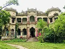
Gallery
.jpg.webp)
.jpg.webp)
.jpg.webp)
.jpg.webp)
.jpg.webp)
See also
Notes
- ↑ Narsingdi, Raipura, Shibpur, and Monohardi thanas of Dhaka district
- ↑ Including Jainism, Christianity, Buddhism, Zoroastrianism, Judaism, Ad-Dharmis, or not stated
References
- 1 2 3 Population and Housing Census 2022: Preliminary Report. Bangladesh Bureau of Statistics. August 2022. pp. viii, 29, 38, 45. ISBN 978-984-35-2977-0.
- ↑ Md. Mosharraf Hossain Sarkar (2012). "Narsingdi District". In Sirajul Islam and Ahmed A. Jamal (ed.). Banglapedia: National Encyclopedia of Bangladesh (Second ed.). Asiatic Society of Bangladesh.
- ↑ ঈদে ড্রিম হলিডে পার্কে দর্শনার্থীদের উপচেপড়া ভিড় (in Bengali).
- ↑ "Top 10 Best Resorts in Bangladesh".
- 1 2 3 4 "Bangladesh Population and Housing Census 2011 Zila Report – Narsingdi" (PDF). bbs.gov.bd. Bangladesh Bureau of Statistics.
- ↑ "Census of India, 1941 Volume VI Bengal Province" (PDF).
External links
Capital: Narsingdi | ||
| Upazilas | ||
| Constituencies | ||
| History |
| |
| Sites and attractions | ||
| Inhabited areas | ||
| Education | ||
| Rivers |
| |
| Transport |
| |
| See also | ||