National Harbor | |
|---|---|
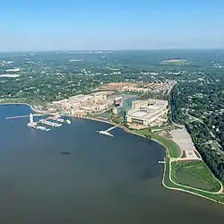 National Harbor in September 2021 | |
 National Harbor Location of National Harbor in Maryland  National Harbor National Harbor (the United States) | |
| Coordinates: 38°47′03″N 77°00′59″W / 38.78417°N 77.01639°W | |
| Country | |
| State | |
| County | |
| Unincorporated area | Oxon Hill |
| Area | |
| • Total | 1.67 sq mi (4.32 km2) |
| • Land | 1.27 sq mi (3.30 km2) |
| • Water | 0.40 sq mi (1.02 km2) |
| Population (2020) | |
| • Total | 5,509 |
| • Density | 4,327.57/sq mi (1,671.28/km2) |
| Time zone | UTC−5 (Eastern (EST)) |
| • Summer (DST) | UTC−4 (EDT) |
| ZIP Code | 20745 |
| Area code(s) | 301, 240 |
| FIPS code | 24-55018 |
| GNIS ID locale/CDP | 2426650/2583665 |
| Website | Official website |
National Harbor is a census-designated place (CDP) in Prince George's County, Maryland, United States, located along the Potomac River near the Woodrow Wilson Bridge and just south of Washington, D.C. It originated as a 300-acre (1.2 km2) multi-use waterfront development. Per the 2020 census, the population was 5,509.[3]
National Harbor is one of the most visited destinations in the United States, with over 28 million visitors annually.[4]
History
Land use and rezoning
The land developed for National Harbor was previously Salubria Plantation,[5] built in 1827 by Dr. John H. Bayne. The plantation house burned down in 1981 and was offered for sale along with the surrounding land. The land was sold in 1984 and in 1994 was rezoned for mixed-use development. In the fall of 1997, the Maryland Department of the Environment and the Army Corps of Engineers approved new developer permits, granted for the PortAmerica project in 1988.[6]
This development has caused considerable controversy due to its environmental impacts. The Sierra Club voiced strong objections in 1999 saying that construction of National Harbor would "prevent forever the completion of the Potomac Heritage Trail".[7] The site was linked to hundreds of thousands of gallons of untreated sewage being discharged into the Potomac River in 2008.[8] In 2006, Peterson Companies withdrew plans to build a Target department store where the remaining plantation building, the slave quarters, still stand.[5]
Development

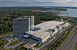
The Gaylord National Resort & Convention Center at National Harbor opened on April 1, 2008[9] in Oxon Hill, Maryland.[10] The site was developed by Milton Peterson's Peterson Companies with the project expected to cost well over $2 billion,[11] and a construction time frame of 2007 to late 2014. As of April 2016 construction was continuing and the cost was set at $4 billion.[12] In 2010, the development was designated as a census-designated place.[1]
The Walt Disney Company had announced that it would build a new resort hotel at National Harbor, but backed out of the project in November 2011.[13] In 2011, Bonnie Bick, a member of the Campaign to Reinvest in the Heart of Oxon Hill suggested preserving the remaining plantation building, and making it a part of a proposed historical loop of the Potomac Heritage National Scenic Trail, as a draw for the development.[5]
A location for the National Children's Museum opened in December 2012. The museum permanently closed in early January 2015, after having announced that it would relocate back to Washington, D.C.[14] The museum's location is now a Local Motors facility.
On November 29, 2012, ground was broken for a Tanger Outlets shopping facility a mile east of the National Harbor waterfront, which opened in November 2013.[15] The Capital Wheel (ferris wheel) opened in the mid-year of 2014.[16]
An MGM-branded casino, called MGM National Harbor, opened at National Harbor on December 8, 2016, following voters' approval of an expansion to the state's gambling program in the November 2012 elections.[17] It was built on the south side of the Beltway, about a mile northeast of the National Harbor waterfront.
On January 12, 2015, Peterson Companies announced Local Motors planned to open a location in National Harbor.[18] On June 17, 2016, Local Motors opened their facility to the public and debuted a new vehicle named Olli.[19] The facility includes a showroom of the company's latest vehicles, interactive STEM labs for children, and retail merchandise mostly featuring the company's brand.
On October 21, 2023, Titanic: The Exibhition, a museum in National Harbor, was open to the public. It features sculptures, models, and artifacts from the RMS Titanic, which sank on April 14, 1912.[20]
Facilities


The site has a convention center, six hotels, restaurants, shops, and condominiums.[16] National Harbor hosted Cirque du Soleil in 2008, 2010, 2012, and 2014 and also features outdoor activities such as a culinary festival and outdoor concerts by military bands, an outdoor movie screen facing the river, an annual ice sculpture exhibition, and a Peeps Day with a Peeps eating contest. The national spelling bee competition is held there. The Gaylord National Resort & Convention Center, with 2,000 rooms, is the largest hotel between New Jersey and Florida, and the largest in the Washington area. The site includes a beachfront walking path and a connection to a bike trail on the Woodrow Wilson Bridge that crosses into Alexandria, Virginia.[21][22] Amusements include a children's carousel, and the Capital Wheel,[16] a 175-foot Ferris wheel on a pier that extends into the Potomac River. There is a fast food restaurant and a gas station among the northern ramps that provide the only ways in or out of National Harbor.
In December 2016, MGM Resorts opened MGM National Harbor, a 300-room hotel as wel as a 135,000-square-foot (12,500 m2) casino, stores, a spa, restaurants, a 1,200-seat theater, a 35,000-square-foot (3,300 m2) convention area, and a 5,000-square-foot (460 m2) parking garage.[23]
Demographics
| Census | Pop. | Note | %± |
|---|---|---|---|
| 2010 | 3,788 | — | |
| 2020 | 5,509 | 45.4% | |
| U.S. Decennial Census[24] 2010[25] 2020[26] | |||
2020 census
| Race / Ethnicity | Pop 2010[25] | Pop 2020[26] | % 2010 | % 2020 |
|---|---|---|---|---|
| White alone (NH) | 496 | 813 | 13.09% | 14.76% |
| Black or African American alone (NH) | 2,411 | 2,984 | 63.65% | 54.17% |
| Native American or Alaska Native alone (NH) | 4 | 6 | 0.11% | 0.11% |
| Asian alone (NH) | 409 | 437 | 10.80% | 7.93% |
| Pacific Islander alone (NH) | 2 | 2 | 0.05% | 0.04% |
| Some Other Race alone (NH) | 17 | 59 | 0.45% | 1.07% |
| Mixed Race/Multi-Racial (NH) | 93 | 226 | 2.46% | 4.10% |
| Hispanic or Latino (any race) | 356 | 982 | 9.40% | 17.83% |
| Total | 3,788 | 5,509 | 100.00% | 100.00% |
2010 census
As of the census of 2010, there were 3,788 people, 1,598 households, and 868 families residing in the census-designated place.[27] In 2016, prior to the opening of the MGM Casino, an estimated 7,000 staff worked at National Harbor.[28]
Geography
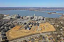
According to the U.S. Census Bureau, National Harbor has a total area of 1.9 square miles (4.8 km2), of which 1.4 square miles (3.7 km2) is land and 0.39 square miles (1.0 km2), or 21.7% (consisting of the Potomac River), is water; 300 acres are in the actual development itself.
Access
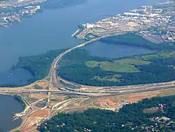

The only routes in or out of National Harbor are several ramps north of the area that link it to nearby major roadways: Interstate 95/495 (the Capital Beltway), Interstate 295 (Anacostia Freeway), and Oxon Hill Road. Commuters traveling via Indian Head Highway may access National Harbor by utilizing the Oxon Hill Road exits.[29] In 2007, the state funded over $500 million (~$683 million in 2022) in road improvements in order to handle the 10,000 cars expected to commute daily to National Harbor.[29]
A water taxi line run by the Potomac Riverboat Company connects the National Harbor to Alexandria, Virginia. The City of Alexandria also runs shuttles from the water taxi terminal to King Street–Old Town station. The service costs the city about $800,000 per year.[30]
Proposals for Metrorail service
Early critics of National Harbor argued that the site is not accessible enough to the Washington Metro, the Washington area's rapid transit system. However, local civic groups dropped a lawsuit against National Harbor's developer in exchange for assurances of greater investment in the surrounding community and better access to mass transit.[31]
The new Woodrow Wilson Bridge, which forms part of the Capital Beltway near National Harbor, was built to allow capacity for a future Washington Metro line.[32] However, there are no current plans to extend rail over the bridge to development. Instead, the state of Maryland pays the Washington Metropolitan Area Transit Authority $312,000 annually to operate the NH1 bus line to National Harbor from the Southern Avenue Metro station. In June 2008, the Gaylord National Resort and Convention Center asked the state to fund additional transit service because employees found it difficult to reach National Harbor.[33] In 2011, Metro began considering the possibility of building a rail extension to National Harbor off the Green Line as part of its long-term plan.[34] The NH2 bus line started running across the Woodrow Wilson Bridge in 2016, connecting with the King Street–Old Town station.[35]
In September 2021, a report on the capacity improvements of Blue/Orange/Silver lines recommended converting the Blue Line into a circle line, extending it to National Harbor and Alexandria.[36] NBC4 Washington further reported on the proposed loop in December 2022. At the time, there was a crowding problem at the Rosslyn station, and the proposed Blue Line loop could be the solution to solve this crowding problem.[37]
Education
National Harbor is part of the Prince George's County Public Schools district.[38]
Schools serving National Harbor include Fort Foote Elementary School,[39] Oxon Hill Middle School,[40] and Oxon Hill High School.[41]
Gallery
 The Awakening, an unusual sculpture in National Harbor
.jpg.webp) Capital Wheel at night
Capital Wheel at night Peeps store
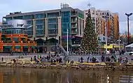 A Christmas Tree in National Harbor in 2011
 National Harbor stores and restaurants
 Aerial view of the Gaylord Resort & Convention Center
Panorama


See also
References
- 1 2 U.S. Geological Survey Geographic Names Information System: National Harbor, Michigan
- ↑ "2020 U.S. Gazetteer Files". United States Census Bureau. Retrieved April 26, 2022.
- ↑ "National Harbor CDP, Maryland". United States Census Bureau. Retrieved April 15, 2022.
- ↑ "NATIONAL HARBOR WILL HONOR 14 HARBOR HEROES ON JULY 13". National Harbor. Retrieved September 24, 2023.
- 1 2 3 Waite, Andrew (March 3, 2011). "Forgotten Oxon Hill plantation celebrates county's black heritage, historians say". Gazette. Post Community Media, LLC. Retrieved April 27, 2016.
- ↑ "National Harbor a threat to the Potomac". Baltimore Sun. 7 January 1998. Retrieved 14 May 2015.
- ↑ "The Wilson Crossing: A Better Vision". The Sierra Club, Maryland Chapter. April 26, 1999. Archived from the original on June 10, 2009. Retrieved 2009-03-15.
- ↑ Zapotosky, Matt (June 23, 2008). "Residents Blame National Harbor for Sewage Spills". Washington Post. Retrieved 2009-03-15.
- ↑ "Gaylord National Resort opens". Virginia Business. June 1, 2008. Retrieved April 26, 2016.
- ↑ Berger, Judson (March 29, 2007). "National Harbor designers envision a bustling attraction". Gazette. Retrieved April 26, 2016.
- ↑ "Grand Vision for National Harbor Takes Form". The Washington Post. Retrieved 14 May 2015.
- ↑ Washington Post, 04apr16, page b1
- ↑ Heath, Thomas (November 25, 2011). "In a blow to Prince George's, Disney backs out of National Harbor". The Washington Post. Retrieved November 25, 2011.
- ↑ Cooper, Rachel (October 7, 2015). "National Children's Museum - Washington, DC". Tripsavvy. About. Retrieved April 26, 2016.
- ↑ "Opening day of Tanger Outlets at National Harbor lures shoppers before dawn". The Washington Post. Retrieved 14 May 2015.
- 1 2 3 Cooper, Rachel (April 20, 2016). "National Harbor: Shop, Dine and Play Along the Potomac". About Travel. About. Retrieved April 26, 2016.
- ↑ Wagner, John (8 May 2013). "MGM confirms plans to bid for Prince George's County casino". Washington Post. Retrieved 8 May 2013.
- ↑ "Local Motors To Open Location at National Harbor - National Harbor". National Harbor. Peterson Companies. 12 January 2015. Retrieved 21 July 2016.
- ↑ Rachel, Kurzius. "Meet Olli, The Driverless Vehicle Cruising Around National Harbor". DCist. Archived from the original on 18 July 2016. Retrieved 21 July 2016.
- ↑ "A Titanic Exhibit Opens at National Harbor Next Month".
- ↑ "Alexandria Restoration Project". UAC Restoration Group. 2011-09-30.
- ↑ Miller, Stephen (2009-06-09). "National Harbor to cyclists, pedestrians: Drop dead". Greater Greater Washington. Retrieved 2014-08-20.
- ↑ Stutz, HOWARD. "At Maryland's National Harbor, MGM Resorts wants to fit in — and stand out". Las Vegas Review-Journal. Retrieved 14 May 2015.
- ↑ "Decennial Census of Population and Housing by Decades". US Census Bureau.
- 1 2 "P2 HISPANIC OR LATINO, AND NOT HISPANIC OR LATINO BY RACE – 2010: DEC Redistricting Data (PL 94-171) – National Harbor CDP, Maryland". United States Census Bureau.
- 1 2 "P2 HISPANIC OR LATINO, AND NOT HISPANIC OR LATINO BY RACE – 2020: DEC Redistricting Data (PL 94-171) – National Harbor CDP, Maryland". United States Census Bureau.
- ↑ "GENERAL PROFILE 1: PERSONS BY RACE, AGE, AND SEX; URBAN AND RURAL: National Harbor CDP, Maryland" (PDF). U.S. Census Bureau, American Factfinder. Retrieved December 23, 2011.
- ↑ Lazo, Luz (2023-06-05). "Eight years after opening, National Harbor anticipates new life after MGM". Washington Post. ISSN 0190-8286. Retrieved 2023-07-03.
- 1 2 Wiggins, Ovetta (2007-06-09). "Direct Access Planned For National Harbor". The Washington Post. Retrieved 2009-02-02.
- ↑ Downey, Kirstin (2008-04-01). "Tourism Hopes Riding On Alexandria Trolley". The Washington Post. Retrieved 2009-02-02.
- ↑ Wiggins, Ovetta (2004-08-12). "National Harbor Suit Dropped". The Washington Post. Retrieved 2009-02-02.
- ↑ "Region Needs New Potomac River Bridge". The Huffington Post. Retrieved 2011-09-24.
- ↑ Wiggins, Ovetta (2008-06-04). "Gaylord Resort Asks for More Transit Service". The Washington Post. Retrieved 2009-02-02.
- ↑ "Metro planners contemplate system's second generation". Retrieved 14 May 2015.
- ↑ Lazo, Luz (2023-04-11). "Eight years and one casino later, a bus line from Alexandria to National Harbor". Washington Post. ISSN 0190-8286. Retrieved 2023-07-03.
- ↑ "Blue/Orange/Silver Capacity & Reliability Study" (PDF). WMATA. September 9, 2021. Archived (PDF) from the original on September 7, 2021. Retrieved September 11, 2021.
- ↑ Tuss, Adam (16 December 2022). "Metro Weighs Building Blue Line Loop to Ease Crowding at Rosslyn, Including Georgetown, National Harbor Stops". NBC4 Washington. Retrieved 2023-01-16.
- ↑ "2010 CENSUS - CENSUS BLOCK MAP: National Harbor CDP, MD." U.S. Census Bureau. Retrieved on September 2, 2018.
- ↑ "NEIGHBORHOOD ELEMENTARY SCHOOLS AND BOUNDARIES SCHOOL YEAR 2018-2019." Prince George's County Public Schools. Retrieved on September 2, 2018.
- ↑ "NEIGHBORHOOD MIDDLE SCHOOLS AND BOUNDARIES SCHOOL YEAR 2018-2019." Prince George's County Public Schools. Retrieved on September 2, 2018.
- ↑ "NEIGHBORHOOD HIGH SCHOOLS AND BOUNDARIES SCHOOL YEAR 2018-2019." Prince George's County Public Schools. Retrieved on September 2, 2018.

